stav is lost logo
  • Find Hikes
    • Most recent
    • Trip Report Index
    • Hikes by Region
    • Search Hikes
  • Map
  • About
  • Love
Hike Bitter Ridge and Little Finland Loop in Gold Butte National Monument, Nevada - Stav is Lost

Hike Bitter Ridge and Little Finland Loop Gold Butte National Monument, NV

Class 3 13.4 miles 3500 gain 7-10 hrs Loop
Effort
Beauty
Personality
Solitude
DirectionsRoute MapDownload GPX

Mar 28, 2018 — Black Butte Road, the dirt road off of Gold Butte Road, the main road into the national monument, was fine for my car. There are sections that may require higher clearance, but it only gets more rough about a mile from where I parked at the base of Bitter Ridge.

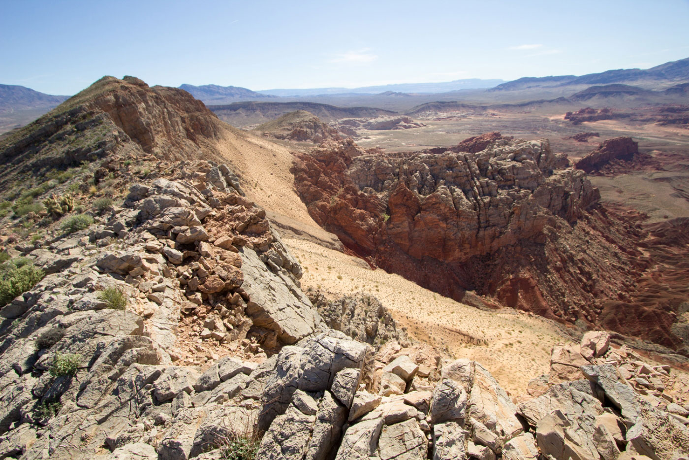
This exploratory route through Gold Butte National Monument includes the high point of Bitter Ridge, and the interesting Little Finland (aka Hobgoblin's Playground). I wasn't sure if my car could make it out to Little Finland, so I contrived a general route to try to make the day more interesting than bumping over rocks in my Subaru for hours. So, I decided to park at the base of Bitter Ridge, along Black Butte Road, and hike along the ridge, which included a couple of Class 3 downclimbs, until I could find a reasonable way down. After summitting the high point and looking southeast into the red rock absurdity, I got too excited and wanted to get off Bitter Ridge as soon as I could to go explore the washes and colorful rocks. The way down I took was probably not the best - it was very steep and sandy and just didn't feel particularly kind to the slope. Once I started down, though, I just kept going. From below, the ridge didn't seem to ease up much farther down, but maybe there's something more reasonable that I couldn't see? Anyway, once off Bitter Ridge, I found a beautiful bright red sandy wash nestled between lumps of red that I followed past a seeping rock and deeper into Gold Butte National Monument. My route is on the map attached, but it's sort of a choose your own adventure sort of deal. Just be careful of all the cryptobiotic soil that is pretty much everywhere and try to follow animal trails, of which there were many. Along the way, I also passed some brightly colored formations that reminded me of the famous The Wave, and even entered a section of slick narrows. Eventually, I made it past the very green Red Rock Springs Wash and to Little Finland, where there are an uncountable number of interesting flaky rock formations. I continued through the rocky area that surrounded Little Finland and found a pretty straightforward Class 3 route up into a region with many small natural arches everywhere before I found a Class 2 gully back down to the opposite side of Little Finland. From here, I continued up the Red Rock Springs Wash and took a side trip up a narrow slot canyon between two white domes before continuing through the white domes and finding another narrow slot that led me to flatter land northeast of the white domes area. A trail brought me back to the parking area.

PEAKS ON HIKE
Elevation (ft) / Prominence (ft)
Peaks on hike
Elevation
Prominence
1
Bitter Ridge
3268 ft
906 rise

Show me some love

Please consider helping me out if you find my site useful. I'm not sponsored, so all site fees are out-of-pocket and my time preparing these trip reports is unpaid. You can also hire me as a web developer. I really appreciate it!

Thank you

Next HikePrev Hike
  • Next Hike
  • More Near Here
  • Prev Hike
photo protector Starting up Bitter Ridge.
Starting up Bitter Ridge.
photo protector Looking back along Bitter Ridge, my car is parked near the wash below.
Looking back along Bitter Ridge, my car is parked near the wash below.
photo protector No caption.
photo protector Continuing along Bitter Ridge.
Continuing along Bitter Ridge.
photo protector Looking back along Bitter Ridge.
Looking back along Bitter Ridge.
photo protector High point of Bitter Ridge ahead.
High point of Bitter Ridge ahead.
photo protector Looking back along Bitter Ridge, red rock formations below.
Looking back along Bitter Ridge, red rock formations below.
photo protector My goal was to get down into the red wash to the left.
My goal was to get down into the red wash to the left.
photo protector Looking back along Bitter Ridge.
Looking back along Bitter Ridge.
photo protector Crazy red rock formations below.
Crazy red rock formations below.
photo protector Continuing down Bitter Ridge.
Continuing down Bitter Ridge.
photo protector Looking back toward one of the Class 3 down climbs.
Looking back toward one of the Class 3 down climbs.
photo protector Almost to another small high point along Bitter Ridge.
Almost to another small high point along Bitter Ridge.
photo protector Looking back along Bitter Ridge.
Looking back along Bitter Ridge.
photo protector Another down climb on Class 3 along Bitter Ridge. I decided to scramble down on the left toward the colorful sandy stuff you see.
Another down climb on Class 3 along Bitter Ridge. I decided to scramble down on the left toward the colorful sandy stuff you see.
photo protector Along the sandy slope down from Bitter Ridge. Class 2, but very steep.
Along the sandy slope down from Bitter Ridge. Class 2, but very steep.
photo protector Continuing northeast, Bitter Ridge just to my left. I wanted to check out the red sandy wash I saw from above.
Continuing northeast, Bitter Ridge just to my left. I wanted to check out the red sandy wash I saw from above.
photo protector No caption.
photo protector Heading east among some red bounds. Little Finland is that red grouping of rocks wayyyy in the distance.
Heading east among some red bounds. Little Finland is that red grouping of rocks wayyyy in the distance.
photo protector No caption.
photo protector Looking back up the red moundy wash toward Bitter Ridge.
Looking back up the red moundy wash toward Bitter Ridge.
photo protector Some fun route finding in washes. If you follow my map, there are two or three huge boulders in washes with nice convenient holes to scramble through. Avoid the cryptobiotic soil!
Some fun route finding in washes. If you follow my map, there are two or three huge boulders in washes with nice convenient holes to scramble through. Avoid the cryptobiotic soil!
photo protector Surprising seeping red rock overhang.
Surprising seeping red rock overhang.
photo protector Closeup of the seep.
Closeup of the seep.
photo protector No caption.
photo protector Gorgeous sweeping formations.
Gorgeous sweeping formations.
photo protector No caption.
photo protector Entering open desert for a while.
Entering open desert for a while.
photo protector Short section of slot in a wash.
Short section of slot in a wash.
photo protector No caption.
photo protector Continuing through open desert.
Continuing through open desert.
photo protector Looking back toward Bitter Ridge.
Looking back toward Bitter Ridge.
photo protector Passing Red Rock Springs.
Passing Red Rock Springs.
photo protector Red Rock Springs itself is apparently a bit up this wash, but the spot I passed was really pretty.
Red Rock Springs itself is apparently a bit up this wash, but the spot I passed was really pretty.
photo protector Looking back toward Bitter Ridge and my fun route finding adventure on the way to Little Finland.
Looking back toward Bitter Ridge and my fun route finding adventure on the way to Little Finland.
photo protector Little Finland ahead.
Little Finland ahead.
photo protector Little Finland!
Little Finland!
photo protector Little Finland, looking back toward Bitter Ridge.
Little Finland, looking back toward Bitter Ridge.
photo protector No caption.
photo protector Eventually after taking too many photos of Little Finland in terrible midday lighting, I continued to route-find into the grouping of rocks where Little Finland was. I climbed a couple hundred feet and got to an area on top of the rock outcropping with lot
Eventually after taking too many photos of Little Finland in terrible midday lighting, I continued to route-find into the grouping of rocks where Little Finland was. I climbed a couple hundred feet and got to an area on top of the rock outcropping with lot
photo protector Lots of little arches above Little Finland.
Lots of little arches above Little Finland.
photo protector My little gully to get down from the Little Finland rock outcropping. Bitter Ridge is visible in the distance.
My little gully to get down from the Little Finland rock outcropping. Bitter Ridge is visible in the distance.
photo protector Continuing up Red Rock Springs.
Continuing up Red Rock Springs.
photo protector No caption.
photo protector The lushness of Red Rock Springs fades away eventually and you have a great sandy wash to follow as it enters the area of White Domes.
The lushness of Red Rock Springs fades away eventually and you have a great sandy wash to follow as it enters the area of White Domes.
photo protector No caption.
photo protector Side trip between those two big white domes leads to a short slot.
Side trip between those two big white domes leads to a short slot.
photo protector Between the two domes on my side trip.
Between the two domes on my side trip.
photo protector No caption.
photo protector Back along the main wash, entering the main white domes area.
Back along the main wash, entering the main white domes area.
photo protector White domes narrow slot ahead.
White domes narrow slot ahead.
photo protector No caption.
photo protector Very pretty section of slot within the white domes. It leads to a way out that skirts the white domes' chaos.
Very pretty section of slot within the white domes. It leads to a way out that skirts the white domes' chaos.
photo protector Natural arch in the canyon.
Natural arch in the canyon.
photo protector No caption.
photo protector Escape from the white domes narrow canyon.
Escape from the white domes narrow canyon.
photo protector A trail appears and takes you along the edge of the white domes back to the car.
A trail appears and takes you along the edge of the white domes back to the car.
photo protector Looking back toward the white domes.
Looking back toward the white domes.
photo protector No caption.
photo protector Bitter Ridge ahead, where I started hours ago.
Bitter Ridge ahead, where I started hours ago.

Show Me Some Love

If you find my site helpful, please help me replace my many broken cameras, fund my website fees (hosting, APIs, security), or just support my countless hours of work. I pay for all expenses myself, and all trip reports I post are unpaid and unsponsored, so any support is really appreciated!

If using PayPal, please select their option for "Sending to a friend" so they don't take out fees, thank you.

PayPalVenmoCash App

About  Contact  Love

© 2023 Stavros Basis.

DISCLAIMER: All activities you find on this site are dangerous. I am not responsible for anything you do in the outdoors. Please practice good ethics, and don't take any risks that put yourself or others in danger.


Thanks for visiting!

My site is free to use, but consider sending me a few bucks to help keep it running. Thanks in advance!

Sure!Nope.