stav is lost logo
  • Find Hikes
    • Most recent
    • Trip Report Index
    • Hikes by Region
    • Search Hikes
  • Map
  • About
  • Love
Hike Black Tank Benchmark and Clifty Benchmark Loop in Kofa National Wildlife Refuge, Arizona - Stav is Lost

Hike Black Tank Benchmark and Clifty Benchmark Loop Kofa National Wildlife Refuge, AZ

Class 4 8.2 miles 3300 gain 5-7 hrs Loop
Effort
Beauty
Personality
Solitude
DirectionsRoute MapDownload GPX

Black Tank Benchmark and Clifty Benchmark Loop GPX Track

I will always provide a free route map, but you can also download a hike/drive GPX to assist you and to help support my site. Before sharing my GPX tracks with others, please remember my site is a free resource and I'm charging nominal fees to offset my substantial costs.

GPX track added to your cart.

Add to Cart ($2.50)
View Cart

Jan 21, 2020 — With so little information available about Clifty Benchmark, Matt and I set out analyzing a topo map to try to find an interesting route to its summit. Coming from the east seemed viable, but the road out there could take forever, or maybe not even be passable. Plus, we wanted more of an adventure in Kofa than just walking up a slope to the peak, and the loop we came up with definitely was quite a bit of a route-finding challenge on difficult terrain. It ended up being really nice overall. On this route, we ended up bagging Black Tank Benchmark, Peak 3050, and Clifty Benchmark.

That being said, reaching Black Tank Benchmark is likely much easier if approaching from the canyon directly to its west rather than the fun, but silly, route we ended up taking. If you want to access the peak more easily and less fun, that would be the way to try instead.

We parked at the end of a dirt road leading to a feature called Black Tank, stopping at the wilderness boundary. We continued along the old dirt road into a narrowing drainage, where we decided to take the left fork since the right fork looked like a sheer cliff. This fork required a bit of Class 2 boulder-hopping and slowly became more narrow, eventually leading to a dryfall. Convinced at first that we were cliffed-out, we almost called it a day and went back, but we noticed a potential scramble route to the left of the fall. It went at Class 4, only one or two committing moves required to get to higher ground. We were pretty excited at this point, convinced we'd make it up to Black Tank Benchmark. Once at the top of our scramble, we noted we were a bit high above the fall and located a Class 2 weakness on the right that allowed us to escape the cliffs and get into the wash that led to the dryfall we had avoided. We followed this wash up a steep slope filled with boulders and up to what appeared to be another impassable section. Looking to the right, a brushy gully would have led us generally south, but we didn't know what was at the top of that gully - it looked rough on a topo. Instead, we located a crack in the wall to the right that led diagonally along a ramp to higher ground. A difficult move got us onto this ramp, but after that we ascended on Class 2 terrain to significantly easier ground. We followed a series of washes and ridges, generally heading east, until Black Tank Benchmark was well in our sight. We continued on its west slopes to a short Class 2 section just below the summit. The views from Black Tank Benchmark toward Clifty Benchmark were incredible, and the summit register only had only a small handful of entries.

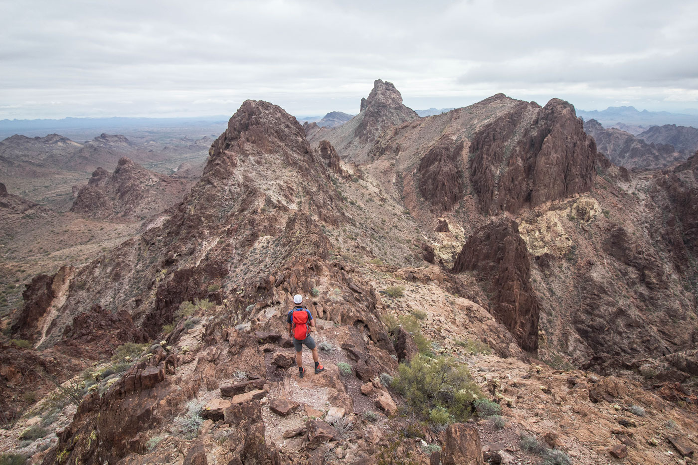
From the summit of Black Tank Benchmark, we noted a ridge leading to the intimidating-looking Clifty Benchmark. We started south, then continued southeast along the rocky ridge, which included an avoidable knife-edge, and we could avoid all cliffy sections by keeping to the right (south), to our relief. The landscape was definitely daunting before starting out along the ridge. We avoided a small, sketchy-looking peak with minimal prominence and continued up Class 2 terrain to Peak 3050, where we got close-up views of Clifty Benchmark and were convinced there was no way we could get the peak from the west.

From Peak 3050, w set out along the south slopes of Clifty Benchmark in search of a weakness, which we found on the south side. A steep gully full of loose rock and brush led north to just right of the summit, where we took in the views to the north a Class 3 section that would take us to Clifty. A few nice moves led straight up the face, and at about halfway up, we worked left on a slightly exposed Class 3 ledge. Alternatively, continuing straight up the face would require a Class 4 move. Once above the crux, we followed the Class 2 ridge to the summit of Clifty Benchmark.

After the summit, we returned to the base of Clifty and then crossed our fingers we could find a route down, rather than backtracking all that way. We made one error which landed us to a severe dryfall, resulting in having to re-ascend. I removed this bit from the attached map.

Our descent route ended up working as Class 2+, and would also work well to ascend Clifty from the west without including the Black Tank Benchmark section of the loop. I short, we followed an obvious drainage from the southern base of Clifty, generally heading southwest, then ascended to a saddle to the west. From the saddle, we worked down a rocky drainage with minimal brushiness safely to the desert floor. We then navigated the desert, trying to be as efficient as possible to get back to the car.

PEAKS ON HIKE
Elevation (ft) / Prominence (ft)
Peaks on hike
Elevation
Prominence
1
Black Tank Benchmark
3103 ft
363 rise
2
Peak 3050
3050 ft
300 rise
3
Clifty Benchmark
3273 ft
1293 rise

Show me some love

Please consider helping me out if you find my site useful. I'm not sponsored, so all site fees are out-of-pocket and my time preparing these trip reports is unpaid. You can also hire me as a web developer. I really appreciate it!

Thank you

Next HikePrev Hike
  • Next Hike
  • More Near Here
  • Prev Hike
photo protector Starting from the wilderness  boundary along  Black Tank Road. Black Tank Benchmark is up there somewhere on the right.
Starting from the wilderness boundary along Black Tank Road. Black Tank Benchmark is up there somewhere on the right.
photo protector Entering the canyon, keeping left at the fork.
Entering the canyon, keeping left at the fork.
photo protector Left fork narrowing.
Left fork narrowing.
photo protector Approaching a dryfall in the left fork (right). Our Class 4 gully to avoid the dryfall visible on the left.
Approaching a dryfall in the left fork (right). Our Class 4 gully to avoid the dryfall visible on the left.
photo protector Avoiding some water on colorful rock, heading to the start of the scramble.
Avoiding some water on colorful rock, heading to the start of the scramble.
photo protector Starting up the Class 4 scramble, looking back down into the left fork.
Starting up the Class 4 scramble, looking back down into the left fork.
photo protector At the top of the Class 4 section, lots of fun moves on solid rock.
At the top of the Class 4 section, lots of fun moves on solid rock.
photo protector Our scramble took us up too high, so we dropped down on a Class 2 weakness into the wash. The dryfall we avoided is out of frame on the bottom right in this photo. Our aim is the head of the drainage, visible center.
Our scramble took us up too high, so we dropped down on a Class 2 weakness into the wash. The dryfall we avoided is out of frame on the bottom right in this photo. Our aim is the head of the drainage, visible center.
photo protector The head of the drainage, where we located a crack, with a ramp ascent, visible center.
The head of the drainage, where we located a crack, with a ramp ascent, visible center.
photo protector Matt pulling a difficult move to access the ramp.
Matt pulling a difficult move to access the ramp.
photo protector Heading up the ramp, Class 2/3.
Heading up the ramp, Class 2/3.
photo protector Class 2 at the top of the ramp, the hard stuff now over.
Class 2 at the top of the ramp, the hard stuff now over.
photo protector At the top of the ramp, we continued into a wash.
At the top of the ramp, we continued into a wash.
photo protector Looking back down the wash we were following. There was one dryfall we avoided on a Class 2 ridge, but otherwise it was pretty straightforward navigating to get to a nice view of Black Tank Benchmark.
Looking back down the wash we were following. There was one dryfall we avoided on a Class 2 ridge, but otherwise it was pretty straightforward navigating to get to a nice view of Black Tank Benchmark.
photo protector Black Tank Benchmark ahead.
Black Tank Benchmark ahead.
photo protector Looking back into the drainage we ascended from, as we head up to Black Tank Bencchmark.
Looking back into the drainage we ascended from, as we head up to Black Tank Bencchmark.
photo protector Black Tank Benchmark summit, view north. Signal Peak visible on the top right.
Black Tank Benchmark summit, view north. Signal Peak visible on the top right.
photo protector Just past the Black Tank Benchmark summit, view southeast toward Clifty Benchmark.
Just past the Black Tank Benchmark summit, view southeast toward Clifty Benchmark.
photo protector Starting along the ridge to get to Clifty Benchmark.
Starting along the ridge to get to Clifty Benchmark.
photo protector Close-up of Clifty Benchmark seen center top, Peak 3050 on the right, and the slopes we used to avoid cliffs along the ridge visible in the center.
Close-up of Clifty Benchmark seen center top, Peak 3050 on the right, and the slopes we used to avoid cliffs along the ridge visible in the center.
photo protector Looking back the way we came, the slopes we used to get from Black Tank visible behind Matt.
Looking back the way we came, the slopes we used to get from Black Tank visible behind Matt.
photo protector As we ascend to Peak 3050, a view looking back toward Black Tank Benchmark (center).
As we ascend to Peak 3050, a view looking back toward Black Tank Benchmark (center).
photo protector Peak 3050 summit, view toward Clifty Benchmark. It was quite imposing from this angle. We decided to head around its south side (center of this photo).
Peak 3050 summit, view toward Clifty Benchmark. It was quite imposing from this angle. We decided to head around its south side (center of this photo).
photo protector Working around the south side of Clifty Benchmark.
Working around the south side of Clifty Benchmark.
photo protector Weakness on Clifty Benchmark's south side.
Weakness on Clifty Benchmark's south side.
photo protector Working up the Class 2 weakness up to a notch.
Working up the Class 2 weakness up to a notch.
photo protector At the notch, Matt doing the Class 3 section up Clifty Benchmark.
At the notch, Matt doing the Class 3 section up Clifty Benchmark.
photo protector Close-up of Matt on the Class 3 section. From where he is in the photo, going straight up is a Class 4 move, but working to the left is a Class 3 lightly exposed ledge leading to safety.
Close-up of Matt on the Class 3 section. From where he is in the photo, going straight up is a Class 4 move, but working to the left is a Class 3 lightly exposed ledge leading to safety.
photo protector Class 2 rest of the ridgeline to Clifty Benchmark summit.
Class 2 rest of the ridgeline to Clifty Benchmark summit.
photo protector Clifty Benchmark ahead!
Clifty Benchmark ahead!
photo protector View northwest toward Black Tank Benchmark (center right), and Peak 3050 (left).
View northwest toward Black Tank Benchmark (center right), and Peak 3050 (left).
photo protector View southeast toward Castle Dome Peak (distant center).
View southeast toward Castle Dome Peak (distant center).
photo protector Coming down from Clifty Benchmark to attempt a reasonable descent without having to retrace our steps.
Coming down from Clifty Benchmark to attempt a reasonable descent without having to retrace our steps.
photo protector From Clifty, we dropped into a wash, and then ascended to a saddle. This is the view from that saddle into the drainage we chose to descend, hoping to not encounter any impassable dryfalls. We didn't!
From Clifty, we dropped into a wash, and then ascended to a saddle. This is the view from that saddle into the drainage we chose to descend, hoping to not encounter any impassable dryfalls. We didn't!
photo protector Class 2+ boulder-hopping and obstacles.
Class 2+ boulder-hopping and obstacles.
photo protector No caption.
photo protector Colorful rocks as we descended.
Colorful rocks as we descended.
photo protector Looking back the way we came.
Looking back the way we came.
photo protector Navigating through the desert in an attempt to find the most efficient route back to the car.
Navigating through the desert in an attempt to find the most efficient route back to the car.

Show Me Some Love

If you find my site helpful, please help me replace my many broken cameras, fund my website fees (hosting, APIs, security), or just support my countless hours of work. I pay for all expenses myself, and all trip reports I post are unpaid and unsponsored, so any support is really appreciated!

If using PayPal, please select their option for "Sending to a friend" so they don't take out fees, thank you.

PayPalVenmoCash App

About  Contact  Love

© 2023 Stavros Basis.

DISCLAIMER: All activities you find on this site are dangerous. I am not responsible for anything you do in the outdoors. Please practice good ethics, and don't take any risks that put yourself or others in danger.


Thanks for visiting!

My site is free to use, but consider sending me a few bucks to help keep it running. Thanks in advance!

Sure!Nope.