stav is lost logo
  • Find Hikes
    • Most recent
    • Trip Report Index
    • Hikes by Region
    • Search Hikes
  • Map
  • About
  • Love
Hike Canyon Point from Cottonwood Canyon in Death Valley National Park, California - Stav is Lost

Hike Canyon Point from Cottonwood Canyon Death Valley National Park, CA

Class 2 5.8 miles 3200 gain 3-5 hrs Loop
Effort
Beauty
Personality
Solitude
DirectionsRoute MapDownload GPX

Canyon Point from Cottonwood Canyon GPX Track

I will always provide a free route map, but you can also download a hike/drive GPX to assist you and to help support my site. Before sharing my GPX tracks with others, please remember my site is a free resource and I'm charging nominal fees to offset my substantial costs.

GPX track added to your cart.

Add to Cart ($2.50)
View Cart

Apr 18, 2021 — Canyon Point is the high point of the mountains separating Marble Canyon and Cottonwood Canyon. These two canyons, when done as a loop, form a popular Death Valley backpacking trip, but it's never had much appeal to me because almost half of it follows the Cottonwood Canyon dirt road. Instead of the loop, simply reaching the high point seemed more my speed. We accessed the trailhead by driving Cottonwood Canyon Road. Head up Cottonwood Canyon Road here (36.63184, -117.29498). The road is great until about a mile before that point, and then it's overall not bad (some short sections where high clearance would be required) except for the last mile, which deteriorated significantly. You may have to hike an extra mile or two each way to reach the end of Cottonwood Canyon Road, depending on driving comfort level.

From the trailhead, we spent a few minutes poking around the pretty cottonwoods before starting up the route to Canyon Point. I recommend taking this extra time to enjoy the area since it's rare to find this much vegetation in Death Valley. The hike starts on the west side of Cottonwood Canyon at the end of the road, heading up a Class 2 set of easy switchbacks to get into a drainage. Once within the drainage, we continued west on lightly sandy and pleasant terrain. Canyon Point came into view after a mile or so, but we wouldn't be ascending directly to it. Instead, we headed south up the slope to reach the ridge. While steep, I think it's likely the best option for reaching Canyon Point from here. Continuing up the approach drainage would result in having to ascend steeper, sandier, or rockier terrain.

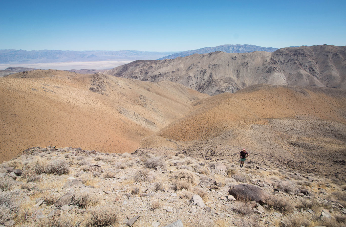
Once on the ridge, we headed west up easy Class 2 terrain on a somewhat steep slope, which brought us to the traverse to the summit. Significantly less steep than the lat half mile, the rest of the route to the summit was scenic and pleasant. A hump along the ridge is worth just going over rather than side-hilling. Large boulders near the summit add some fun Class 2. A Class 2+ summit block gave us some awesome views into Death Valley and toward the sweeping valley around Towne Benchmark.

The most fun part of the day came next. We dropped east off Canyon Point and desended the sandy and fun slope back into the main drainage we used to approach the peak. I highly recommend not ascending this way, but the descent was fast and exciting.

PEAKS ON HIKE
Elevation (ft) / Prominence (ft)
Peaks on hike
Elevation
Prominence
1
Canyon Point
5890 ft
1090 rise

Show me some love

Please consider helping me out if you find my site useful. I'm not sponsored, so all site fees are out-of-pocket and my time preparing these trip reports is unpaid. You can also hire me as a web developer. I really appreciate it!

Thank you

Next HikePrev Hike
  • Next Hike
  • More Near Here
  • Prev Hike
photo protector Depending on how you feel about driving, you may have to hike Cottonwood Canyon Road for a bit before reaching the trailhead.
Depending on how you feel about driving, you may have to hike Cottonwood Canyon Road for a bit before reaching the trailhead.
photo protector Cottonwood Canyon Trailhead, view into the canyon. Just to my right is the start of the route to Canyon Point.
Cottonwood Canyon Trailhead, view into the canyon. Just to my right is the start of the route to Canyon Point.
photo protector Class 2 up the drainage. I'm at the trailhead, looking west. The switchbacks are difficult to see, but start up on the left in this photo.
Class 2 up the drainage. I'm at the trailhead, looking west. The switchbacks are difficult to see, but start up on the left in this photo.
photo protector View back toward the trailhead and Cottonwood Canyon as we head up the Class 2 switchbacks.
View back toward the trailhead and Cottonwood Canyon as we head up the Class 2 switchbacks.
photo protector Within the sandy, pleasant drainage.
Within the sandy, pleasant drainage.
photo protector View back as we make progress up the drainage.
View back as we make progress up the drainage.
photo protector Canyon Point comes into view.
Canyon Point comes into view.
photo protector Another shot back.
Another shot back.
photo protector Canyon Point visible on the right. We would gain its summit by first heading to the darker-colored bump on the left.
Canyon Point visible on the right. We would gain its summit by first heading to the darker-colored bump on the left.
photo protector A minor side-drainage that led to the slope and up to the ridge seen on the left. From the ridge, we'd continue to the darker-colored bump.
A minor side-drainage that led to the slope and up to the ridge seen on the left. From the ridge, we'd continue to the darker-colored bump.
photo protector Looking back into the main drainage as we continue up the slope.
Looking back into the main drainage as we continue up the slope.
photo protector On the ridge heading up to the darker-colored bump.
On the ridge heading up to the darker-colored bump.
photo protector Class 2 as we make our way up.
Class 2 as we make our way up.
photo protector View back down, the drainage we came out of visible on the left.
View back down, the drainage we came out of visible on the left.
photo protector Close-up into the drainage we came out of.
Close-up into the drainage we came out of.
photo protector Once we reached the top of the steep section, we got this view of the route to come. Canyon Point visible top right. We would follow the ridge on the left, over the small inconvenient hump on the left.
Once we reached the top of the steep section, we got this view of the route to come. Canyon Point visible top right. We would follow the ridge on the left, over the small inconvenient hump on the left.
photo protector Approaching the lump.
Approaching the lump.
photo protector Past the lump, continuing along the ridge to the summit.
Past the lump, continuing along the ridge to the summit.
photo protector View back, Towne Benchmark visible top center.
View back, Towne Benchmark visible top center.
photo protector Making our way up along the ridge.
Making our way up along the ridge.
photo protector View back, the drainage we approached within is visible on the left. The black hump we ascended to visible center and runs to the right.
View back, the drainage we approached within is visible on the left. The black hump we ascended to visible center and runs to the right.
photo protector Class 2 summit of Canyon Point.
Class 2 summit of Canyon Point.
photo protector View back from just below the summit of Canyon Point.
View back from just below the summit of Canyon Point.
photo protector On the Class 2+ summit block, view into Death Valley and north toward more of the Panamint Range.
On the Class 2+ summit block, view into Death Valley and north toward more of the Panamint Range.
photo protector View east into the drainage, Tucki Mountain visible top.
View east into the drainage, Tucki Mountain visible top.
photo protector Super fun, fast, steep descend off the east face of Canyon Point.
Super fun, fast, steep descend off the east face of Canyon Point.
photo protector View back up toward Canyon Point as we made our way back into the drainage we approached in.
View back up toward Canyon Point as we made our way back into the drainage we approached in.

Show Me Some Love

If you find my site helpful, please help me replace my many broken cameras, fund my website fees (hosting, APIs, security), or just support my countless hours of work. I pay for all expenses myself, and all trip reports I post are unpaid and unsponsored, so any support is really appreciated!

If using PayPal, please select their option for "Sending to a friend" so they don't take out fees, thank you.

PayPalVenmoCash App

About  Contact  Love

© 2023 Stavros Basis.

DISCLAIMER: All activities you find on this site are dangerous. I am not responsible for anything you do in the outdoors. Please practice good ethics, and don't take any risks that put yourself or others in danger.


Thanks for visiting!

My site is free to use, but consider sending me a few bucks to help keep it running. Thanks in advance!

Sure!Nope.