stav is lost logo
  • Find Hikes
    • Most recent
    • Trip Report Index
    • Hikes by Region
    • Search Hikes
  • Map
  • About
  • Love
Hike Central Peak in Humboldt-Toiyabe National Forest, Nevada - Stav is Lost

Hike Central Peak Humboldt-Toiyabe National Forest, NV

Class 3 6.9 miles 4100 gain 4-6 hrs Loop
Effort
Beauty
Personality
Solitude
DirectionsRoute MapDownload GPX

Central Peak GPX Track

I will always provide a free route map, but you can also download a hike/drive GPX to assist you and to help support my site. Before sharing my GPX tracks with others, please remember my site is a free resource and I'm charging nominal fees to offset my substantial costs.

GPX track added to your cart.

Add to Cart ($2.50)
View Cart

Oct 01, 2022 — Central Peak worked nicely as a warm-up day for our planned outing tomorrow, but it's sort of just another one of those big Great Basin limestone-riddled peaks that blends in with the rest. It's got some fun scrambling and route-finding, but was mostly nice for just the fact that it's a remote hike with typical expansive views, and to catch up with friends. To reach the trailhead, leave the highway and go north here (39.05631, -114.03663), and then head left here (39.30896, -114.00631). The road is overall good and shouldn't cause issues for any car, though decent tires are a good idea.

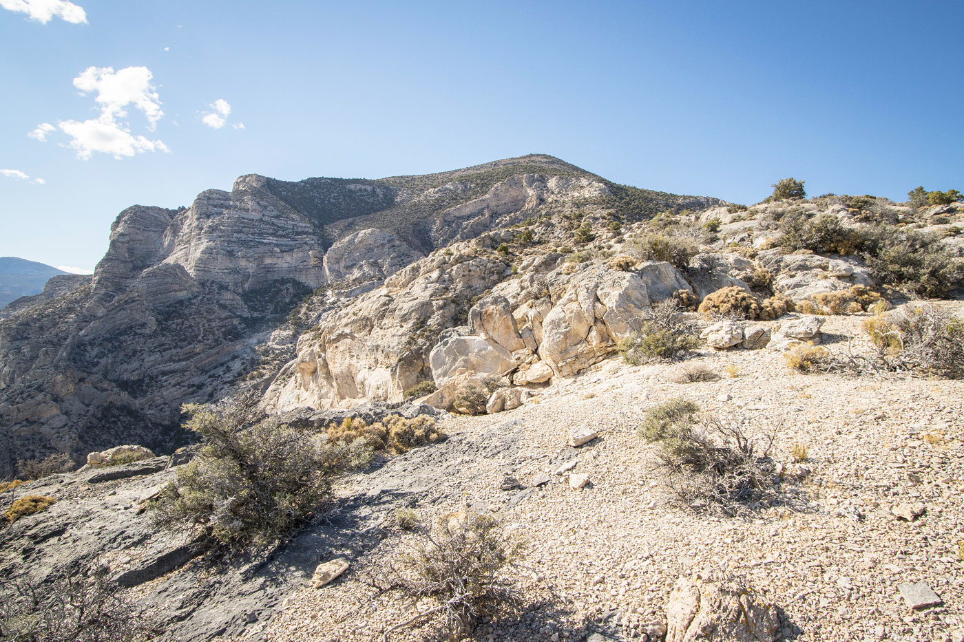
The peak is surrounded by limestone cliff bands in most directions, but a steep drainage/weakness on the east slope seemed like a good option for reaching the summit. We were just sort of fooling around and managed to find two routes, both coming from the east via this drainage. Our ascent route headed up the ridge to the north of the drainage, while the descent was using the southern option. I'd say our ascent route was more fun, but less scenic than the latter. You can also likely make the route easier if you stick closer to the drainage, since both of our route options had rock outcroppings along the ridges, while the drainage seemed to have fewer, though I'm really not sure.

We entered the drainage and hiked until we saw a dryfall ahead. We escaped the wash to the north, picking Class 3 moves on solid limestone, nothing too difficult or exposed. Once above these cliffs, we worked up to the ridgeline, choosing the path with the least brush and climbing up slabby rock when possible. It was mostly just a steep slope with some Class 2 and Class 2+ mixed in here and there. Once along the ridgeline, we realized a limestone outcropping would serve as a fun scrambling obstacle for some time. I guess we were in one of those scrambly kinds of moods rather than efficiency. Though, I chose to take the easiest route when possible, my risk tolerance a bit lower than my companions, keeping left of the outcropping on Class 2/3 terrain, while Sam and Luke tried exploring the jagged crest, often getting cliffed-out and needing to backtrack.

The rocky ridge cleared at around 8400' and we continued west up the sparsely-vegetated steep slope to the summit of Central Peak, where we took in the views of Mount Moriah nearby and of the Deep Creeks to the north. I had earlier judged Luke's choice to get a brownie from a remote gas station as poor, but it was probably the best brownie I ever had, so I praised him for longer than was probably necessary. He regularly makes excellent culinary choices, later that night bringing a full-on charcuterie board to dinner. He claimed it was "just a cutting board", but the fancy sardines and fine cheese selection spoke otherwise.

We decided to head down Central Peak via the southern ridge that straddles the aforementioned drainage. After backtracking along the steeper, rock-free stuff higher up, we continued on still pretty easy terrain. The descent had a bit more sandy and steeper sections, and on the right were a few rock outcrops that we found best to avoid on their left. There was one section at around 7000' where we chose to drop down the slope to avoid a particularly big cliff and the steep/brushy slope at its base, but then we got back to the ridge once the cliff dissipated. Somehow we actually stumbled on the remains of an old mining trail, though it was barely visible. From here it was easy hiking down back to the floor below.

PEAKS ON HIKE
Elevation (ft) / Prominence (ft)
Peaks on hike
Elevation
Prominence
1
Central Peak (Peak 9372)
9372 ft
1252 rise

Show me some love

Please consider helping me out if you find my site useful. I'm not sponsored, so all site fees are out-of-pocket and my time preparing these trip reports is unpaid. You can also hire me as a web developer. I really appreciate it!

Thank you

Next HikePrev Hike
  • Next Hike
  • More Near Here
  • Prev Hike
photo protector Central Peak seen ahead.
Central Peak seen ahead.
photo protector After hiking on mostly flat ground, we reached the eastern side of Central Peak.
After hiking on mostly flat ground, we reached the eastern side of Central Peak.
photo protector Ascending a drainage on the east side.
Ascending a drainage on the east side.
photo protector We headed north out of the drainage when we saw a dryfall ahead.
We headed north out of the drainage when we saw a dryfall ahead.
photo protector Class 3 fun out of the drainage.
Class 3 fun out of the drainage.
photo protector Optional ledge to get over a cliff band.
Optional ledge to get over a cliff band.
photo protector Class 2/3 as we ascend out of the drainage.
Class 2/3 as we ascend out of the drainage.
photo protector Easier terrain higher up as we continue to the ridgeline.
Easier terrain higher up as we continue to the ridgeline.
photo protector View back down into the drainage. Our descent later would come down the ridge seen on the right.
View back down into the drainage. Our descent later would come down the ridge seen on the right.
photo protector Along the ridgeline, Central Peak seen ahead.
Along the ridgeline, Central Peak seen ahead.
photo protector Keeping to the crest meant some scrambling, Class 3 max.
Keeping to the crest meant some scrambling, Class 3 max.
photo protector View back into the drainage as we head along the crest.
View back into the drainage as we head along the crest.
photo protector Cool section along the ridge.
Cool section along the ridge.
photo protector Nice cliffs, more scrambling ahead.
Nice cliffs, more scrambling ahead.
photo protector View back.
View back.
photo protector Class 2/3.
Class 2/3.
photo protector Final class 2 bit until the rocks fade away.
Final class 2 bit until the rocks fade away.
photo protector Pretty steep hiking to the summit in this sort of terrain.
Pretty steep hiking to the summit in this sort of terrain.
photo protector Summit of Central Peak, view west.
Summit of Central Peak, view west.
photo protector Summit of Central Peak, view north toward the Deep Creeks.
Summit of Central Peak, view north toward the Deep Creeks.
photo protector Summit of Central Peak, view southwest toward Mount Moriah.
Summit of Central Peak, view southwest toward Mount Moriah.
photo protector Now headed along the southern ridge, our chosen descent.
Now headed along the southern ridge, our chosen descent.
photo protector Mostly pretty chill, really niec views.
Mostly pretty chill, really niec views.
photo protector No caption.
photo protector View back toward Central Peak. You can also see the northern ridge (our earlier ascent) on the right.
View back toward Central Peak. You can also see the northern ridge (our earlier ascent) on the right.
photo protector Some complex terrain. We kept left of rock outcroppings like the one seen ahead.
Some complex terrain. We kept left of rock outcroppings like the one seen ahead.
photo protector A view into Smith Canyon below.
A view into Smith Canyon below.
photo protector View back toward Central Peak.
View back toward Central Peak.
photo protector Final obstacle ahead. We avoided it by keeping left on the slope.
Final obstacle ahead. We avoided it by keeping left on the slope.
photo protector Avoiding a rock outcrop, then we headed back to the ridge and continued descending to the floor below.
Avoiding a rock outcrop, then we headed back to the ridge and continued descending to the floor below.
photo protector Heading back to the cars.
Heading back to the cars.

Show Me Some Love

If you find my site helpful, please help me replace my many broken cameras, fund my website fees (hosting, APIs, security), or just support my countless hours of work. I pay for all expenses myself, and all trip reports I post are unpaid and unsponsored, so any support is really appreciated!

If using PayPal, please select their option for "Sending to a friend" so they don't take out fees, thank you.

PayPalVenmoCash App

About  Contact  Love

© 2023 Stavros Basis.

DISCLAIMER: All activities you find on this site are dangerous. I am not responsible for anything you do in the outdoors. Please practice good ethics, and don't take any risks that put yourself or others in danger.


Thanks for visiting!

My site is free to use, but consider sending me a few bucks to help keep it running. Thanks in advance!

Sure!Nope.