stav is lost logo
  • Find Hikes
    • Most recent
    • Trip Report Index
    • Hikes by Region
    • Search Hikes
  • Map
  • About
  • Love
Hike Coronado Butte in Grand Canyon National Park, Arizona - Stav is Lost

Hike Coronado Butte Grand Canyon National Park, AZ

Class 3 4.8 miles 2400 gain 3-5 hrs Out and Back
Effort
Beauty
Personality
Solitude
DirectionsRoute MapDownload GPX

Coronado Butte GPX Track

I will always provide a free route map, but you can also download a hike/drive GPX to assist you and to help support my site. Before sharing my GPX tracks with others, please remember my site is a free resource and I'm charging nominal fees to offset my substantial costs.

GPX track added to your cart.

Add to Cart ($2.50)
View Cart

Mar 26, 2022 — Coronado Butte is an iconic formation situated just off the south rim of the Grand Canyon, an excellent peak with some fun route-finding and an incredible backdrop. It's best accessed via the New Hance Trail. The start of the New Hance Trail itself has "no parking" signs, so we used a pullout just down the road instead. Overall it's an easy trail to follow, with cairns marking slightly eroded sections. There are parts that include some Class 2 scrambling, but it's mostly a series of switchbacks leading down from the Grand Canyon's rim. Coronado Butte is visible the whole way down, and the initial goal is to reach the saddle on its southern side.

Once we descended to around 5900' along the New Hance Trail, we were positioned just east of the saddle. We left the trail and ascended a short slope using a social trail to gain the saddle, where Class 2 continued along the spine of the southern ridge of Coronado Butte. After ascending about 600 feet on slabs of sandstone with a couple of short Class 2+/3 moves mixed in, we made it to a small cliff band. This is easily avoidable by using a short, steep gully to the right of the ridge crest (or via a Class 2/3 scramble pretty much anywhere else along the cliff base). Past here is a flatter section where Coronado Butte is positioned directly ahead.

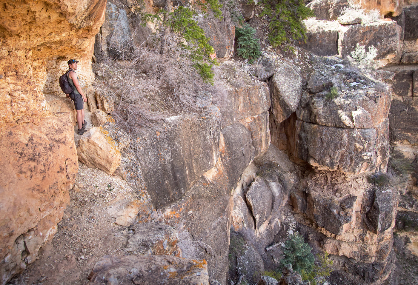
We headed along the wide ridge as it slowly ascended toward the base of the peak's southern cliff. It will be tempting to continue directly to the cliffs, but the ascent route to get above is accessed via the northeast side of the peak. To reach this, there is a social trail that wraps around to the east side of Coronado Butte, staying low and taking its time to ascend rather than leading directly up to the headwall. After wrapping around to the northeast side on easy terrain via this social trail, we were granted excellent views to the north toward the Colorado River and then the initially pretty unnerving-looking northeast face of Coronado Butte. It seems like a series of impassable protruding cliffs separated by gullies. However, hidden by trees, the first gully provides a route. We hugged the cliff face and entered this gully, where some loose and dirty scrambling (Class 2/3) leads to solid Class 3 scrambling.

At the top of this first gully, the route continues on the right using a very cool ledge. The ledge wraps around the first protruding cliff that we'd seen from below. It narrows briefly as it enters the next gully over and becomes a bit exposed, though the scrambling remains Class 2. We started up the second gully, this one going more easily at Class 2/3 with some light brush. Once this gully opens up, we headed to the right, wrapping around yet another of the protruding cliffs we'd seen from below, this time hugging the cliff face on a wider slope/ledge. This ledge continues for a while, but we noted a Class 3 short scramble to get above it, taking this opportunity to gain higher ground. Past here the cliff ahead of us was far too tall to scramble up, but we located a sort of indentation in the cliff where the final bit of Class 3 is found. This spot (the crux, in my opinion) requires a series of fun moves on relatively solid rock. Past this ledge is Class 2 to the summit block of Coronado Butte and the incredible views into the Grand Canyon.

PEAKS ON HIKE
Elevation (ft) / Prominence (ft)
Peaks on hike
Elevation
Prominence
1
Coronado Butte
7162 ft
1122 rise

Show me some love

Please consider helping me out if you find my site useful. I'm not sponsored, so all site fees are out-of-pocket and my time preparing these trip reports is unpaid. You can also hire me as a web developer. I really appreciate it!

Thank you

Next HikePrev Hike
  • Next Hike
  • More Near Here
  • Prev Hike
photo protector After a short walk through the forest along the New Hance Trail, we got to the rim. Coronado Butte seen ahead poking out.
After a short walk through the forest along the New Hance Trail, we got to the rim. Coronado Butte seen ahead poking out.
photo protector Descending along the New Hance Trail. You can see the southern saddle of Coronado Butte above Chris' head.
Descending along the New Hance Trail. You can see the southern saddle of Coronado Butte above Chris' head.
photo protector Along the New Hance Trail, view toward Coronado Butte.
Along the New Hance Trail, view toward Coronado Butte.
photo protector Descending the New Hance Trail.
Descending the New Hance Trail.
photo protector Shortly after this photo was taken we left the trail to head up to the saddle on the left in this photo.
Shortly after this photo was taken we left the trail to head up to the saddle on the left in this photo.
photo protector Ascending the spine, Class 2.
Ascending the spine, Class 2.
photo protector Coronado Butte ahead.
Coronado Butte ahead.
photo protector View back toward the saddle.
View back toward the saddle.
photo protector View back toward the rim as we make our way up the south ridge of Coronado Butte.
View back toward the rim as we make our way up the south ridge of Coronado Butte.
photo protector Class 2.
Class 2.
photo protector Short Class 2/3 sections along the way.
Short Class 2/3 sections along the way.
photo protector Another shot back, the saddle visible behind Josh.
Another shot back, the saddle visible behind Josh.
photo protector A short cliff band ahead, avoidable on the right.
A short cliff band ahead, avoidable on the right.
photo protector Wrapping around the cliff band in search for a way to get above it.
Wrapping around the cliff band in search for a way to get above it.
photo protector Class 2 gully to get over the cliff band.
Class 2 gully to get over the cliff band.
photo protector Coronado Butte comes into view. A flatter section of ridgeline walking leads toward its base.
Coronado Butte comes into view. A flatter section of ridgeline walking leads toward its base.
photo protector Below Coronado Butte's southern cliffs. A social trail wraps around (stay low) to the northeast side.
Below Coronado Butte's southern cliffs. A social trail wraps around (stay low) to the northeast side.
photo protector View back along the ridge. Sinking Ship visible top right.
View back along the ridge. Sinking Ship visible top right.
photo protector Along the social trail as it wraps around, where we also got some great views of the Grand Canyon!
Along the social trail as it wraps around, where we also got some great views of the Grand Canyon!
photo protector A series of cliff protrusions on the northeast face of Coronado Butte. The gully we headed up is located on the left in this photo.
A series of cliff protrusions on the northeast face of Coronado Butte. The gully we headed up is located on the left in this photo.
photo protector View back as we start up the gully.
View back as we start up the gully.
photo protector Class 2/3, loose.
Class 2/3, loose.
photo protector Toward the top of the gully, looking down at the Class 3 found higher up. Less loose and dirty.
Toward the top of the gully, looking down at the Class 3 found higher up. Less loose and dirty.
photo protector At the top of the first gully. You can see Chris starting along the ledge. Josh seen coming up the last bit of the gully.
At the top of the first gully. You can see Chris starting along the ledge. Josh seen coming up the last bit of the gully.
photo protector View back along the ledge toward the first gully.
View back along the ledge toward the first gully.
photo protector The ledge wraps around and becomes more narrow. The ledge leads into the second gully we'd have to ascend, seen center.
The ledge wraps around and becomes more narrow. The ledge leads into the second gully we'd have to ascend, seen center.
photo protector Close-up at the narrowest section. A bit exposed, but only has a short Class 2 section due to the boulder.
Close-up at the narrowest section. A bit exposed, but only has a short Class 2 section due to the boulder.
photo protector View back at the narrow section.
View back at the narrow section.
photo protector Class 2/3 up the second gully.
Class 2/3 up the second gully.
photo protector View back toward the top of the second gully.
View back toward the top of the second gully.
photo protector Another ledge wraps around.
Another ledge wraps around.
photo protector Hugging the cliffs as we wrap around. Above Chris (pink shirt) is a short Class 3 move.
Hugging the cliffs as we wrap around. Above Chris (pink shirt) is a short Class 3 move.
photo protector Short Class 3 move leading to the final Class 3 section.
Short Class 3 move leading to the final Class 3 section.
photo protector A couple of short blocks leads to a few traverse-y moves on the right.
A couple of short blocks leads to a few traverse-y moves on the right.
photo protector Past the last bit of Class 3, easy scrambling leads to the summit block, seen ahead.
Past the last bit of Class 3, easy scrambling leads to the summit block, seen ahead.
photo protector Coronado Butte summit, view south toward the rim.
Coronado Butte summit, view south toward the rim.
photo protector Coronado Butte summit, view north toward the Grand Canyon.
Coronado Butte summit, view north toward the Grand Canyon.
photo protector A shot northeast.
A shot northeast.
photo protector Close-up northeast.
Close-up northeast.

Show Me Some Love

If you find my site helpful, please help me replace my many broken cameras, fund my website fees (hosting, APIs, security), or just support my countless hours of work. I pay for all expenses myself, and all trip reports I post are unpaid and unsponsored, so any support is really appreciated!

If using PayPal, please select their option for "Sending to a friend" so they don't take out fees, thank you.

PayPalVenmoCash App

About  Contact  Love

© 2023 Stavros Basis.

DISCLAIMER: All activities you find on this site are dangerous. I am not responsible for anything you do in the outdoors. Please practice good ethics, and don't take any risks that put yourself or others in danger.


Thanks for visiting!

My site is free to use, but consider sending me a few bucks to help keep it running. Thanks in advance!

Sure!Nope.