stav is lost logo
  • Find Hikes
    • Most recent
    • Trip Report Index
    • Hikes by Region
    • Search Hikes
  • Map
  • About
  • Love
Hike Crystal Peak and Nellie Creek 13ers Loop in Grand Mesa-Uncompahgre-Gunnison National Forest, Colorado - Stav is Lost

Hike Crystal Peak and Nellie Creek 13ers Loop Grand Mesa-Uncompahgre-Gunnison National Forest, CO

Class 2 18.8 miles 6200 gain 8-11 hrs Loop
Effort
Beauty
Personality
Solitude
DirectionsRoute MapDownload GPX

Crystal Peak and Nellie Creek 13ers Loop GPX Track

I will always provide a free route map, but you can also download a hike/drive GPX to assist you and to help support my site. Before sharing my GPX tracks with others, please remember my site is a free resource and I'm charging nominal fees to offset my substantial costs.

GPX track added to your cart.

Add to Cart ($3.50)
View Cart

Sep 12, 2021 — Back to Colorado for my second time this summer. I left Lake City last month a little disappointed at the many peaks I left behind that I wanted to get to this year. I couldn’t help myself and pretty much immediately started planning a trip when I got home. This being day 1, I was excited despite potentially bad weather. And this was in fact quite a stormy and thundery day, not exactly inspiring confidence when hiking at 13,000 feet. I was a bit on edge most of the hike, and photos might show you why. This loop summits three official Colorado 13ers, and I tacked Crystal Peak on at the start to make a really pleasant-looking loop.

Nellie Creek Road would have probably been passable with my crossover for the first couple miles to a hairpin turn a couple of miles up the road, but I didn't know what to expect and decided to walk from the turn-off to Nellie Creek Road. I walked past an ATV that decided to turn around and an abandoned truck that was precariously situated perpendicular to the road. I wouldn’t recommend anything less than a burly of vehicles past this point even though the road does improve afterward. The junction that formed the loop I was planning to do wasn’t far ahead past this hairpin turn anyway. Part of me wished I had driven to this point and walk from there, but I was ultimately content to walk as an extended warmup and save my car’s tires. You can cut off around 5 miles from this hike if you make it to the junction where my loop forms (see map).

After hiking to the road junction at around 10,500 feet I took a right first in order to reach Crystal Peak, doing the loop counter-clockwise. The road past the junction ended shortly after it started, and the trail continued on the opposite side of Nellie Creek along an old road bed. Shortly after starting along the trail I got some initial views of the ridgeline above. The trail (I couldn't find the name of it anywhere) was overall in good shape with a couple of slightly overgrown sections and occasional flooding, but I had no trouble following it through the forest as I made my way up to Crystal Peak. I got an intentional late start to attempt avoiding the predicted poor weather at midday, and sure enough I was pelted with precipitation before emerging from treeline, the first of three close calls. After waiting out some lightning I emerged above tree line at the base of Crystal Peak. The old road switchbacked through the tundra and then started to bend north, so I left the old road/trail and ascended the steep grassy slope to the sloped ridge above.  Now on the north side of Crystal Peak, it was an easy tundra stroll south to the peak. I looked behind me and saw a horrible-looking sotrm coming my way. I convinced myself I could just drop off Crystal Peak and descend to Crystal Lake Trail if the storm got worse and headed my way. Fortunately that didn't happen, but I did feel like I was almost literally playing with lightning with my choices today.

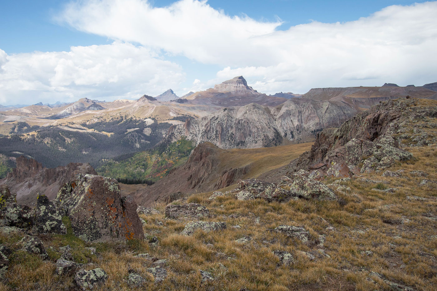
From the gorgeous summit of Crystal Peak, I headed north along the ridgeline on lovely tundra toward my next peak, unnamed 13er Peak 13091. Along the ridge I avoided one grassy hump, and kept left around some interesting white boulders, a totally unexpected rock feature. Reaching Peak 13091 required a Class 2 boulder-hop up to a steeper Class 2/2+ move to gain the rim. Peak 13091's wide summit offered amazing views as I continued west toward Peak 13106, aka "Nellie Point". I dropped down the tundra slope to the saddle separating the two peaks and then made an ascending traverse to the southeast side of Peak 13106, avoiding cliffs on its east slopes. Some steeper tundra and light Class 2 brought me back to the ridgeline, where I was confronted with yet another set of horrible-looking clouds coming my way. I rushed along the interesting Class 2 ridgeline to Peak 13106, a series of blocky boulders creating a maze-like ascent. Without proper foresight, you might have to pull a low Class 3 move here and there, but you can certainly keep the ascent Class 2 by wandering in and out of the blocks.

I descended from the summit of Peak 13106, running through the wide open tundra as lightning got closer. I was definitely freaking out and was sure I'd be bailing on the final peak of the day, Peak 13158. Spoiler: I didn't. I could see it completely shrouded in clouds to the southwest. I made it off the open tundra on the west side of Peak 13106 and reached the trail called Big Blue Creek Trail. I rushed down its switchbacks to lower ground just above treeline right as I was pelted for the second time with rain. I hid under a tree like a dummy rather than descend farther to the official Nellie Creek Trailhead, but the storm seemed to be passing. I got pretty lucky yet again. After hiding out for a few minutes and watching the blue skies come back, I ascended the Nellie Creek Trail to just past a really pretty little waterfall. Here I left the trail and ascended a steep Class 2 talus slope heading generally south. More easy walking through rolling tundra and around a bunch of interesting boulders had me at the base of Peak 13158, my last peak of the day.

I located the saddle on the northwest side of Peak 13158 and chose to make an ascending traverse up the steep tundra/scree slope (Class 2) to the saddle. The views from this saddle to the summit of Peak 13158 were incredible. I could outline my whole route of the day, as well as had clear views of the sweeping tundra around Wetterhorn and Uncompahgre Peaks. I stuck to the ridge crest on Class 2 talus to reach the summit.

To get back to my car I had a couple of options, my initial choice being to backtrack to the Nellie Creek trail and descend the entire road. But then I scoped the terrain to the south and my eyes fixed on what appeared to be a trail. Without any knowledge of a trail's existence here, I decided it would be more fun to attempt a descent using the unknown rather than backtracking. This ended up being an excellent choice. Loose Class 2 brought me down Peak 13158's south slope and back onto glorious tundra. A descended until I stumbled on the trail. Later research revealed that this is called the El Paso Creek Trail. The trail follows a very good old road bed for its entirety, switchbacking quite a bit down the slopes until it reached Nellie Creek Road below. The trail is poorly marked from the road, which is likely why it doesn't get a lot of attention, but it was a really nice trail and provided easy access down from the tundra above. Now it was just a matter of walking back a bunch of miles on Nellie Creek Road to reach my car far below.

PEAKS ON HIKE
Elevation (ft) / Prominence (ft)
Peaks on hike
Elevation
Prominence
1
Crystal Peak
12933 ft
358 rise
2
Peak 13091
13091 ft
571 rise
3
Peak 13106
13106 ft
706 rise
4
Peak 13158
13158 ft
378 rise

Show me some love

Please consider helping me out if you find my site useful. I'm not sponsored, so all site fees are out-of-pocket and my time preparing these trip reports is unpaid. You can also hire me as a web developer. I really appreciate it!

Thank you

Next HikePrev Hike
  • Next Hike
  • More Near Here
  • Prev Hike
photo protector Starting up Nellie Creek Road on foot.
Starting up Nellie Creek Road on foot.
photo protector Higher up on Nellie Creek Road.
Higher up on Nellie Creek Road.
photo protector View back.
View back.
photo protector A stream crossing along the road.
A stream crossing along the road.
photo protector View back as I near the hairpin turn where most cars can't continue.
View back as I near the hairpin turn where most cars can't continue.
photo protector Past the hairpin turn (not pictured), I continued on Nellie Creek Road, made a right at a road junction, and followed this side-road a short way to its end. To start along the trail to Crystal Peak, I crossed Nellie Creek here and located the trail on the opposite side.
Past the hairpin turn (not pictured), I continued on Nellie Creek Road, made a right at a road junction, and followed this side-road a short way to its end. To start along the trail to Crystal Peak, I crossed Nellie Creek here and located the trail on the opposite side.
photo protector The trail is just an old road, easy to follow.
The trail is just an old road, easy to follow.
photo protector Ascending the trail. Gorgeous colors. The cool pinnacle-filled ridge you see on the left is the ridgeline shooting south from Peak 13106.
Ascending the trail. Gorgeous colors. The cool pinnacle-filled ridge you see on the left is the ridgeline shooting south from Peak 13106.
photo protector Continuing along the old road/trail.
Continuing along the old road/trail.
photo protector A flooded section of trail. It was easy to follow, but there were a couple of overgrown sections.
A flooded section of trail. It was easy to follow, but there were a couple of overgrown sections.
photo protector View back as I ascend the old road/trail.
View back as I ascend the old road/trail.
photo protector Almost above treeline.
Almost above treeline.
photo protector View back as I emerge from treeline.
View back as I emerge from treeline.
photo protector Crystal Peak top center. The old road switchbacks through the tundra.
Crystal Peak top center. The old road switchbacks through the tundra.
photo protector View back toward the way I came.
View back toward the way I came.
photo protector The old road/trail continues for a bit through the tundra. I left the trail once it curved north and instead ascended the grassy slope in the center leading to the ridgeline above.
The old road/trail continues for a bit through the tundra. I left the trail once it curved north and instead ascended the grassy slope in the center leading to the ridgeline above.
photo protector Close-up back the way I came after leaving the road/trail (seen on the right). Also visible is the scary storm coming my way, lovely.
Close-up back the way I came after leaving the road/trail (seen on the right). Also visible is the scary storm coming my way, lovely.
photo protector On the ridge, headed toward Crystal Peak.
On the ridge, headed toward Crystal Peak.
photo protector I started running, hoping the storm would miss me. It did, yay.
I started running, hoping the storm would miss me. It did, yay.
photo protector Crystal Peak ahead.
Crystal Peak ahead.
photo protector Final push to Crystal Peak.
Final push to Crystal Peak.
photo protector View back from just below Crystal Peak toward Uncompahgre Peak (left) and Peak 13091 on the right.
View back from just below Crystal Peak toward Uncompahgre Peak (left) and Peak 13091 on the right.
photo protector Crystal Peak, view down into the Modoc Creek drainage at the peak's base. Nellie Creek is on the other side of the ridge in the center of this photo.
Crystal Peak, view down into the Modoc Creek drainage at the peak's base. Nellie Creek is on the other side of the ridge in the center of this photo.
photo protector Crystal Peak summit, view toward Crystal Lake and Lake City in the center.
Crystal Peak summit, view toward Crystal Lake and Lake City in the center.
photo protector A close-up toward Uncompahgre Peak, center. Peak 13158 (my last peak of the day) is the little nubbin along the ridge to the left of Uncompahgre.
A close-up toward Uncompahgre Peak, center. Peak 13158 (my last peak of the day) is the little nubbin along the ridge to the left of Uncompahgre.
photo protector Along the lovely tundra toward Peak 13091 (center).
Along the lovely tundra toward Peak 13091 (center).
photo protector View back toward Crystal Peak.
View back toward Crystal Peak.
photo protector Peak 13091 ahead. Cool rock formations along the way.
Peak 13091 ahead. Cool rock formations along the way.
photo protector View back toward Crystal Peak, just past the cool rock formations.
View back toward Crystal Peak, just past the cool rock formations.
photo protector Class 2 talus, with one Class 2+ move to gain the rim of Peak 13091.
Class 2 talus, with one Class 2+ move to gain the rim of Peak 13091.
photo protector View back from above the Class 2+ move, Crystal Peak center.
View back from above the Class 2+ move, Crystal Peak center.
photo protector Along the rim of Peak 13091. Onward to Peak 13106.
Along the rim of Peak 13091. Onward to Peak 13106.
photo protector View back toward Peak 13091 (left) and Crystal Peak (right).
View back toward Peak 13091 (left) and Crystal Peak (right).
photo protector Peak 13106's eastern reaches visible top right. To reach it, I kept to the right in this photo, ascended above the minor cliff band, and ascended to the summit via the tundra and light Class 2 in the center of this photo.
Peak 13106's eastern reaches visible top right. To reach it, I kept to the right in this photo, ascended above the minor cliff band, and ascended to the summit via the tundra and light Class 2 in the center of this photo.
photo protector View back toward Peak 13091.
View back toward Peak 13091.
photo protector A long walk along the ridge leads to Peak 13106. Uncompahgre Peak visible on the right. Also, another storm coming my way. Again.
A long walk along the ridge leads to Peak 13106. Uncompahgre Peak visible on the right. Also, another storm coming my way. Again.
photo protector View back along the Class 2 blocky ridgeline. You can pull Class 3 moves if you don't wrap between the blocky maze-like formations.
View back along the Class 2 blocky ridgeline. You can pull Class 3 moves if you don't wrap between the blocky maze-like formations.
photo protector Peak 13106 summit, view toward Uncompahgre Peak (right) and Peak 13158 (left).
Peak 13106 summit, view toward Uncompahgre Peak (right) and Peak 13158 (left).
photo protector Class 2 down from Peak 13106. I ran through the tundra on the right to reach the trail.
Class 2 down from Peak 13106. I ran through the tundra on the right to reach the trail.
photo protector View back up toward Peak 13106.
View back up toward Peak 13106.
photo protector Along the tundra to the trail.
Along the tundra to the trail.
photo protector I reached the Big Blue Creek Trail. Peak 13158 visible above.
I reached the Big Blue Creek Trail. Peak 13158 visible above.
photo protector Descending the Big Blue Creek Trail's switchbacks. Uncompahgre Peak visible center.
Descending the Big Blue Creek Trail's switchbacks. Uncompahgre Peak visible center.
photo protector Nellie Creek Road is down there in the center.
Nellie Creek Road is down there in the center.
photo protector Junction with the Nellie Creek Trail. I ascended the trail.
Junction with the Nellie Creek Trail. I ascended the trail.
photo protector View back as I ascend the Nellie Creek Trail. Peak 13106 visible center. I descended via the Big Blue Creek Trail on the left in this photo from the grassy ridge.
View back as I ascend the Nellie Creek Trail. Peak 13106 visible center. I descended via the Big Blue Creek Trail on the left in this photo from the grassy ridge.
photo protector Ascending Nellie Creek Trail, the standard route for Uncompahgre Peak, which is visible ahead.  The pretty little waterfall on the left marked when I'd be leaving the trail to ascend the rocky ridge on the left in this photo.
Ascending Nellie Creek Trail, the standard route for Uncompahgre Peak, which is visible ahead. The pretty little waterfall on the left marked when I'd be leaving the trail to ascend the rocky ridge on the left in this photo.
photo protector Close-up of the little waterfall.
Close-up of the little waterfall.
photo protector I crossed the creek and ascended the talus on the top right.
I crossed the creek and ascended the talus on the top right.
photo protector View back as I ascend the Class 2 talus. Peak 13106 visible top right.
View back as I ascend the Class 2 talus. Peak 13106 visible top right.
photo protector Easy, gorgeous tundra walking with interesting boulders amongst the rolling grassy hills.
Easy, gorgeous tundra walking with interesting boulders amongst the rolling grassy hills.
photo protector Peak 13158 comes into view.
Peak 13158 comes into view.
photo protector Close-up toward Uncompahgre Peak as I ascend to Peak 13158.
Close-up toward Uncompahgre Peak as I ascend to Peak 13158.
photo protector Close-up back toward Peak 13106 as I ascend to Peak 13158.
Close-up back toward Peak 13106 as I ascend to Peak 13158.
photo protector I reached the base of Peak 13158. Now to ascend to the saddle in the center.
I reached the base of Peak 13158. Now to ascend to the saddle in the center.
photo protector Class 2 steep talus/tundra to reach the saddle.
Class 2 steep talus/tundra to reach the saddle.
photo protector At the saddle, ascending the ridge to Peak 13158.
At the saddle, ascending the ridge to Peak 13158.
photo protector Class 2 along the ridge.
Class 2 along the ridge.
photo protector View back. The saddle I came up from is visible center bottom. Uncompahgre Peak and Wetterhorn Peak visible.
View back. The saddle I came up from is visible center bottom. Uncompahgre Peak and Wetterhorn Peak visible.
photo protector Class 2 to Peak 13158.
Class 2 to Peak 13158.
photo protector Another shot back toward the gorgeous landscape. Uncompahgre Peak right of center, Wetterhorn and Matterhorn center, Broken Hill far left.
Another shot back toward the gorgeous landscape. Uncompahgre Peak right of center, Wetterhorn and Matterhorn center, Broken Hill far left.
photo protector Close-up of Broken Hill (left), Wetterhorn and Matterhorn.
Close-up of Broken Hill (left), Wetterhorn and Matterhorn.
photo protector Another close-up (couldn't help myself, omg so beautiful) of Uncompahgre Peak and Wetterhorn Peak.
Another close-up (couldn't help myself, omg so beautiful) of Uncompahgre Peak and Wetterhorn Peak.
photo protector Wide shot of the route I took. Crystal Peak visible right of center in the distance.
Wide shot of the route I took. Crystal Peak visible right of center in the distance.
photo protector Close-up down toward a little tarn and my early traverse in the day from Crystal Peak to Peak 13106.
Close-up down toward a little tarn and my early traverse in the day from Crystal Peak to Peak 13106.
photo protector Close-up into the Nellie Creek drainage. I spotted the El Paso Creek Trail below on the right, and decided to descend to it.
Close-up into the Nellie Creek drainage. I spotted the El Paso Creek Trail below on the right, and decided to descend to it.
photo protector Somewhat loose Class 2 off Peak 13158's south slope.
Somewhat loose Class 2 off Peak 13158's south slope.
photo protector View back up toward Peak 13158.
View back up toward Peak 13158.
photo protector Descending tundra to the El Paso Creek Trail.
Descending tundra to the El Paso Creek Trail.
photo protector View back toward Peak 13158.
View back toward Peak 13158.
photo protector Almost to El Paso Creek Trail.
Almost to El Paso Creek Trail.
photo protector El Paso Creek Trail. I followed this down to Nellie Creek Road.
El Paso Creek Trail. I followed this down to Nellie Creek Road.
photo protector Leaving the Uncompahgre Wilderness.
Leaving the Uncompahgre Wilderness.
photo protector Now below treeline.
Now below treeline.
photo protector Emerging into a little meadow.
Emerging into a little meadow.
photo protector View back through the meadow toward Peak 13158 (top right).
View back through the meadow toward Peak 13158 (top right).
photo protector Nice forested walk.
Nice forested walk.
photo protector No caption.
photo protector Nellie Creek Road ahead.
Nellie Creek Road ahead.
photo protector Close-up of the trail sign, which is placed far enough from the road that I can understand why this trail is rarely visited.
Close-up of the trail sign, which is placed far enough from the road that I can understand why this trail is rarely visited.
photo protector I reached Nellie Creek Road and followed it down back to my car.
I reached Nellie Creek Road and followed it down back to my car.

Show Me Some Love

If you find my site helpful, please help me replace my many broken cameras, fund my website fees (hosting, APIs, security), or just support my countless hours of work. I pay for all expenses myself, and all trip reports I post are unpaid and unsponsored, so any support is really appreciated!

If using PayPal, please select their option for "Sending to a friend" so they don't take out fees, thank you.

PayPalVenmoCash App

About  Contact  Love

© 2023 Stavros Basis.

DISCLAIMER: All activities you find on this site are dangerous. I am not responsible for anything you do in the outdoors. Please practice good ethics, and don't take any risks that put yourself or others in danger.


Thanks for visiting!

My site is free to use, but consider sending me a few bucks to help keep it running. Thanks in advance!

Sure!Nope.