I provide a free route map, but you can also download a hike/drive GPX to assist you and to help support my site. Before sharing my GPX tracks with others, please remember my site is a free resource and I'm charging nominal fees to offset my substantial costs.
GPX track added to your cart.
Jul 19, 2020 — I discovered the wonders of the Tushar Mountains a few years ago, and I have since made many trips to the area. I thought it was time to plan a particularly interesting route to bag the last of the high peaks in the range that I honestly have been very excited to do. This route takes a lesser-used approach to the high peaks, avoiding the somewhat crowded ATV roads used for the standard Delano Peak approaches. It ended up being my favorite hike in the Tushars. This much more interesting route includes Mount Brigham and some other bumps along the ridge from Delano to Brigham. You could knock off 5+ miles off this loop by setting up a shuttle along Wedge Road (the road used for the descent), which was passable by 2WD. The approach road to the trailhead was great as well. I should also mention that if the goal is just bag the peaks then this is not an efficient route, but it does get you into some of the most gorgeous mountain scenery I think Utah has to offer. You could also *cheat* and do this route from top down if you set up the shuttle, reducing the vertical gain by a few thousand feet.
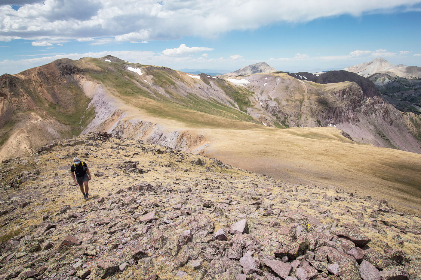
Matt and I started along the Bullion Canyon Trail (074). The hike begins as an ATV road before reaching the official trailhead, a popular hike to Bullion Falls. A quick detour to Bullion Falls is worth the minor effort. The trail then narrows and climbs steeply to get above the cliffs surrounding Bullion Falls. After some pretty meadow walking, we reached a junction with Trail 072. Taking this (left) would be a steep, straight shot up to Delano Peak, but we wanted to continue up Bullion Canyon, our goal being to enjoy the unique Tushar colors and meadows. Ultimately we were really happy we did (see photos). The trail followed Pine Creek toward the Bullion Pasture Trailhead at the head of the creek, but we wouldn't be going that far. I should note that there was a section that the trail completely disappeared (marked on attached map), but it was short-lived and soon we met up with another junction. Here, we turned left onto The Pocket Trail (216). This trail passed through some forest before opening up into incredible views of the colorful cliffs along Delano Peak's eastern face. Initially, I wanted to continue along this trail all the way up to Delano Peak, traversing underneath a feature known as The Pocket. However, we noted this would be very slow since the trail weaved around the base of the cliffs, and would likely be less pretty than just ascending to the ridge early. While I am super happy we did this, I should note that the ridge we ascended was Class 2+ loose scree, the sort of stuff you'd find on nearby iconic Mount Belknap. Continuing along the Pocket Trail would be a trail to the summit of Delano Peak, but we were ready to change it up. I marked the spot we left the trail on my map. This ridge offered the most incredible views of the Tushars I'd seen to date. Behind us were the green and purple bluffs that sloped up to the Copper Belt Peak ridgeline, and as we got higher, Belknap and Baldy became prominent features. Additionally, we could see down Bullion Canyon where we had hiked up, as well as the eastern cliffs of Delano. Stunning stuff.
Once above the Class 2+ scree, we were greeted by the unique and incredible tundra that we would follow for a long time to the summit of Delano Peak. It was bliss. Delano Peak had its usual crowd, and some asshole seems to have recently illegally driven at ATV to the summit, leaving tire marks. We were glad we had spent so much time on a less popular trail, but we took in the views from Delano all the same.
From Delano Peak, we dropped off its eastern ridge and joined up with trail 224 (the trail we would have used to ascend Delano had we continued along The Pocket Traill earlier). Our trail time here was short-lived. We left it to ascend to Delano Peak - East on steep grassy tundra. Mount Holly's cliffs were an interesting sight from this angle. The sweeping ridgeline continued over to Delano - Brigham Ridge Peak, which involved some minor Class 2 on both its ascent and descent. A social trail led us down past some trees and along the undulating ridge to a trailhead labeled Alunite Ridge Trailhead, which doesn't seem often used. Our final ascent to Mount Brigham included some light Class 2 on a steep slope, and the descent from Mount Brigham down to Wedge Road was steep, but uneventful. The road walk down back to the trailhead isn't interesting.
Please consider helping me out if you find my site useful. I'm not sponsored, so all site fees are out-of-pocket and my time preparing these trip reports is unpaid. You can also hire me as a web developer. I really appreciate it!


If you find my site helpful, please help me replace my many broken cameras, fund my website fees (hosting, APIs, security), or just support my countless hours of work. I pay for all expenses myself, and all trip reports I post are unpaid and unsponsored, so any support is really appreciated!
If using PayPal, please select their option for "Sending to a friend" so they don't take out fees, thank you.
My site is free to use, but consider sending me a few bucks to help keep it running. Thanks in advance!