stav is lost logo
  • Find Hikes
    • Most recent
    • Trip Report Index
    • Hikes by Region
    • Search Hikes
  • Map
  • About
  • Love
Hike Dingleberry Peak in Organ Mountains-Desert Peaks National Monument, New Mexico - Stav is Lost

Hike Dingleberry Peak Organ Mountains-Desert Peaks National Monument, NM

Class 3 7.2 miles 3400 gain 4-6 hrs Out and Back
Effort
Beauty
Personality
Solitude
DirectionsRoute MapDownload GPX

Dingleberry Peak GPX Track

I will always provide a free route map, but you can also download a hike/drive GPX to assist you and to help support my site. Before sharing my GPX tracks with others, please remember my site is a free resource and I'm charging nominal fees to offset my substantial costs.

GPX track added to your cart.

Add to Cart ($3.50)
View Cart

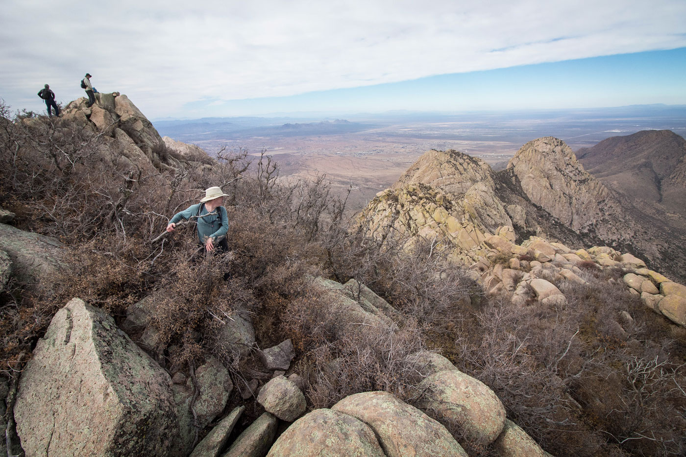
Nov 17, 2019 — A year ago, I attempted Wildcat Peak and failed. I returned this year with a wonderful group and Dingleberry follows basically the same route as Wildcat Peak well into Wildcat Gully, but diverges to the south to follow another gully in order to summit Dingleberry Peak. I joined forces with a great group of Organ Mountains locals: Kevin, Marta, Joe, and Robert. Kevin and I had been talking online for a long time and we were excited to finally able to meet up. Marta has hiked/climbed everything here and has established a million routes. I was happy to meet everyone, and also to hear about all the fun stuff to do in the area. More for my never-ending to do list, I suppose.

Rather than repeating the beta from my Wildcat Peak trip report, in summary, we followed the old bumpy road by foot to Wholt's Welt and into Wildcat Gully. We took Wildcat Gully for a few hundred feet, then headed south over a ridge to enter a gully to the south. We took a sort of haphazard route to avoid a sea of cacti and other desert unpleasantries. It still required a fair amount of not-so-fun bushwhacking, and the ascent gully we chose was steep and loose. We continued toward the ridgeline, a saddle just south of Dingleberry Peak, but did not go all the way. Instead, a minor canyon appeared and became our route choice. Getting up to this small canyon was a chore, but the scrambling was fun once we were within. Some really fun, but thoughtful Class 3 moves took us to the summit of Dingleberry Peak.

PEAKS ON HIKE
Elevation (ft) / Prominence (ft)
Peaks on hike
Elevation
Prominence
1
Dingleberry
8625 ft
175 rise

Show me some love

Please consider helping me out if you find my site useful. I'm not sponsored, so all site fees are out-of-pocket and my time preparing these trip reports is unpaid. You can also hire me as a web developer. I really appreciate it!

Thank you

Next HikePrev Hike
  • Next Hike
  • More Near Here
  • Prev Hike
photo protector Starting up the road toward the Modoc Mine. Dingleberry Peak is just right of center.
Starting up the road toward the Modoc Mine. Dingleberry Peak is just right of center.
photo protector Working up Wholt's Welt. Refer to my Wildcat Peak trip report for more photos/description of the ascent into Wildcat Gully. You can see Wildcat Gully in the center as the diagonal green line. Dingleberry Peak is just right of that line, Wildcat Peak just left.
Working up Wholt's Welt. Refer to my Wildcat Peak trip report for more photos/description of the ascent into Wildcat Gully. You can see Wildcat Gully in the center as the diagonal green line. Dingleberry Peak is just right of that line, Wildcat Peak just left.
photo protector Heading into Wildcat Gully.
Heading into Wildcat Gully.
photo protector No caption.
photo protector Avoiding brush to enter Wildcat Gully.
Avoiding brush to enter Wildcat Gully.
photo protector Working up Wildcat Gully.
Working up Wildcat Gully.
photo protector No caption.
photo protector Looking back down Wildcat Gully.
Looking back down Wildcat Gully.
photo protector A Class 3 move, one of a few, as we worked up.
A Class 3 move, one of a few, as we worked up.
photo protector Well within Wildcat Gully, we crested a ridge separating Wildcat Gully with another gully just to the south. The gully to the south is visible here.
Well within Wildcat Gully, we crested a ridge separating Wildcat Gully with another gully just to the south. The gully to the south is visible here.
photo protector Looking back along the ridge we crested. Wildcat Gully is out of frame on the right.
Looking back along the ridge we crested. Wildcat Gully is out of frame on the right.
photo protector Working up the gully south of Wildcat Gully.
Working up the gully south of Wildcat Gully.
photo protector Looking back down the way we came. It's honestly just a steep, brushy mess.
Looking back down the way we came. It's honestly just a steep, brushy mess.
photo protector No caption.
photo protector Nearing the top of our gully, mostly Class 2, some light Class 3.
Nearing the top of our gully, mostly Class 2, some light Class 3.
photo protector One more look down the steepest section of the gully.
One more look down the steepest section of the gully.
photo protector Dingleberry Peak is up top somewhere. You can see the ridgeline on the right, the saddle just south of Dingleberry Peak. We didn't go to the saddle. Instead, we headed to the canyon seen in the center of this photo.
Dingleberry Peak is up top somewhere. You can see the ridgeline on the right, the saddle just south of Dingleberry Peak. We didn't go to the saddle. Instead, we headed to the canyon seen in the center of this photo.
photo protector It was a fair amount of bushwhacking and work to get into our ascent canyon choice. You can see Marta below.
It was a fair amount of bushwhacking and work to get into our ascent canyon choice. You can see Marta below.
photo protector Ascending the Class 2/3 canyon we chose.
Ascending the Class 2/3 canyon we chose.
photo protector At the top of the canyon, we started up a series of fun, exposed Class 3 moves.
At the top of the canyon, we started up a series of fun, exposed Class 3 moves.
photo protector Class 3 moves just below Dingleberry's summit.
Class 3 moves just below Dingleberry's summit.
photo protector Looking back into the canyon we ascended.
Looking back into the canyon we ascended.
photo protector Some more scrambling just beneath Dingleberry's summit.
Some more scrambling just beneath Dingleberry's summit.
photo protector Dingleberry summit on the left. You can see Rabbit Ears on the right.
Dingleberry summit on the left. You can see Rabbit Ears on the right.
photo protector Looking south toward Organ Needle. Sugarloaf also visible on the left.
Looking south toward Organ Needle. Sugarloaf also visible on the left.

Show Me Some Love

If you find my site helpful, please help me replace my many broken cameras, fund my website fees (hosting, APIs, security), or just support my countless hours of work. I pay for all expenses myself, and all trip reports I post are unpaid and unsponsored, so any support is really appreciated!

If using PayPal, please select their option for "Sending to a friend" so they don't take out fees, thank you.

PayPalVenmoCash App

About  Contact  Love

© 2023 Stavros Basis.

DISCLAIMER: All activities you find on this site are dangerous. I am not responsible for anything you do in the outdoors. Please practice good ethics, and don't take any risks that put yourself or others in danger.


Thanks for visiting!

My site is free to use, but consider sending me a few bucks to help keep it running. Thanks in advance!

Sure!Nope.