stav is lost logo
  • Find Hikes
    • Most recent
    • Trip Report Index
    • Hikes by Region
    • Search Hikes
  • Map
  • About
  • Love
Hike Guadalupe, Shumard, Bartlett, Bush Loop in Guadalupe Mountains National Park, Texas - Stav is Lost

Hike Guadalupe, Shumard, Bartlett, Bush Loop Guadalupe Mountains National Park, TX

Class 2 14.8 miles 5900 gain 7-10 hrs Loop
Effort
Beauty
Personality
Solitude
DirectionsRoute MapDownload GPX

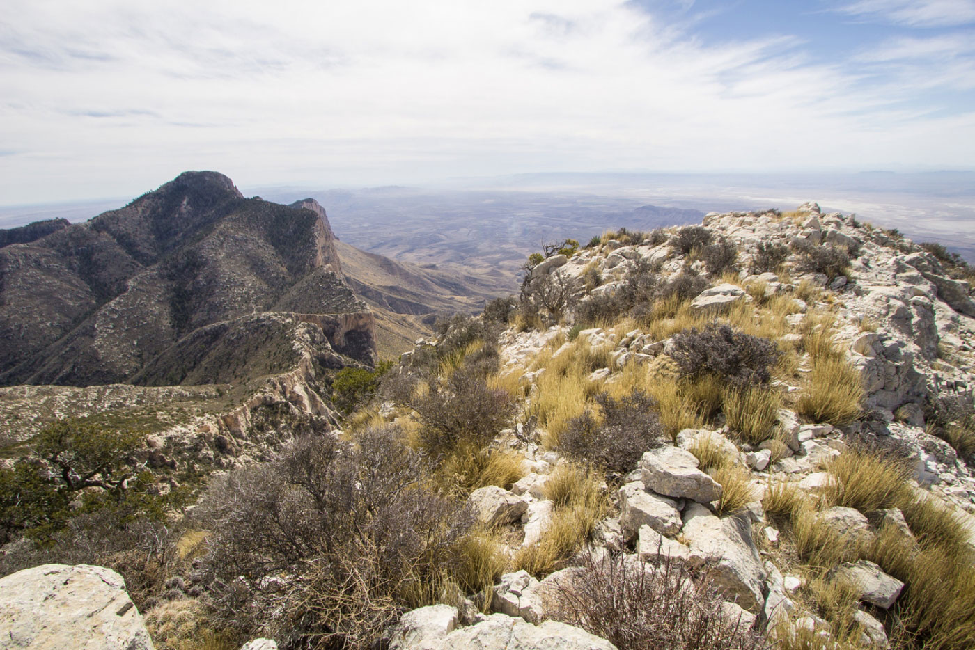
Feb 22, 2018 — The Guadalupe Mountains have always felt like an awesome place to hike, likely because of my love for lush and interesting desert mountain ranges, and this traverse of Guadalupe Peak, Shumard Peak, Bartlett Peak, and Bush Mountain solidifies my love for these mountains. Most of this hike is on established trails, but the long section that is not (the part linking Guadalupe to Bush) is not easy. Expect your legs to be torn up if you don't have pants, and do your best to stay on the absurdly gorgeous cliffy ridge, not only because it has incredible views, but also because that will ensure you avoid much of the unnecessary bushwhacking of which I subjected myself. The traverse might be a little slow-moving because there are only hints of a trail, but it's very enjoyable.

Start on the well-traveled Guadalupe Peak Trail and once you get to the summit, enjoy the views of the ridge you'll be doing all the way out to Bush Mountain. There might be a way down from Guadalupe's north ridge from the summit, but I decided to head down the more obvious east ridge and double back to avoid potentially Class 5 terrain. With decent route planning, tthe entire route won't exceed Class 2. From the ridge under Guadalupe Peak's summit, continue toward Shumard, then Bartlett, and onto Bush, trying to stay along the rim as often as possible. Bartlett Peak is likely the steepest and has some dirty rocky sections, but it's nothing crazy. From Bush Mountain, find the official trail that leads south along the opposite side of the canyon. You'll get views of the traverse from here all the way until you meet up with the Tejas Trail. Take this back down to the Pine Springs Trailhead to complete the loop.

I didn't put a ton of photos for the route up on the Guadalupe Peak Trail, or the route down along the Tejas Trail because I've documented both on other hikes.

PEAKS ON HIKE
Elevation (ft) / Prominence (ft)
Peaks on hike
Elevation
Prominence
1
Guadalupe Peak
8749 ft
3029 rise
2
Shumard Peak
8615 ft
655 rise
3
Bartlett Peak
8508 ft
428 rise
4
Bush Mountain
8631 ft
911 rise

Show me some love

Please consider helping me out if you find my site useful. I'm not sponsored, so all site fees are out-of-pocket and my time preparing these trip reports is unpaid. You can also hire me as a web developer. I really appreciate it!

Thank you

Next HikePrev Hike
  • Next Hike
  • More Near Here
  • Prev Hike
photo protector Starting up toward Guadalupe Peak from the Pine Springs Trailhead.
Starting up toward Guadalupe Peak from the Pine Springs Trailhead.
photo protector Lots of switchbacks.
Lots of switchbacks.
photo protector Hunter Peak on the right.
Hunter Peak on the right.
photo protector No caption.
photo protector False summit of Guadalupe Peak ahead.
False summit of Guadalupe Peak ahead.
photo protector Short meadowy section on the way to Guadalupe Peak.
Short meadowy section on the way to Guadalupe Peak.
photo protector Guadalupe Peak ahead.
Guadalupe Peak ahead.
photo protector Looking back along the Guadalupe Peak Trail, Hunter Peak on the left.
Looking back along the Guadalupe Peak Trail, Hunter Peak on the left.
photo protector El Capitan on the right.
El Capitan on the right.
photo protector Guadalupe Peak summit, Shumard Peak on the left, the next peak along the ridge.
Guadalupe Peak summit, Shumard Peak on the left, the next peak along the ridge.
photo protector From the northern base of Guadalupe along the ridge, looking back toward Guadalupe Peak, El Capitan center right.
From the northern base of Guadalupe along the ridge, looking back toward Guadalupe Peak, El Capitan center right.
photo protector Continuing the bushwhack toward Shumard, ahead.
Continuing the bushwhack toward Shumard, ahead.
photo protector About halfway to Shumard, looking back toward Guadalupe.
About halfway to Shumard, looking back toward Guadalupe.
photo protector Shumard ahead.
Shumard ahead.
photo protector Another view of the ridge from Guadalupe to Shumard.
Another view of the ridge from Guadalupe to Shumard.
photo protector Crazy cliffs along the rim to Shumard.
Crazy cliffs along the rim to Shumard.
photo protector Steep and trailless up to Shumard.
Steep and trailless up to Shumard.
photo protector Shumard Peak summit, looking toward Guadalupe Peak.
Shumard Peak summit, looking toward Guadalupe Peak.
photo protector Close-up of the incredible cliffy rim.
Close-up of the incredible cliffy rim.
photo protector Shumard summit looking toward Bartlett (center) and Bush (far right). There's a couple little sub-peaks along the ridge, but they aren't named.
Shumard summit looking toward Bartlett (center) and Bush (far right). There's a couple little sub-peaks along the ridge, but they aren't named.
photo protector Bushwhacking toward Bartlett.
Bushwhacking toward Bartlett.
photo protector Bartlett ahead on the right
Bartlett ahead on the right
photo protector A bit past halfway on the way to Bartlett, looking back toward Shumard.
A bit past halfway on the way to Bartlett, looking back toward Shumard.
photo protector Bartlett Peak ahead.
Bartlett Peak ahead.
photo protector Easy Class 2 to gain the summit of Bartlett.
Easy Class 2 to gain the summit of Bartlett.
photo protector Almost at the Bartlett summit, looking back toward Shumard. Guadalupe is behind it somewhere.
Almost at the Bartlett summit, looking back toward Shumard. Guadalupe is behind it somewhere.
photo protector Looking north toward Bush Mountain from the Bartlett Peak summit.
Looking north toward Bush Mountain from the Bartlett Peak summit.
photo protector The very serious sheer cliff face along the rim on the way up to Bush Mountain.
The very serious sheer cliff face along the rim on the way up to Bush Mountain.
photo protector Looking southwest at the sheer cliff.
Looking southwest at the sheer cliff.
photo protector Bush Mountain on the right, a sub-peak with no name just ahead. I decided to climb that to avoid the steep and brushy nonsense I'd have to deal with by avoiding the extra elevation gain. It was worth it.
Bush Mountain on the right, a sub-peak with no name just ahead. I decided to climb that to avoid the steep and brushy nonsense I'd have to deal with by avoiding the extra elevation gain. It was worth it.
photo protector Bush Mountain ahead!
Bush Mountain ahead!
photo protector Looking back toward Bartlett. you can see Shumard peeking out just behind it.
Looking back toward Bartlett. you can see Shumard peeking out just behind it.
photo protector Coming down from Bush Mountain on the official Bush Mountain Trail, heading southeast. You can see Bartlett, then Shumard, and finally Guadalupe peeking out way back there.
Coming down from Bush Mountain on the official Bush Mountain Trail, heading southeast. You can see Bartlett, then Shumard, and finally Guadalupe peeking out way back there.
photo protector Looking back along the Bush Mountain Trail. You can see the traverse you just did the whole way.
Looking back along the Bush Mountain Trail. You can see the traverse you just did the whole way.
photo protector Continuing along the Bush Mountain Trail.
Continuing along the Bush Mountain Trail.
photo protector Bush Mountain Trail, Hunter Peak on the left.
Bush Mountain Trail, Hunter Peak on the left.
photo protector Heading down the Tejas Trail, Guadalupe, Shumard, and Bartlett visible.
Heading down the Tejas Trail, Guadalupe, Shumard, and Bartlett visible.
photo protector Tejas Trail.
Tejas Trail.
photo protector Tejas Trail, Guadalupe Peak on the right.
Tejas Trail, Guadalupe Peak on the right.
photo protector Close-up of the Tejas Trail, Devil's Hall below down there somewhere.
Close-up of the Tejas Trail, Devil's Hall below down there somewhere.
photo protector The Tejas Trail leads back down on the opposite side of the Guadalupe Peak Trail.
The Tejas Trail leads back down on the opposite side of the Guadalupe Peak Trail.
photo protector Looking back along the Tejas Trail, just before the trailhead.
Looking back along the Tejas Trail, just before the trailhead.

Show Me Some Love

If you find my site helpful, please help me replace my many broken cameras, fund my website fees (hosting, APIs, security), or just support my countless hours of work. I pay for all expenses myself, and all trip reports I post are unpaid and unsponsored, so any support is really appreciated!

If using PayPal, please select their option for "Sending to a friend" so they don't take out fees, thank you.

PayPalVenmoCash App

About  Contact  Love

© 2023 Stavros Basis.

DISCLAIMER: All activities you find on this site are dangerous. I am not responsible for anything you do in the outdoors. Please practice good ethics, and don't take any risks that put yourself or others in danger.


Thanks for visiting!

My site is free to use, but consider sending me a few bucks to help keep it running. Thanks in advance!

Sure!Nope.