I provide a free route map, but you can also download a hike/drive GPX to assist you and to help support my site. Before sharing my GPX tracks with others, please remember my site is a free resource and I'm charging nominal fees to offset my substantial costs.
GPX track added to your cart.
Oct 06, 2020 — Ibapah Peak is the high point of the Deep Creek Range, and an ultra-prominent peak in Utah. It's very remote, gorgeous, and unlike any of the other peaks I've experienced in the Great Basin desert. I was able to get to the parking spot on my map without difficulty, though I recommend decent tires since Granite Creek Road is a bit rocky in spots. 2WD likely won't be able to make it here due to this creek crossing: 39.7795, -113.86635. Plus, the road does get rocky from there, so expect to add a few more road walking miles if you can't get past the creek. 4WD can make it another mile from my parking spot, which is the farthest vehicles can drive: 39.79653, -113.89553.
Once at the 4WD parking area, whether by vehicle or foot, start past a gated road on the left. This is the trail, and it's in great shape. Although there were a few blowdowns, I experienced no bushwhacking and cairns helped in spots where the trail might be slightly less than clear. The trail passed through small meadows and large stretches of forest as it made its way up Granite Creek Canyon. Ibapah Peak came into view at a certain point and it felt very far away. Red Mountain, a peak I wanted to hike today as well but didn't get to, appeared on the left and tempted me greatly. The trail even parallels a pretty little stream that had some water, despite how dry the year has been.
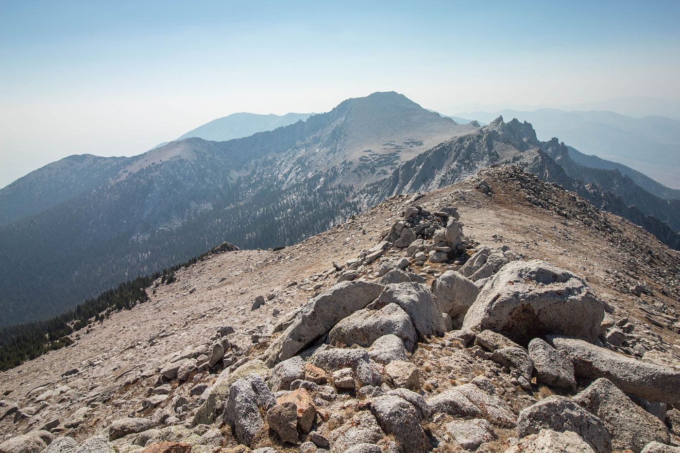
Eventually I made it out of the forest and to the head of Granite Creek Canyon, up to a grassy meadow bowl. I could see Ibapah Peak on the right, and headed through the meadow, losing a small amount of vertical gain. I noted cairns marking the route across the meadow, but they weren't necessary. I started up the forested slope on the north end of the meadow. Although it's hard to determine the best route, I recommend keeping generally to the right of the sloping ridge. Later, the ridge crest will be riddled with talus that gets tedious. About halfway up, I did get on the ridge crest because it was rock-free, but keeping to the right when the ridge appears rocky or steep avoids all the additional scrambling by following a pleasant sloping dirt slope. I know this because I followed the crest the whole way on the ascent, and descended a much easier way (which is what I reflected in the attached map). Toward the top of the ridge, I could see Ibapah Peak and its granite glory. There were a lot of small boulders dotting the now grassy slope, and I stayed along the ridgeline as it climbed up to a forested bump. I don't know if it would be eaier to just go up and over this bump, but a series of social trails seemed to wrap around it on the right, and a more obvious use trail became clear as I wrapped around to the north side of the bump. The trail led to the southwest ridge of Ibapah Peak, where a really well-defined trail led to the summit. There were a few sections with tight switchbacks on the summit ridge, and despite the rocky terrain, the trail removed all Class 2 and kept the hike quite easy.
Once on the summit of Ibapah Peak, I took in the immense views and headed down the north side toward Haystack Peak. My excitement for Haystack Peak despite its additional significant effort was because it's a Utah 12,000 foot peak outside of the Uinta Mountains. Note before going out to Hystack Peak, realize it will add almost an additional 2,000 feet of vertical and the most difficult terrain of the day. It also seems like a lesser-traveled route, likely because it requires coming back the same way and re-ascending Ibapah Peak. Additionally, there's a minor hump about halfway between Ibapah and Haystack that adds more effort to the mix. The Class 2 talus leading down from Ibapah was no big deal, and I kept as high as I could, knowing descending too far on the right would mean extra vertical gain later. Once at the base of Ibapah, the terrain became pleasant through a stunning granite wonderland. The slope was gradual up to the minor hump along the ridge, and I made pretty quick work of it. Not really sure of the best route to Haystack Peak from here, I studied a topo map. I saw some pretty steep-looking contour lines on the opposite side of the ridge hump, so I decided to avoid the hump's high point, where the terrain could get treacherous. I was happy I did, because looking back later revealed a granite cliff on the hump's northeast side that I was thrilled I avoided. Instead, I kept to the right of the hump's summit and somehow stumbled on a Class 2/3 rocky/grassy slope. The slope lost me some vertical gain, but I was able to side-hill to the saddle just below Haystack Peak. I felt efficient and quite thrilled with my small victory. The ridge leading to Haystack Peak is riddled with Class 2/3, but it's overall a fun, though slightly tedious scramble. There are many ways up, but I mostly just stuck to the crest and picked what I thought would bring me the least resistance. At the top of the bouldery ascent, I wrapped around a couple of rock outcroppings and made it to the summit.
The summit views from Haystack Peak were delightful. This was a very remote place indeed. I reversed my route, reascending the Class 2/3 gully to the ridge hump, through the granite wonderland, and back up the slope up to just west of Ibapah Peak. I wanted to also hike up to Red Mountain later on the way back, but I ran out of water and thought maybe it was best I skipped it. Of course while writing this, I regret not going up there even though it's not a particularly interesting-looking peak compared to the granite beauty of Ibapah and Haystack. What a great and long-awaited outing.
Please consider helping me out if you find my site useful. I'm not sponsored, so all site fees are out-of-pocket and my time preparing these trip reports is unpaid. You can also hire me as a web developer. I really appreciate it!


If you find my site helpful, please help me replace my many broken cameras, fund my website fees (hosting, APIs, security), or just support my countless hours of work. I pay for all expenses myself, and all trip reports I post are unpaid and unsponsored, so any support is really appreciated!
If using PayPal, please select their option for "Sending to a friend" so they don't take out fees, thank you.
My site is free to use, but consider sending me a few bucks to help keep it running. Thanks in advance!