I provide a free route map, but you can also download a hike/drive GPX to assist you and to help support my site. Before sharing my GPX tracks with others, please remember my site is a free resource and I'm charging nominal fees to offset my substantial costs.
GPX track added to your cart.
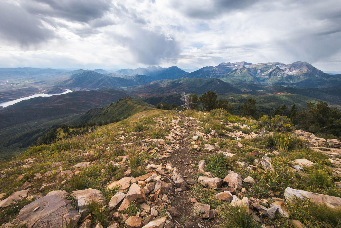
Sep 18, 2023 — Mill Canyon Peak is among the last high-prominence summits I needed to tick off in the Wasatch Mountains. It's been on the backburner since it's located a bit far from the more interesting summits in the Wasatch Front and requires a drive to reach its remote trailhead. Nearby is Peak 9851, another ranked summit I wanted to get to. I was surprised at how fantastic the views were of Mount Timpanogos along the entire hike, as well as north toward the ridgeline housing beauties like Pfeifferhorn and Red Baldy. Take the paved road to here (40.45346, -111.58112) and head north on a dirt road that is overall pretty good and a Crossover SUV can make it to where I did. I parked a few hundred feet before the official trailhead because the road was in much rougher shape and I wasn't sure I could make it. A short hike and I was at the Upper Mill Canyon Trailhead where I picked up the Ridge Trail.
The trail climbs gradually, with excellent views back toward Mount Timpanogos. There's one big switchback that seems to have been replaced by an illegally-cut shortcut, but I stuck to the official trail. Mill Canyon Peak soon becomes visible ahead, though there's still a lot of work to do in order to reach the top of the massive lump. After some nice forested walking, the trail reaches a minor saddle on the south side of the peak, then skirts the slope south of Mill Canyon Peak before reaching its southern ridge. Heading northwest, the Ridge Trail continues just below the crest. A social trail pops in on the right, leading away from the trail and instead sticking to the crest. I'd be returning via the Ridge Trail later.
The ascent to Mill Canyon Peak from here was consistently moderately steep, where a social trail leads the way for the majority. There were a few spots where the trail was more faint, but there's no way to get lost since it's just a straightforward ridge. I passed a junction with the East Ridge Trail at some point, but kept to the crest. I was thoroughly enjoying the views down toward Deer Creek Reservoir, but the views above toward accumulating clouds were less nice. Storms have threatened me on nearly every hike I've been on this summer, so I barely even cared. The Mill Canyon Peak summit has similar views to the rest of the hike so far, so I didn't stick around. I was cold from the wind and drizzle and still wanted to reach Peak 9851 to the west. To get there, I determined it was a good idea to side-hill beneath the north ridge of Mill Canyon Peak in order to avoid a little lump and some potentially brushier terrain. It was pretty steep and newly-wet plants on the slope soaked me and caused me to slip a few times.
I rejoined the main ridgeline and soon stumbled on the Ridge Trail, following it only briefly. A social trail continued toward Peak 9851. I reached a junction of two social trails, one leading along the ridge and more tempting. Though, I recommend keeping right since it ascends just below the crest and follows a nice trail almost all the way to the summit. Just below Peak 9851's true high point, the social trail wraps around the summit and goes elsewhere. I hiked instead through low grasses to the summit, an incredible windswept viewpoint of a seldom-seen perspective of the backside of the Wasatch Range. I backtracked and took the Ridge Trail to complete the loop, happy to finally check out this area, though it was a bittersweet goodbye to summer.
Please consider helping me out if you find my site useful. I'm not sponsored, so all site fees are out-of-pocket and my time preparing these trip reports is unpaid. You can also hire me as a web developer. I really appreciate it!


If you find my site helpful, please help me replace my many broken cameras, fund my website fees (hosting, APIs, security), or just support my countless hours of work. I pay for all expenses myself, and all trip reports I post are unpaid and unsponsored, so any support is really appreciated!
If using PayPal, please select their option for "Sending to a friend" so they don't take out fees, thank you.
My site is free to use, but consider sending me a few bucks to help keep it running. Thanks in advance!