stav is lost logo
  • Find Hikes
    • Most recent
    • Trip Report Index
    • Hikes by Region
    • Search Hikes
  • Map
  • About
  • Love
Hike Mount Neva and Mount Jasper via Arapaho Pass and Diamond Lake Loop in Arapaho-Roosevelt National Forest, Colorado - Stav is Lost

Hike Mount Neva and Mount Jasper via Arapaho Pass and Diamond Lake Loop Arapaho-Roosevelt National Forest, CO

Class 4 10.8 miles 3900 gain 6-8 hrs Loop
Effort
Beauty
Personality
Solitude
DirectionsRoute MapDownload GPX

Sep 15, 2018 — After doing North Arapaho Peak a bit ago, I sort of fell in love with bagging a bunch of peaks in the Indian Peaks Wilderness, and the Mt. Neva to Mt. Jasper traverse seemed like a great time from what I've read. However, I couldn't find a clear, interesting route down from Jasper Peak without backtracking or bushwhacking over marshland, so I was convinced I'd do some exploring and route-find down to the Diamond Lake Trial to make this a less-contrived-feeling loop.

From the Fourth of July Trailhead, head up to Arapaho Pass and continue onward up the north ridge of Mt. Neva. There's some fun Class 3 moves along the ridge, and eventually you get to the base of what looks like a 50-foot sheer cliff, the crux. As you approach, you'll see the climbing looks much more reasonable than it had initially. Much of the time, Class 4 is loose and dangerous and sometimes not that much fun, but this was certainly not that. The route up was solid rock scrambling, and quite intuitive. The last fifteen feet includes some true exposure, but it's definitely only Class 4. I'd say this is a great Class 4 intro for anyone looking to get started on scarier stuff. From the top of the crux, continue on Class 2 to Mt. Neva's summit, and then head along the ridge to Mt. Jasper, with one Class 2+ move along the way.

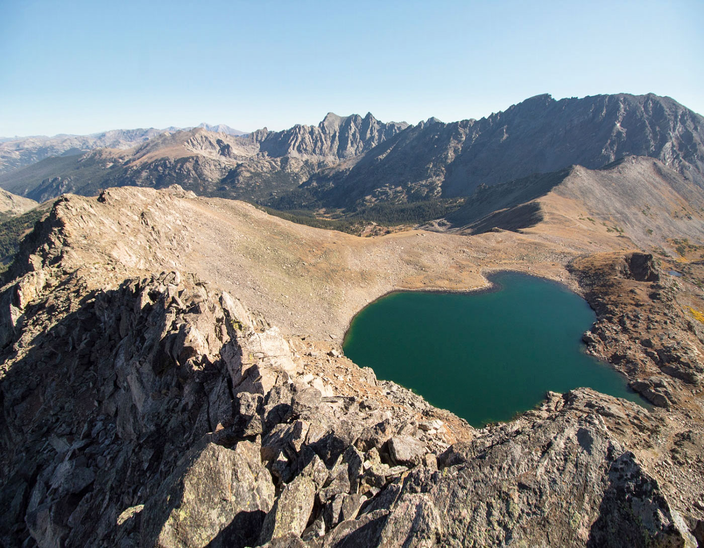
From Mt. Jasper, enjoy the views of the ridge from Mt. Neva to the north, and the absurd number of lakes all around. From here, it was a conflict of the heart for me deciding which way to go start route-finding down - I felt there were three options. The longer, official Devil's Thumb Trail was one option, which I could pick up after heading south from Mt. Jasper, but that would add a ton of miles. The second option would be to take the ridge to the northeast of Mt. Jasper and drop into the cirque east of Mt. Japser, where there's apparently the remains of a plane crash, as well as a small lake, and find a way back to the trail. The third, and the option I chose, was to follow the ridge east of Mt. Jasper and hopefully (!) find a viable scramble down to Upper Dimaond Lake. Turns out it was totally doable (Class 2). From Upper Diamond Lake, hug the south side of the cirque until you find a social trail leading east to Diamond Lake, which is a super popular trail. This leads back to the trailhead.

PEAKS ON HIKE
Elevation (ft) / Prominence (ft)
Peaks on hike
Elevation
Prominence
1
Mount Neva
12814 ft
454 rise
2
Mount Jasper
12923 ft
1003 rise

Show me some love

Please consider helping me out if you find my site useful. I'm not sponsored, so all site fees are out-of-pocket and my time preparing these trip reports is unpaid. You can also hire me as a web developer. I really appreciate it!

Thank you

Next HikePrev Hike
  • Next Hike
  • More Near Here
  • Prev Hike
photo protector Starting up from the Fourth of July Trailhead, head up to Arapaho Pass.
Starting up from the Fourth of July Trailhead, head up to Arapaho Pass.
photo protector No caption.
photo protector Mt. Neva and Mt. Jasper come into view.
Mt. Neva and Mt. Jasper come into view.
photo protector No caption.
photo protector Mt. Neva (center) and Mt. Jasper (left).
Mt. Neva (center) and Mt. Jasper (left).
photo protector Close-up of Mt. Neva and the ridge up to Mt. Jasper.
Close-up of Mt. Neva and the ridge up to Mt. Jasper.
photo protector Looking back the way I came from just below Arapaho Pass.
Looking back the way I came from just below Arapaho Pass.
photo protector Social trail leads up to Mt. Neva's ridgeline (going from right to left to the summit).
Social trail leads up to Mt. Neva's ridgeline (going from right to left to the summit).
photo protector Lake Dorothy, just below Mt. Neva.
Lake Dorothy, just below Mt. Neva.
photo protector The social trail leads right up to the ridge just north of Mt. Neva.
The social trail leads right up to the ridge just north of Mt. Neva.
photo protector Almost at Mt. Neva's ridgeline, looking back toward Arapaho Pass (center) and Lake Dorothy (right).
Almost at Mt. Neva's ridgeline, looking back toward Arapaho Pass (center) and Lake Dorothy (right).
photo protector Rest of the route up the ridge, Mt. Neva in the distance, Lake Dorothy below on the left.
Rest of the route up the ridge, Mt. Neva in the distance, Lake Dorothy below on the left.
photo protector The ridgeline!
The ridgeline!
photo protector Other climbers along the way.
Other climbers along the way.
photo protector Looking back at the first small crux along the ridgeline.
Looking back at the first small crux along the ridgeline.
photo protector No caption.
photo protector The main crux. Once you downclimb a short bit from where I took this photo, there's a couple of easy Class 3 moves that bring you to the base of the diagonal grassy slope in the enter (runs center to top right), with a single Class 4 move. After the grassy slope, a Class 4 section continues to the top. Note that this is not the summit.
The main crux. Once you downclimb a short bit from where I took this photo, there's a couple of easy Class 3 moves that bring you to the base of the diagonal grassy slope in the enter (runs center to top right), with a single Class 4 move. After the grassy slope, a Class 4 section continues to the top. Note that this is not the summit.
photo protector View just below the start of the easy Class 3 moves.
View just below the start of the easy Class 3 moves.
photo protector Looking back down from above the grassy slope.
Looking back down from above the grassy slope.
photo protector The true Class 4 climb. Great holds, but a bad fall for sure.
The true Class 4 climb. Great holds, but a bad fall for sure.
photo protector Looking back along the ridgeline from above the Class 4 scramble.
Looking back along the ridgeline from above the Class 4 scramble.
photo protector Continuing along the ridgeline to Mt. Neva.
Continuing along the ridgeline to Mt. Neva.
photo protector Almost to the Mt. Neva summit, looking down toward Lake Dorothy and South/North Arapaho Peak on the right.
Almost to the Mt. Neva summit, looking down toward Lake Dorothy and South/North Arapaho Peak on the right.
photo protector Continuing along the ridge to the true summit, some easy scrambling along the way.
Continuing along the ridge to the true summit, some easy scrambling along the way.
photo protector Mt. Neva summit looking back the way I came.
Mt. Neva summit looking back the way I came.
photo protector Mt. Neva summit looking south to Mt. Jasper (center).
Mt. Neva summit looking south to Mt. Jasper (center).
photo protector Along the ridge from Neva to Jasper.
Along the ridge from Neva to Jasper.
photo protector No caption.
photo protector Mt. Jasper ahead.
Mt. Jasper ahead.
photo protector Almost on Mt. Jasper, looking back toward Mt. Neva.
Almost on Mt. Jasper, looking back toward Mt. Neva.
photo protector Summit of Mt. Jasper looking north at Mt. Neva.
Summit of Mt. Jasper looking north at Mt. Neva.
photo protector Summit of Mt. Jasper looking south toward Devil's Thumb Pass and Storm Lake. This would have been a route down if I wanted to extend my hike by a bunch of miles.
Summit of Mt. Jasper looking south toward Devil's Thumb Pass and Storm Lake. This would have been a route down if I wanted to extend my hike by a bunch of miles.
photo protector My chosen route - the ridgeline extending east from Mt. Jasper. You can see Upper Diamond Lake on the right.
My chosen route - the ridgeline extending east from Mt. Jasper. You can see Upper Diamond Lake on the right.
photo protector Continuing along the ridgeline, too steep to get down yet.
Continuing along the ridgeline, too steep to get down yet.
photo protector Looking back toward Mt. Jasper (right) along the ridge.
Looking back toward Mt. Jasper (right) along the ridge.
photo protector Finding a reasonable slope down from the ridgeline to get to Upper Diamond Lake.
Finding a reasonable slope down from the ridgeline to get to Upper Diamond Lake.
photo protector Looking back up at the slope I came down.
Looking back up at the slope I came down.
photo protector Upper Diamond Lake, Mt. Jasper behind on the right somewhere.
Upper Diamond Lake, Mt. Jasper behind on the right somewhere.
photo protector Continuing down from Upper Diamond Lake, keeping to the right of the valley until I found a social trail.
Continuing down from Upper Diamond Lake, keeping to the right of the valley until I found a social trail.
photo protector No caption.
photo protector Social trail leading past a bright, small lake.
Social trail leading past a bright, small lake.
photo protector No caption.
photo protector Looking back the way I came, Mt. Jasper peeking out on the right.
Looking back the way I came, Mt. Jasper peeking out on the right.
photo protector No caption.
photo protector Diamond Lake's west bank, where most people stop from the official Diamond Lake Trail.
Diamond Lake's west bank, where most people stop from the official Diamond Lake Trail.
photo protector East bank of Diamond Lake, looking back the way I came.
East bank of Diamond Lake, looking back the way I came.
photo protector No caption.
photo protector Through the forest on the official Diamond Lake Trail.
Through the forest on the official Diamond Lake Trail.
photo protector No caption.
photo protector On the way back up to the Arapaho Pass Trail, looking back toward Mt. Jasper.
On the way back up to the Arapaho Pass Trail, looking back toward Mt. Jasper.

Show Me Some Love

If you find my site helpful, please help me replace my many broken cameras, fund my website fees (hosting, APIs, security), or just support my countless hours of work. I pay for all expenses myself, and all trip reports I post are unpaid and unsponsored, so any support is really appreciated!

If using PayPal, please select their option for "Sending to a friend" so they don't take out fees, thank you.

PayPalVenmoCash App

About  Contact  Love

© 2023 Stavros Basis.

DISCLAIMER: All activities you find on this site are dangerous. I am not responsible for anything you do in the outdoors. Please practice good ethics, and don't take any risks that put yourself or others in danger.


Thanks for visiting!

My site is free to use, but consider sending me a few bucks to help keep it running. Thanks in advance!

Sure!Nope.