I provide a free route map, but you can also download a hike/drive GPX to assist you and to help support my site. Before sharing my GPX tracks with others, please remember my site is a free resource and I'm charging nominal fees to offset my substantial costs.
GPX track added to your cart.
Mar 26, 2019 — I thought the route up to North Peak was a particularly lovely and sustained Class 2-3 scramble in Red Rocks, possibly my favorite in the area. There's really interesting route-finding, and the views and terrain change quite a bit. One thing to note is that there are two summits close together called "North Peak". There's the official North Peak, where a trail labeled as such leads to the summit. This is the taller of the two, situated on the limestone crest, known to peakbaggers as "Crest Peak", but I'll call it "North Peak (limestone)". Then there's the more interesting "North Peak" that marks the end of the fun scrambling for this route, which I'll call "North Peak (sandstone)". Get your peak naming in order, people!
From the Lost Creek Trailhead, locate a shallow gully on the east face of Goodman Peak. You'll want to get to here, but indirectly, since cliff bands block access. Attempt to find a social trail leading to the base of the cliffs just north of the gully's base, where a Class 3 weakness leads to higher ground. I'm not sure that mine was the best trail, but it got me there. Cairns led me past some technical climbers on a ledge, then up the cliffs, and down into the gully. There was water trickling down the gully, creating really pretty waterfalls that always feel unique to Red Rocks. Eventually, the gully leads up to a headwall, where I chose one of a few options for south-ascending slopes leading to Goodman Peak's east ridge. "Willow Springs Overlook" is a point at the easternmost edge of the ridge, offering nice views down toward the Scenic Drive.
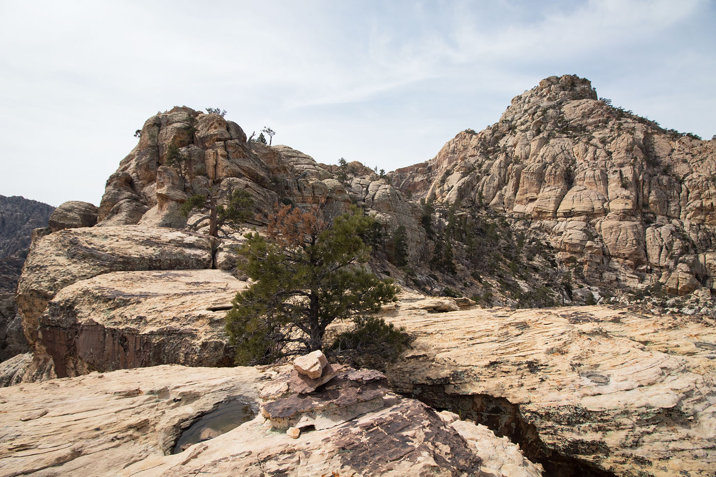
Once along the ridge, I headed west for a bit before cairns led me north on a Class 3 narrow scramble serendipitiously formed by the peakbagging gods to allow access higher up. I circled around Goodman Peak's northern side to gain the summit from the west. I was already particularly happy with the route so far, but it kept on staying interesting as I made my way up to North Peak (sandstone). Immediately after leaving the Goodman Peak saddle, a Class 3 ramp leads up safely to a fixed line around a tree, though the move would likely still be only Class 3 even without the rope. I was then faced with a Class 4-looking scramble on a steep face, just below a false summit of North Peak (sandstone), but decided to avoid it by working around to its left, pulling a couple more Class 3 moves before getting up to the lovely slickrock landscape leading to North Peak (sandstone). There were little pools all over, made for really nice foregrounds for the snow-capped Charleston Peak. The going was easy to North Peak (sandstone) from here and continued to be easy as the sandstone gave way to limestone along the Keystone Thrust and a Class 2+ move was the only obstacle at the summit block of North Peak (limestone). From here, I worked my way back to where the sandstone and limestone met, and continued down a social trail down to Rocky Gap Road, which allowed me to trail run back to my car.
Please consider helping me out if you find my site useful. I'm not sponsored, so all site fees are out-of-pocket and my time preparing these trip reports is unpaid. You can also hire me as a web developer. I really appreciate it!


If you find my site helpful, please help me replace my many broken cameras, fund my website fees (hosting, APIs, security), or just support my countless hours of work. I pay for all expenses myself, and all trip reports I post are unpaid and unsponsored, so any support is really appreciated!
If using PayPal, please select their option for "Sending to a friend" so they don't take out fees, thank you.
My site is free to use, but consider sending me a few bucks to help keep it running. Thanks in advance!