I provide a free route map, but you can also download a hike/drive GPX to assist you and to help support my site. Before sharing my GPX tracks with others, please remember my site is a free resource and I'm charging nominal fees to offset my substantial costs.
GPX track added to your cart.
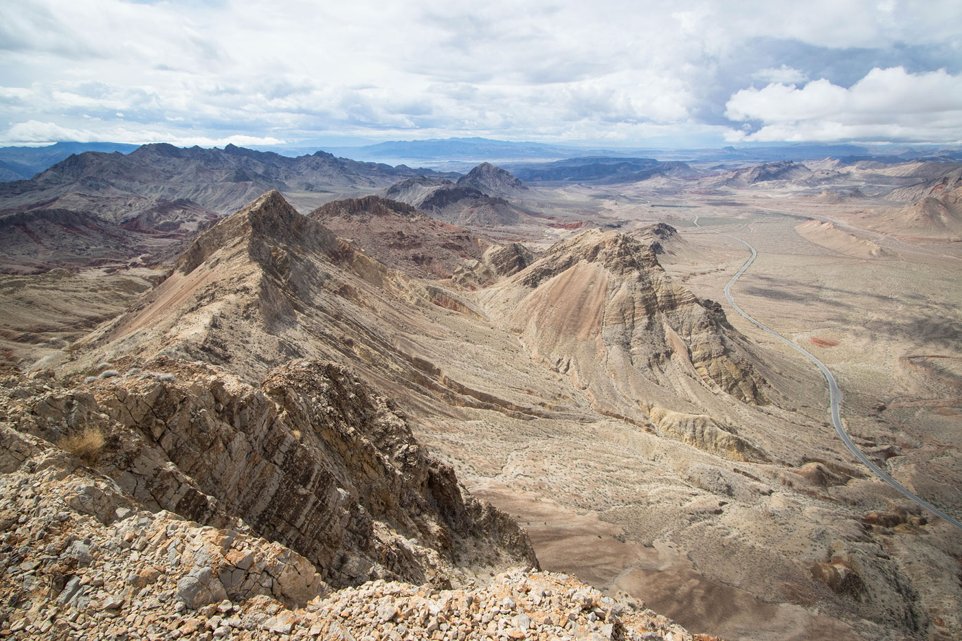
Mar 15, 2023 — One of the more popular peaks in Lake Mead National Recreation Area, Northshore Peak has some of the best views of the colorful surroundings, and is located just off the road. Generally this peak is reached from the Northshore Summit parking lot, the standard route using the descent route I took. However, I was more interested in forming a loop with the sub-peaks of Northshore Peak since I've already done the standard route as an out-and-back and wanted to do a more unique hike. I parked off Northshore Road at a pull-off, deciding I wanted to do this loop counter-clockwise since there were many unknown elements in this direction and it felt prudent to do that stuff first.
After hiking a short time along Northshore Road, I entered a drainage and followed it around to the south side of Northshore Peak - Southwest. This peak has a bad reputation since its northern side is loose, steep, and dangerous. Clearly, hikers haven't found the southern Class 2 slope approach. While still steep, it wasn't anything atypical for the area.
I backtracked from the summit and continued south, hoping to find a way up the cliff bands surrounding my next peak, Northshore Peak - South. This peak is really just an extension of the ridgeline from the primary Northshore Peak, but my intent was to traverse the whole thing and this bump was along the way. Class 2 brought me up a gully and to the southern side of the peak, where I located a Class 3 series of moves on solid rock to gain the crest. You might be able to locate an easier option, but there's more dangerous stuff ahead and this could serve as a nice warm-up.
Once along the crest, I scrambled on fun Class 2/3 slanted slabs to reach the high point, where the views of the colorful badlands to the south were pretty excellent. I started down along the ridgeline and was quickly stopped by what appeared to be a serious cliff. I took my time crawling down on Class 3 terrain, a near-vertical knife of rock. The scramble was on solid limestone, but the drops on either side severe. There were two notable moves, the first a lip that I lowered myself down, the second a wrap-around to the left of an outcropping using a ledge. The going past here was easier to the saddle below.
Class 2/3 led me up the southwest ridge of Northshore Peak, a pleasant scramble on nice rock. From the summit of Northshore Peak I could spot the numerous peaks I've come to know and love in this part of Lake Mead, a fun comparison to the first time I was up here years ago when I hadn't yet hiked as extensively. I continued along the well-cairned standard route. A couple of Class 2 minor cliff bands popped in shortly after starting, and one taller outcropping veered me off the crest for a short time. The slope descended from here, hints of a social trail and an occasional cairn marking the way. I dropped down off the crest using the first slope I could after the cliffs abated, Class 2. Once down to the desert floor, I took a trail for a short time until it faded, and then wandered through the desert to the Northshore Summit Trailhead, where I then hiked down along the road back to my car.
Please consider helping me out if you find my site useful. I'm not sponsored, so all site fees are out-of-pocket and my time preparing these trip reports is unpaid. You can also hire me as a web developer. I really appreciate it!


If you find my site helpful, please help me replace my many broken cameras, fund my website fees (hosting, APIs, security), or just support my countless hours of work. I pay for all expenses myself, and all trip reports I post are unpaid and unsponsored, so any support is really appreciated!
If using PayPal, please select their option for "Sending to a friend" so they don't take out fees, thank you.
My site is free to use, but consider sending me a few bucks to help keep it running. Thanks in advance!