stav is lost logo
  • Find Hikes
    • Most recent
    • Trip Report Index
    • Hikes by Region
    • Search Hikes
  • Map
  • About
  • Love
Hike Pleasant Point in Inyo Mountains BLM, California - Stav is Lost

Hike Pleasant Point Inyo Mountains BLM, CA

Class 2 6.4 miles 2000 gain 2-4 hrs Out and Back
Effort
Beauty
Personality
Solitude
DirectionsRoute MapDownload GPX

Pleasant Point GPX Track

I will always provide a free route map, but you can also download a hike/drive GPX to assist you and to help support my site. Before sharing my GPX tracks with others, please remember my site is a free resource and I'm charging nominal fees to offset my substantial costs.

GPX track added to your cart.

Add to Cart ($2.50)
View Cart

May 01, 2022 — Pleasant Point is best accessed from Cerro Gordo, a silver mine ghost town maintained as a tourist attraction. The peak has a bit of bureaucratic stuff to contend with, but the summit is quite nice and worth the excursion. The drive to reach Cerro Gordo is overall in excellent condition, but the steepness and light rockiness might make sedans hesitate. Upon reaching Cerro Gordo, Tyler and I inquiried about paying a reported access fee to help maintain Cerro Gordo. Since we weren't actually visiting the attraction, the caretaker nicely informed us not to worry about it, and we were off to the trailhead, located at a saddle above the ghost town. We started up the dirt road, which would lead us about halfway to the summit. We later found out that the road we chose to take is off-limits to hikers and vehicles alike (orange line on my attached map), but we didn't know better at the time. Most hikers seem to use this route since it's significantly easier than the "legal" alternative (blue line on my map). I'd recommend inquiring about both the permit and the access road when you visit, since the level of nonchalance may differ depending on the person currently attending the area.

Choosing the orange route means following a road to reach the south ridge of Pleasant Point. The road continues to a minor peak housing some towers (apparently the reason this route isn't okay is to prevent people from getting too close to the towers). A social trail continues along the ridge and wraps around a small hump along the ridge. The legal alternative follows the 4WD Swansea-Cerro Gordo OHV Route (which you could drive to shave off some miles), then leaves the road in order to ascend the steep slope up to the ridgeline, avoiding the off-limits area. I drew this line in for reference, but we did not go that way and my hike stats reflect the orange line only. Either way you go, the route to ascend Pleasant Point remains the same once reaching the ridgeline.

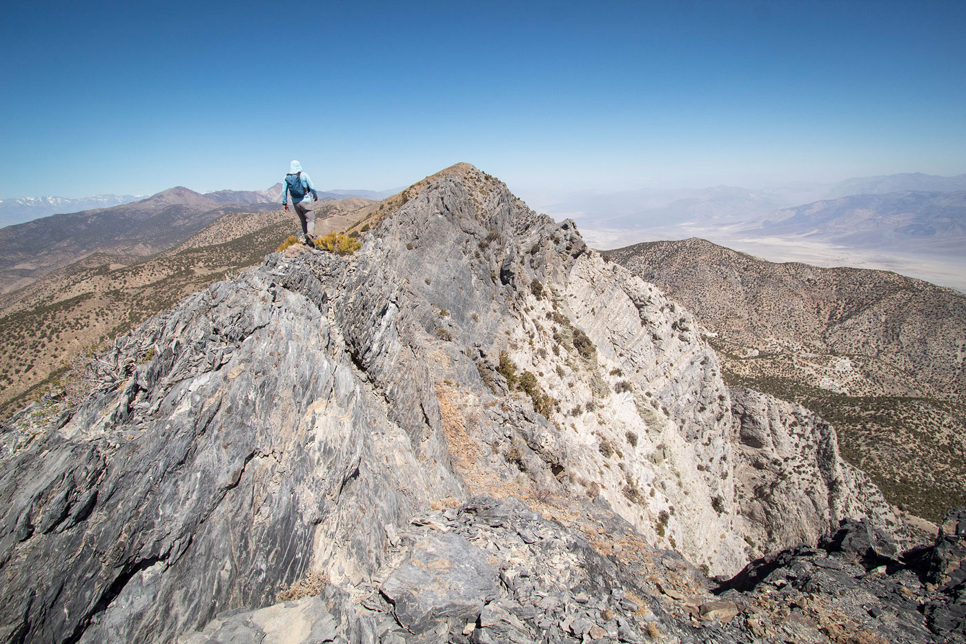
The slope is quite nice as it ascends toward the Pleasant Pinnacles, nothing exceeding light Class 2, nor ever particularly steep. There were a couple of times where sticking to the ridge crest directly resulted in some mild bushwhacking, but it can be avoided on either side using one of a few social trails. We reached the base of the Pleasant Pinnacles, both a very short Class 2 jaunt to reach, and I'd say both are worth checking out since they offer excellent views both toward Pleasant Point and to the east into Saline Valley.

After enjoying the Pleasant Pinnacles views, we headed back down to the social trail, which continues down a small Class 2 gully to avoid a short section of loose rock outcroppings. From here it was more nice walking on a well-defined social trail to the summit of Pleasant Point.

PEAKS ON HIKE
Elevation (ft) / Prominence (ft)
Peaks on hike
Elevation
Prominence
1
Pleasant Pinnacles
9615 ft
95 rise
2
Pleasant Point
9690 ft
1170 rise

Show me some love

Please consider helping me out if you find my site useful. I'm not sponsored, so all site fees are out-of-pocket and my time preparing these trip reports is unpaid. You can also hire me as a web developer. I really appreciate it!

Thank you

Next HikePrev Hike
  • Next Hike
  • More Near Here
  • Prev Hike
photo protector At the trailhead, view north.
At the trailhead, view north.
photo protector Starting along the standard road, technically illegal. You can see the Swansea-Cerro Gordo OHV Route on the far left in this photo, the recommended legal route.
Starting along the standard road, technically illegal. You can see the Swansea-Cerro Gordo OHV Route on the far left in this photo, the recommended legal route.
photo protector Close-up toward Cerro Gordo (top left) and the ghost town.
Close-up toward Cerro Gordo (top left) and the ghost town.
photo protector View into Owens Valley.
View into Owens Valley.
photo protector Along the road. Swansea-Cerro Gordo OHV Route visible below.
Along the road. Swansea-Cerro Gordo OHV Route visible below.
photo protector View back along the road walk section.
View back along the road walk section.
photo protector Pleasant Point comes into view.
Pleasant Point comes into view.
photo protector Along the south ridge to Pleasant Point, a hundred feet or so dip in the ridge leads down from the dirt road. A social trail wraps around the hill ahead.
Along the south ridge to Pleasant Point, a hundred feet or so dip in the ridge leads down from the dirt road. A social trail wraps around the hill ahead.
photo protector Starting the ascent to Pleasant Point.
Starting the ascent to Pleasant Point.
photo protector View back, you can see the social trail that wrapped around the hump.
View back, you can see the social trail that wrapped around the hump.
photo protector Heading up Pleasant Point.
Heading up Pleasant Point.
photo protector View back.
View back.
photo protector Minor Class 2 on the way up.
Minor Class 2 on the way up.
photo protector View back again.
View back again.
photo protector Approaching the base of Pleasant Pinnacles.
Approaching the base of Pleasant Pinnacles.
photo protector Southern Pleasant Pinnacles, view toward Pleasant Point.
Southern Pleasant Pinnacles, view toward Pleasant Point.
photo protector View back toward the southern Pleasant Pinnacle.
View back toward the southern Pleasant Pinnacle.
photo protector View toward Pleasant Point from the northern Pleasant Pinnacle.
View toward Pleasant Point from the northern Pleasant Pinnacle.
photo protector Below Pleasant Pinnacles, a Class 2 short gully descent.
Below Pleasant Pinnacles, a Class 2 short gully descent.
photo protector View back at the social trail leading down the gully.
View back at the social trail leading down the gully.
photo protector Final bit to the summit of Pleasant Point.
Final bit to the summit of Pleasant Point.
photo protector Pleasant Point summit, view south along the ridgeline.
Pleasant Point summit, view south along the ridgeline.
photo protector View north toward Keynot and Inyo.
View north toward Keynot and Inyo.
photo protector View into Saline Valley.
View into Saline Valley.
photo protector View toward Owens Valley.
View toward Owens Valley.

Show Me Some Love

If you find my site helpful, please help me replace my many broken cameras, fund my website fees (hosting, APIs, security), or just support my countless hours of work. I pay for all expenses myself, and all trip reports I post are unpaid and unsponsored, so any support is really appreciated!

If using PayPal, please select their option for "Sending to a friend" so they don't take out fees, thank you.

PayPalVenmoCash App

About  Contact  Love

© 2023 Stavros Basis.

DISCLAIMER: All activities you find on this site are dangerous. I am not responsible for anything you do in the outdoors. Please practice good ethics, and don't take any risks that put yourself or others in danger.


Thanks for visiting!

My site is free to use, but consider sending me a few bucks to help keep it running. Thanks in advance!

Sure!Nope.