I provide a free route map, but you can also download a hike/drive GPX to assist you and to help support my site. Before sharing my GPX tracks with others, please remember my site is a free resource and I'm charging nominal fees to offset my substantial costs.
GPX track added to your cart.
Feb 27, 2021 — The Stepladder Mountains are a small volcanic range in the Mojave Desert with a long enough drive and walk to access them to deter most hikers. Once out here, the high point is generally the only peak people end up going for, but the other little peaks in the area are interesting. Tyler, Matt, and I weren't thrilled about the long drive if it meant only getting the high point, so we planned a few add-ons. Passenger cars can make it here (34.67878, -114.79147), and then the road proceeds as mid-clearance-friendly with some dips, but not particularly rocky.
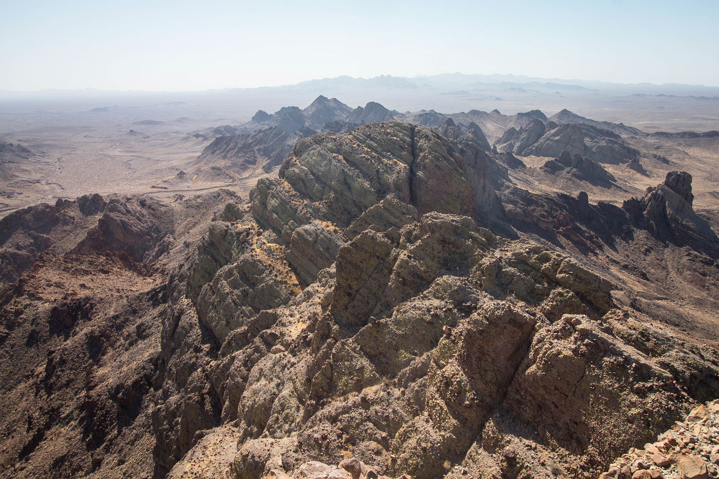
We set out generally southwest through the open desert for a few miles, wrapping around the foothills of the northern Stepladder Mountains and entering a major wash. We followed this wash to the base of Stepladder Mountain, where the rocky/brushy east slopes introduced a few options for ascending the peak. We chose to head up a gully surrounded by volcanic rock outcrops, and encountered some easy Class 3 to get above a series of cliff bands. There are likely easier options to get up to the base of Stepladder Mountain, but the area has lots of volcanic obstacles and I couldn't say what seemed better. Once at the base of the peak, we easily found a delightful conglomerate slab that led up Class 2/3 interesting scrambling up a "seam" - it just looked like a slab of rock was layered on top of the one we were scrambling on. The slab led to a series of interesting switchbacks, barely Class 2 and boasting a nice social trail. The switchbacks brought us to a notch in the conglomerate formation, where left leads to the high point. We checked out the views to the south in an attempt to figure out what peaks were on our itinerary, but it was kind of just a jumble of fun-looking rock.
We backtracked through the switchbacks, and rather than descend back through the cliff band, we headed south in an attempt to find an alternative route down to save time on our way to the next peaks. Although somewhat loose, we made it into the major wash below without incident. The wash led us south, past Stepstool Peak (which we'd end the day on), but slowly started to deviate from the direction we wanted to head, forcing us to leave the wash and head through the desert. Another major drainage on the north side of Conical Benchmark served as a nice access portal to the west side of the Stepladder Mountains, where we planned to go for a peak that we'd later call "Misstep Peak" (more on that in a minute). You might notice we didn't do any peaks in the centeral region of the Stepladder Mountains. None of the central peaks had enough prominence to be "peaks". An unnamed and unranked peak to the north drew our attention, but it looked sheer and likely impossible, so we saved our energy for bigger rocks.
Finding ourselves at the base of Misstep Peak, we briefly debated on the best option. I resisted my friends' excitement to scramble up an unlikely-looking dark chute on the peak's east face, hoping we could wrap around to the west side and find a more reasonable option, but I lost the debate. Fortunately, my friends were right to push for the chute since we later learned there's no way in hell another ascent option exists, the sheer walls of this peak fortifying the summit in pretty much every direction but our chute. The chute started as Class 2, slowly progressing to Class 2+. It involved some fun stemming, but there are some loose boulders and we took turns as not to knock each other out. We reached a point about a hundred feet from the summit where a Class 3+ spine of rock added some optional exposure, but two brushy drainages exist to either side of it (Class 2). However, once above this spine, a single Class 4 move almost stopped me from reaching the summit. A rock rib with a head-sized boulder sticking out at chest-level forced the move to feel far more scary than it was, the feature forcing me to make an arch with my back and slowly shuffle to the left with some severe exposure. The move isn't hard, but the rock feels hollow and slightly crumbly, but nothing popped out for any of us. An alternative exists to the right of the rock rib: a 10-foot Class 5 headwall with ample big pebbles poking out. I used this as a descent option on the way down, too freaked out to do the wrap-around Class 4 move, preferring to risk a pebble popping out and my friends spotting a small fall on this headwall. Class 2 led to the summit, where we found no indication of a previous ascent. Due to the step-around move and the theme of "Stepladders" of the range, we named the peak "Misstep Peak". I inched around the summit area in search for a descent option, hoping our ascent was just us goofing off and finding a hard route unnecessarily, but I couldn't find anything less scary than our choice.
Once back down from Misstep Peak, we headed southeast toward a saddle, working our way on surprisingly pleasant terrain with some minor side-hilling. Conical Benchmark came into view, a quick Class 2 endeavor to its pretty summit. A Class 2 descent led us back into the open desert and back to the major wash we had left earlier, Stepstool Peak the last on our list. Bob Burd's route worked great for this, involving some light Class 2 to the cliffy southern base of Stepstool Peak. We wrapped up and around on rocky Class 2 terrain to the east side of the peak, still following the base of the cliff band. At the end of the cliff band was a cliff, but a Class 3+ short chimney led to the summit block.
Once back down from the chimney, we headed down a Class 2 drainage back to the open desert, following our earlier route for a few miles back to the car.
Please consider helping me out if you find my site useful. I'm not sponsored, so all site fees are out-of-pocket and my time preparing these trip reports is unpaid. You can also hire me as a web developer. I really appreciate it!


If you find my site helpful, please help me replace my many broken cameras, fund my website fees (hosting, APIs, security), or just support my countless hours of work. I pay for all expenses myself, and all trip reports I post are unpaid and unsponsored, so any support is really appreciated!
If using PayPal, please select their option for "Sending to a friend" so they don't take out fees, thank you.
My site is free to use, but consider sending me a few bucks to help keep it running. Thanks in advance!