I provide a free route map, but you can also download a hike/drive GPX to assist you and to help support my site. Before sharing my GPX tracks with others, please remember my site is a free resource and I'm charging nominal fees to offset my substantial costs.
GPX track added to your cart.
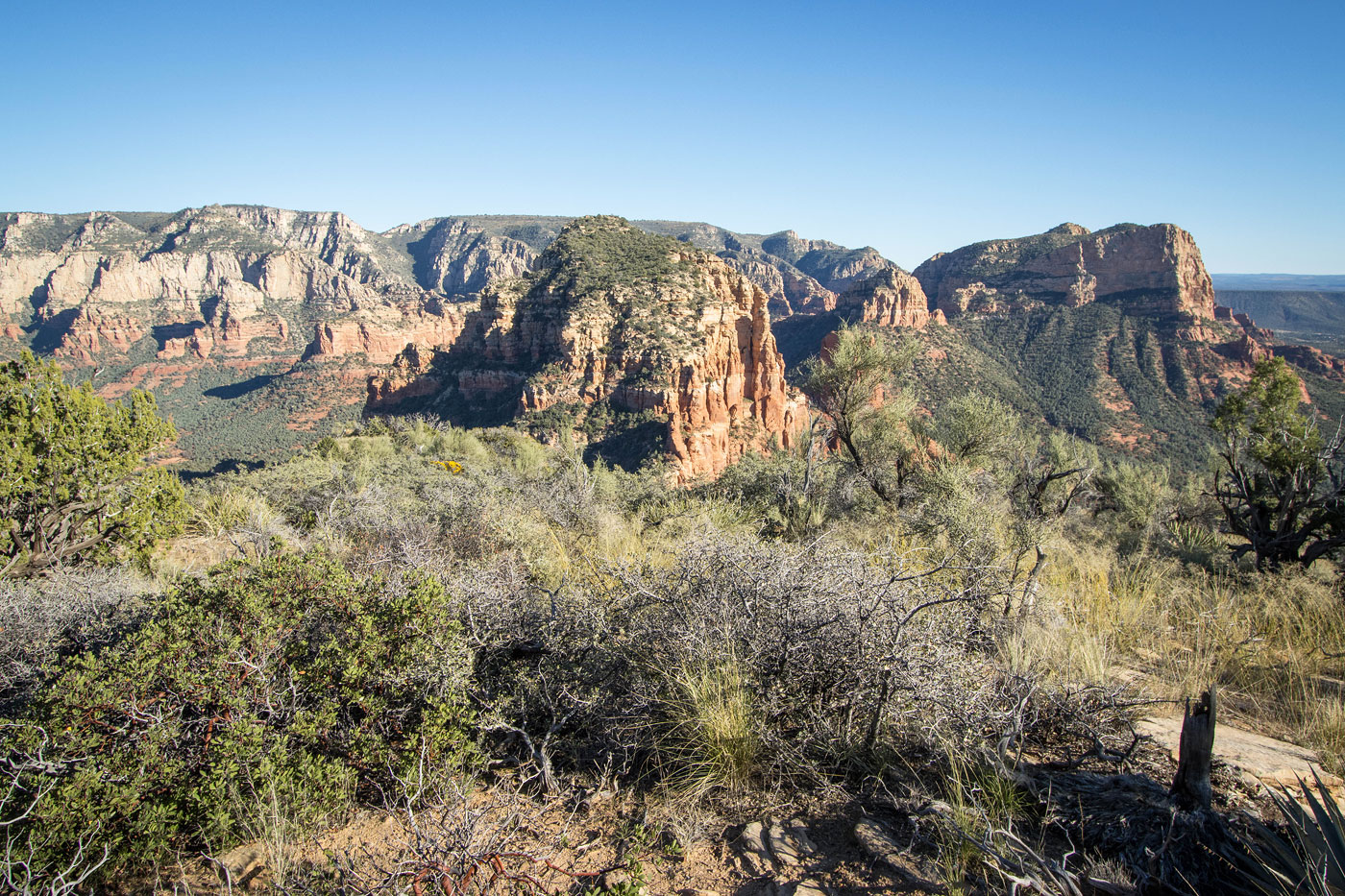
Oct 29, 2022 — The Twin Buttes are a pair of peaks located just south of Sedona, and despite being really close to town few actually hike to the summits. Fortunately, enough people do, allowing for the development of a social trail over time and preventing an annoying bushwhack. The summits both require a Class 3 scramble and some route-finding. I found them both to be great peaks, and the hike is made even better with the addition of Battlement Mesa. I started from the popular Broken Arrow Trailhead, taking the Broken Arrow Trail until it reached the Twin Buttes Trail. Despite the trail's name it doesn't lead anywhere near the summits, but it definitely helps in reaching their base. Used by mountain bikers, the trail is windy and undulating, not-so-directly making its way to the saddle on the north side of Twin Buttes. Along the way I got a nice view of the route to come leading to the peaks, plus some nice overlooks of the surrounding sandstone wonderland.
Once at the saddle, I was happy to locate a social trail that I wasn't sure would actually be there. Previous reports seemed to ascend the peak via any number of gullies or slopes, clearly somewhow not using this trail. It led pretty directly to the saddle separating West Twin Butte from East Twin Butte, picking its way around occasional rock outcrops and helpfully avoiding all the brush. Not locating and using this trail would be a mistake. From the saddle, I decided to tackle the smaller peak, West Twin Butte, hoping to scope out a route up the taller East peak from the higher vantage point. I started toward it, quickly encountering a very fun, pretty exposed, Class 3 set of moves along the ridgeline. Nothing felt unsafe and the holds were all great, but a fall would definitely be not excellent. There was some light brush leading to the summit, but it's a tame hike past the set of ridge crest moves.
Back at the saddle, I headed toward East Twin Butte. I noted a prominent gully from the other summit and hoped I could use it since the faces surrounding the peak looked otherwise sheer. A social trail led below the crest on a steep slope and up to the base of East Twin Butte's substantial cliffs. A nice-looking Class 3+ chimney required some light stemming to ascend. At the top of this chimney, it seems that most parties prefer to continue up the proceeding gully. I played around on this option a bit, and after realizing I was quickly sneaking into Class 4 territory, backed off and looked for another option. Continuing up this gully would definitely work as a route, but the easier option I found begins at the top of the Class 3+ chimney. From here, I made a hairpin turn and traversed along a short ledge away from the gully. When the ledge started to peter out, I scrambled above it using a Class 2/2+ dirty and somewhat brushy portion for about 20 feet and then emerged on a much more tame slope. The slope cotninued steeply with only a few additional Class 2 moves all the way to the summit. Along the way I had to pay attention not to accidentally end up in a brushy scrub oak mess, but for the most part the bushwhacking was minimal.
I backtracked to the saddle where I'd earlier left the Twin Buttes Trail and then headed north toward Battlement Mesa. After some hiking along a social trail I reached the base of the summit block, just a length of snaking rock that results in cliffs on all sides except on the north. I wrapped around the east side (though the west works as well) to get there, and scrambled Class 3 to reach the interesting summit, a narrow catwalk of easy scrambling with drops on either side leading to the high point.
I continued north from Battlement Mesa in search of the descent gully that most seem to use to get off the mesatop. A social trail led some of the way to this weaknes, and Class 2 brought me down through a hollowed-out tunnel kindly carved by previous hikers that prevented a gnarly bushwhack. I was back to the Twin Buttes Trail shortly after that, which I used to return to the Broken Arrow Trailhead.
Please consider helping me out if you find my site useful. I'm not sponsored, so all site fees are out-of-pocket and my time preparing these trip reports is unpaid. You can also hire me as a web developer. I really appreciate it!


If you find my site helpful, please help me replace my many broken cameras, fund my website fees (hosting, APIs, security), or just support my countless hours of work. I pay for all expenses myself, and all trip reports I post are unpaid and unsponsored, so any support is really appreciated!
If using PayPal, please select their option for "Sending to a friend" so they don't take out fees, thank you.
My site is free to use, but consider sending me a few bucks to help keep it running. Thanks in advance!