I provide a free route map, but you can also download a hike/drive GPX to assist you and to help support my site. Before sharing my GPX tracks with others, please remember my site is a free resource and I'm charging nominal fees to offset my substantial costs.
GPX track added to your cart.
Feb 20, 2020 — Nope, not a typo. This loop's proximity to other peaks with dessert-themed names, and the fact that desert is regularly misspelled as dessert warranted the hike name. Located within the craggy peak section of the southeastern Whipple Mountains, this loop ended up being very interesting. After visiting the little peaklets around Whipple Wash about a year ago, I've wanted to return to check out some of the unnamed peaks in the area. These scrambly peaks are rugged and require some fun route-finding. Despite the fact that they're mostly well-guarded by cliffs, we hoped we could formulate a loop route. Following the dessert-themed peak names in the area (Cupcake, Muffin), and because I prefer to refer to peaks by names rather than numbers, Whiley and I went a little overboard and provisionally named the ones we summitted today. We did Peak 2037 ("Pie in the Sky"), Peak 1990 ("Lemon Meringue" (because the little fluffy parts on lemon meringue pie are called "peaks" (yes, it's a stretch))), Peak 1540 ("Bundt Butte"), and Peak 2056 ("Cherry Top"). Yeah, clearly we've been spending too much time in the desert and are going a little crazy. Anyway!
Starting from a pull-off on Black Meadow Road, we headed first to the north to Pie in the Sky, simply because it looked very inviting from the road. We noted three trianglular-shaped rock outcroppings, and headed for the notch between the left two. A walk through a rocky wash led from the road to this short Class 3 section. Some Class 2 brought us north to a saddle just below Pie in the Sky. We navigated realyl fun ledges, encountering lots of Class 2/Class 2+ to the summit. The views were exciting, especially because we could see the next peaks we planned to do. We returned to the car the way we came.
Back at the car, we now headed southeast toward Lemon Meringue, a Class 2 gully system leading to a cliff, which had been visible from the road. We kept to the right of this cliff and encountered a Class 3 section of fun scrambling to gain the southern ridge of Lemon Meringue, which we followed to the summit. Cherry Top, which would beour last peak of the loop, looked impossibly steep from here. The other Whipple Mountains peaklets to the south were enticing (for another trip). The psych was high.
Still on Lemon Meringue, we peered south along the very steep and cliffy ridgeline in the hopes we'd spot a route down to get the other peaks rather than back-tracking. We were almost convinced we wouldn't find a way, but headed along the rim anyway. We noticed a weakness shortly after, but it appeared to cliff out farther down. Taking a risk, we started descending and were able to find a Class 3 route to the base of the cliffs. A steep and rocky slope led us into the basin-esque formation to the east of Lemon Meringue, where we began traversing the washes and ridges to Bundt Butte. A loose slope led to the southern side of this minor peak, where a tough-looking cliff band barred easy access. We dropped down to the right about 50 feet, following the cliff, until we noted a massive boulder that allowed a Class 3 scramble to get over the cliff band. Another Class 3 set of moves led to a shallow cave. Wrapping around the left side of this cave, a slightly exposed Class 3 shuffle led along the top of the cave and to higher, safer ground. Class 2 led to the summit. I thought this was a super fun, cryptic little peak.
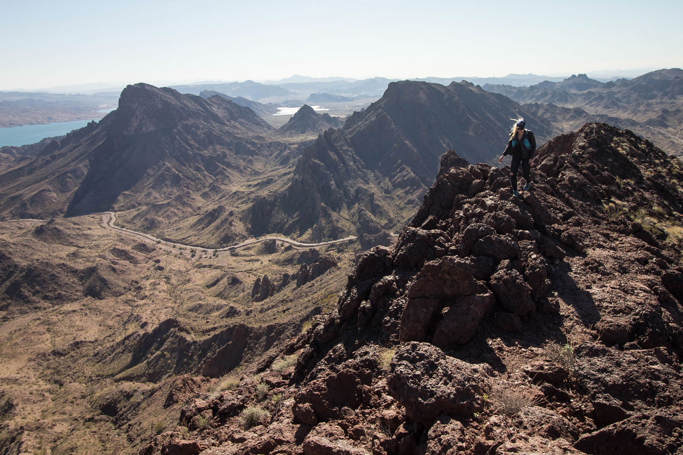
Back at the base of Bundt Butte, we headed to the last peak of the loop, Cherry Top. A steep slope brought us to the base of our intended route, which appeared to be the only weakness on the entire peak. It stands out becaue a diagonal line of brush marks it as something slightly more manageable than just sheer rock. I'll call it a gully, but it barely counts as one. Fortunately, a series of fun Class 3 moves brought us up the initial set of cliff face. A few hundred feet up the gully and some minor route-finding brought us through to a Class 3+ brushy baby canyon with ladder-like holds. This canyon can be avoided by wrapping around to the left, but the scrambling is short and fun. Really fun Class 2/2+ scramblnig led us to the summit of Cherry Top, where we took in the views of the impressive ridgeline and Lake Havasu.
Back at the base of Cherry Top, we noted a well-defined animal trail (from donkeys maybe?) below and headed toward it. It might be tempting to just drop down into the gully at the base of Cherry Top, but I recommend keeping to the left on the way down to avoid sketchy and annoying scrambling, and to take advantage of the lovely animal-made trail. This trail leads north back to Black Meadow Road, which we then followed back to the car. I also need to note how incredibly sheer and impressive Cherry Top looks from the road. This loop was a lot of fun.
Please consider helping me out if you find my site useful. I'm not sponsored, so all site fees are out-of-pocket and my time preparing these trip reports is unpaid. You can also hire me as a web developer. I really appreciate it!


If you find my site helpful, please help me replace my many broken cameras, fund my website fees (hosting, APIs, security), or just support my countless hours of work. I pay for all expenses myself, and all trip reports I post are unpaid and unsponsored, so any support is really appreciated!
If using PayPal, please select their option for "Sending to a friend" so they don't take out fees, thank you.
My site is free to use, but consider sending me a few bucks to help keep it running. Thanks in advance!