

Hope Lake Trailhead.
Along the Hope Lake Trail, a view toward the cliffs surrounding Pilot Knob, center. This is a shot taken at the junction labeled "misguided trail" on my attached map. The end of the loop comes from this creek. The Hope Lake Trail continues on the right.
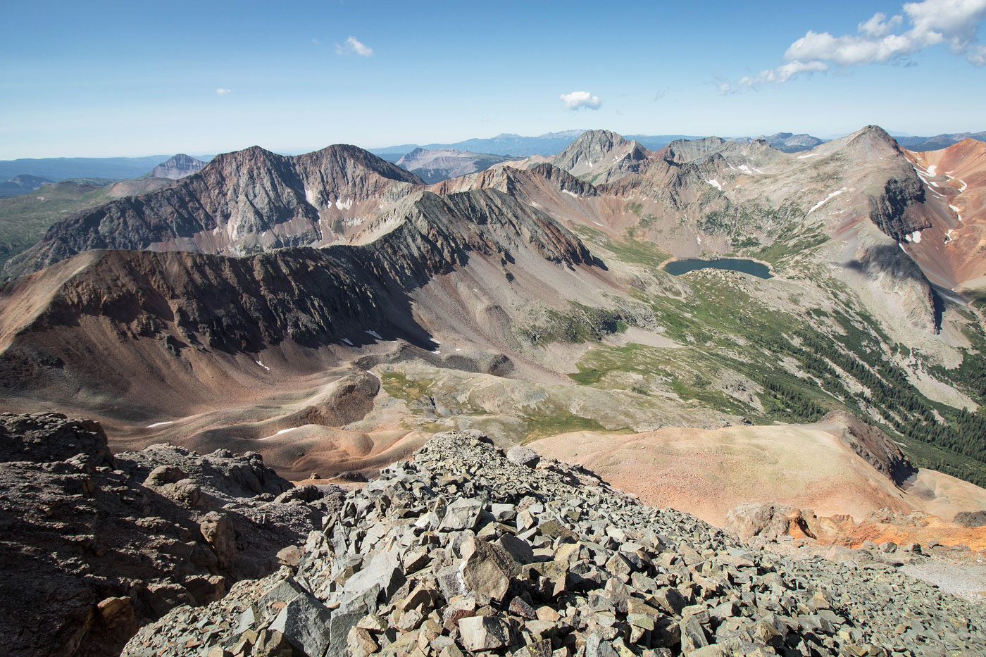
Continuing along the Hope Lake Trail. San Miguel Peak center.
Vermilion Peak looking all pretty and stuff.
Looking back along the Hope Lake Trail before reaching the lake.
Hope Lake. The Mineral Creek Trail continues behind me to the saddle of V8 and V9.
Looking back toward Hope Lake. I know the lighting changed. I took photos at a different time for this section.
Heading up the Mineral Creek Trail to the saddle.
At the saddle, heading up V9 first.
Class 2 to start.
Class 2+/3 on the loose orange crap on the right.
Looking back toward the saddle as the scrambling gets a bit more fun and route-findy.
V9 summit ahead. Wrap around the center outcropping on the left.
Almost on the V9 summit, looking back toward Hope Lake and the V9/V8 saddle.
Last bit to the V9 summit.
V9 summit, view west toward San Miguel Peak.
Back at the saddle of V9 and V8, heading up to V8. Yes, the lighting changed again, but for the last time.
Looking toward Rolling Mountain as I head up V8.
V8 Class 2 talus.
Almost to the V8 summit, looking back toward V9 (left), San Miguel Peak (right top), and Hope Lake.
Continuing along the ridge from V8 to Beattie Peak, Vermilion Peak visible center.
Short Class 2+ loose slope toward the saddle of V8 and Beattie.
Looking back toward the Class 2+ slope at the V8/Beattie saddle.
View back toward V8 as I approach Beattie Peak.
Beattie Peak summit ahead, Fuller Peak on the left.
Another show looking back from the summit of Beattie Peak. San Miguel Peak is the gray one on the right.
Close-up toward Fuller Peak. You can see switchbacks up the ridge, and the shadows hide a more obvious diagonal social trail to the saddle with Vermilion. I took that one. Also note that in case you don't want to descend later from the Vermilion/Golden Horn saddle, there is a social trail at the bottom of this photo that can be used to descend back to Hope Lake.
Along the social trail to the Fuller/Vermilion saddle.
Looking back as I ascend. Beattie Peak on the left.
Just above the Fuller/Vermilion saddle, looking toward Vermilion (left) and Golden Horn (center).
Fuller Peak ahead, Class 2.
Fuller Peak summit, view along the ridgeline toward Beattie. Rolling Mountain visible top left. San Miguel Peak top right.
Back at the Vermilion/Fuller saddle, headed up to Vermilion on a well-beaten social trail.
View back as I start along to Vermilion Peak. Beattie Peak is visible center.
Continuing to Vermilion Peak. The social trail keeps left of the ridge the whole time.
Vermilion Peak summit ahead. Approaching the steep, loose gully (the edge of the shadow) required to gain the summit. Just after the gully, some Class 2 leads to the top.
Looking back as I approach the Vermilion summit gully.
Summit gully. Ew. At the top of this gully, hang left and take some Class 2 stuff to the summit. A short baby knife edge leads to the true summit from there.
Vermilion Peak summit, view north toward Golden Horn (center) and Pilot Knob (left). Ice Lake Basin visible on the right.
Vermilion Peak summit, view toward Fuller Peak and Fuller Lake.
Vermilion Peak summit, view southwest toward my route so far. You can see V9, V8, and Beattie running center to left. Also, Hope Lake and San Miguel on the top right, Rolling Mountain top left.
Close-up toward Hope Lake and San Miguel Peak.
Back at the Fuller/Vermilion saddle, heading along a social trail on Vermilion's eastern slope on Class 2 stuff. The route leads to the Vermilion/Golden Horn saddle.
At the Vermilion/Golden Horn saddle, view toward Golden Horn. Pilot Knob visible in the background.
Class 2/2+ up Golden Horn.
View back toward Vermilion Peak. The bench-like formation where the snow is was the side-hill route I took to get from one saddle to the other.
Golden Horn ahead.
The social trail to Golden Horn leads around the right side of some rocky outcroppings.
Final ascent to the summit.
Golden Horn summit, view north into the Ice Lake Basin.
Close-up toward Pilot Knob.
View back toward Vermilion Peak (right) and Fuller Peak (left). Note the lighter-colored saddle on the bottom right. That's where I decided to descend.
Back at the Vermilion/Golden Horn saddle, looking down the stupid steep slope.
Looking back up at the saddle.
Another shot looking back at the saddle, Golden Horn visible top left.
After continuing past the first steep section, some more Class 2 descending, though far less steep and unpleasant.
Wilson group in the distance.
Looking back at my progress.
Entering the Poverty Gulch drainage, where I encountered a creek.
Looking back again, Pilot Knob's cliffs visible on the left.
Following the creek within Poverty Gulch.
Stumbled on this old trail, labeled "misguided trail".
Continuing along the trail.
Looking back along the trial before rejoining with the Hope Lake Trail.
Hire me or show me some love!
Hire/refer me as a web developer or send me a few bucks if you find my site useful. I’m not sponsored, so all fees are out-of-pocket and my time preparing trip reports is unpaid. I really appreciate it!