

Starting up the Hope Lake Trail.
The trail crosses a creek and continues on the opposite side.
Gorgeous views along the Hope Lake Trail. San Miguel Peak is just right of center.
Close-up of the trail and San Miguel Peak on the right.
Entering the forest, some signs helping to prevent people from going off-trail.
Vermilion Peak visible.
Approaching Hope Lake.
Looking back the way I came.
Hope Lake. I followed the social trail visible on the right.
Continuing around the east side of Hope Lake.
Hope Lake, San Miguel Peak visible center.
View back the way I came along some Class 2 talus as I continue to the north side of Hope Lake.
I crossed over the dam and started ascending the grassy slope. Vermilion Peak visible top right. The Hope Lake Trailhead is somewhere down bottom left within the trees.
Ascending the grassy slopes.
It's hard to tell what's going on in photos, but I recommend just continuing along the grassy slopes and Class 2 stuff.
View down toward Hope Lake, V9 visible top right and Beattie Peak visible top left.
Wider shot of my progress. The route started at the top part of Hope Lake, traversed around its east side, then ascended the slopes on the left in this photo. Vermilion Peak and Beattie Peak visible top.
Continuing up the slopes.
Another shot back to show progress.
Class 2.
San Miguel Peak comes into view.
Class 2, steep and not fun.
View back the way I came, Hope Lake visible on the right.
At the top of the Class 2 at a false summit of San Miguel Peak. You can see Hope Lake in the center, and the two unnamed lakes on the right that I will descend to later.
Continuing along the Class 2 ridge.
At an impassable notch blocking me from the true summit. A route continues just on the right. It's steep and loose.
Looking down at the Class 2+ descent into the notch (notch visible on the left).
Continuing from the notch on Class 2 to the summit of San Miguel Peak.
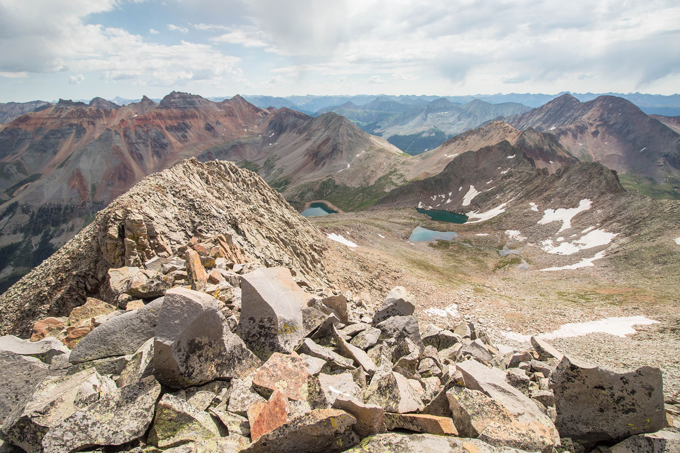
San Miguel Peak, view east. Hope Lake visible center. My chosen descent route leads down to the snowy stuff on the right before continuing to the two unnamed lakes visible to the right of Hope Lake.
Close-up toward Lake Point Peak, an unranked minor summit.
San Miguel Peak, view south the very remote V10 (left) and a possibly taller and more scary summit of San Miguel Peak (right). Further research said it's not taller, fortunately.
Descending from San Miguel Peak toward the lakes. Class 2/3 scrambling on much better quality rock than the ascent.
Approaching the first of the two unnamed lakes. I started getting a little concerned about my route because of the cliffs in the center of this photo, but it ended up only requiring some Class 2.
Pretty lake. Vermilion Peak poking out in the center.
Hope Lake visible below as I leave the basin where the two unnamed lakes live and side-hilled on the grassy slopes. There might be an easier way down from here to get down to Hope Lake, but I was still hoping the weather would clear and I could continue to Vermilion Peak, so I hugged the slopes instead of attempting a route down early.
Looking back toward San Miguel Peak as I continue along the slope.
Looking back along the slopes, Hope Lake visible on the right. You might be surprised to hear that finding a route down to the lake wasn't as easy as expected. It's steep and cliffy.
I was hoping to traverse to the pass visible in the center here in order to go up to Beattie Peak (left) and Vermilion Peak (out of frame, far left), but weather didn't allow it. Instead, I continued along the slope until I could find a good way down.
Class 3 move to get off the slope.
Continuing down to Hope Lake.
View back toward the slope I descended down, the Class 3 move visible in the sunny section left of center. Overall, my descent was lengthier and probably not all that much better than the standard route, but it did serve as a nice alternative route from just going back the same way.
Hire me or show me some love!
Hire/refer me as a web developer or send me a few bucks if you find my site useful. I’m not sponsored, so all fees are out-of-pocket and my time preparing trip reports is unpaid. I really appreciate it!