stav is lost logo
  • Find Hikes
    • Most recent
    • Trip Report Index
    • Hikes by Region
    • Search Hikes
  • Map
  • About
  • Love
Hike Doyle Peak via Weatherford Trail in Coconino National Forest, Arizona - Stav is Lost

Hike Doyle Peak via Weatherford Trail Coconino National Forest, AZ

Class 2 14.8 miles 3400 gain 5-7 hrs Out and Back
Effort
Beauty
Personality
Solitude
DirectionsRoute MapDownload GPX

Doyle Peak via Weatherford Trail GPX Track

I will always provide a free route map, but you can also download a hike/drive GPX to assist you and to help support my site. Before sharing my GPX tracks with others, please remember my site is a free resource and I'm charging nominal fees to offset my substantial costs.

GPX track added to your cart.

Add to Cart ($2.50)
View Cart

Sep 20, 2021 — Doyle Peak is one of the sub-peaks of Humphreys Peak within the San Francisco range north of Flagstaff, Arizona. Since I'd already gotten Agassiz and Fremont via the Inner Basin Trail, I wanted to check out the Weatherford Trail which I'd never hiked before. I knew going into the hike that it would be a long one in terms of distance, but the long and twisting switchbacks meant the hike would be a really light grade and therefore more of a nice forest walk than a difficult hike. The Weatherford Trail was originally constructed as a road to access the high peaks back in the day, but the project was abandoned (thankfully) and now the roadbed remains, creating this trail. Accessing the trailhead is fine for any vehicle.

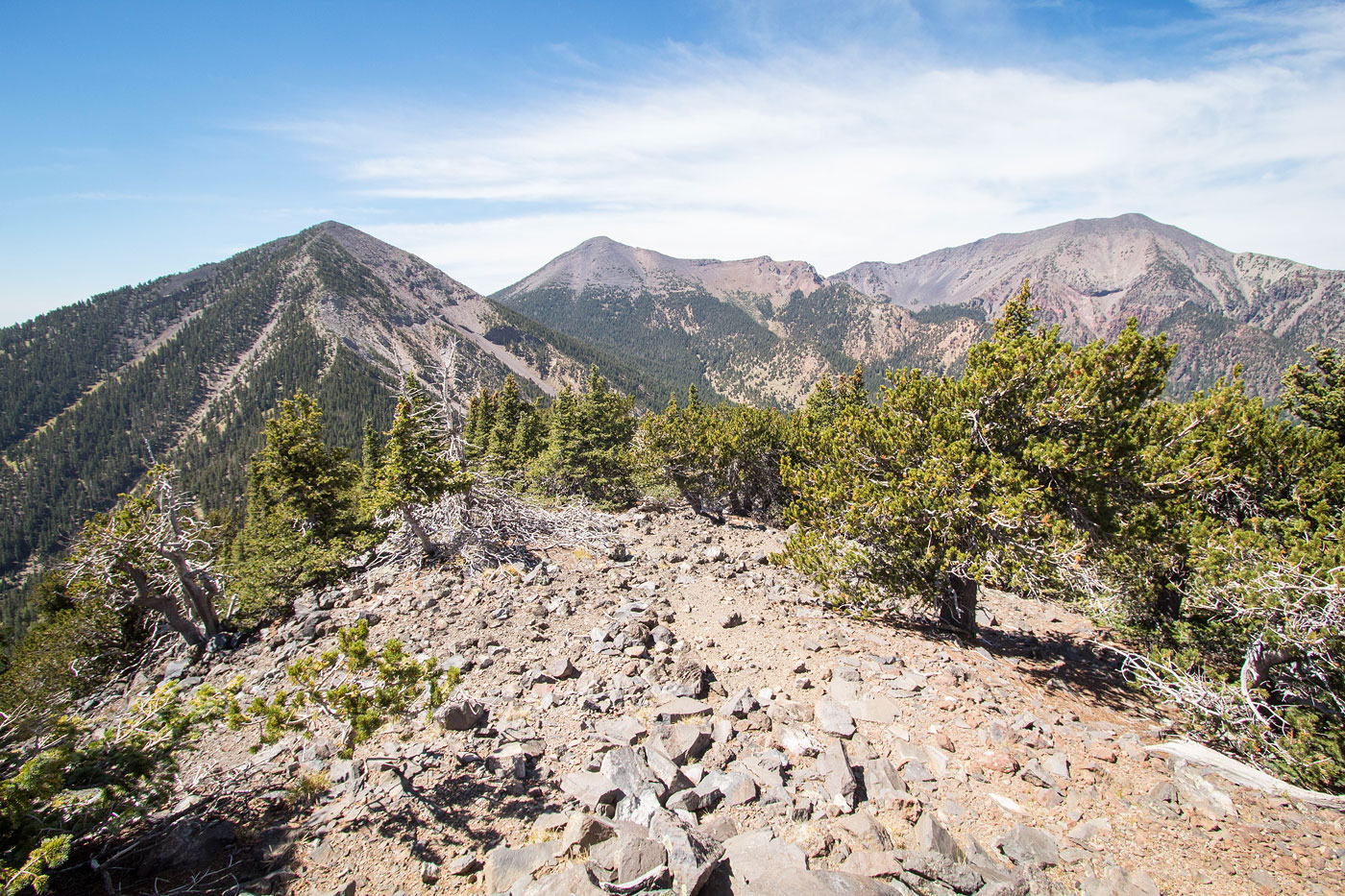
There's not much to note about the very long approach except that it's pretty and the morning sun was really nice. The forest is sparse much of the time and I got nice views to the south. There are also delightful meadows as the trail ascends. You can cut a few of the road switchbacks if you're so inclined to shorten the hike a bit, but I really can't advocate for that. Eventually the trail made its way to Doyle Saddle, where the views became really cool, overlooking the Inner Basin and the taller peaks, including of course Humphreys Peak.

From Doyle Saddle the route got a bit more steep. Hints of a social trail, though not really, led east to the summit of Doyle Peak. The terrain was loose and had some light Class 2. I also found myself slipping a bunch due to the gravelly volcanic nature of the slope. Along the way I passed a little cabin that seems to get at least a little use, though I'm not sure for what. I marked it on my attached map.

You can return the way you came, or get in touch with me for a much nicer descent with light bushwhacking. I left this option off my attached map because it's very different than the quality and personality of the standard Weatherford Trail. A hint is that this other option heads over Schultz Peak. ;)

PEAKS ON HIKE
Elevation (ft) / Prominence (ft)
Peaks on hike
Elevation
Prominence
1
Doyle Peak
11460 ft
660 rise

Show me some love

Please consider helping me out if you find my site useful. I'm not sponsored, so all site fees are out-of-pocket and my time preparing these trip reports is unpaid. You can also hire me as a web developer. I really appreciate it!

Thank you

Next HikePrev Hike
  • Next Hike
  • More Near Here
  • Prev Hike
photo protector Starting along the Weatherford Trail.
Starting along the Weatherford Trail.
photo protector Nice forest walk with some meadows.
Nice forest walk with some meadows.
photo protector No caption.
photo protector Continuing along the southern slopes of the San Francisco Peaks.
Continuing along the southern slopes of the San Francisco Peaks.
photo protector View back through a meadow as I start to get a little higher.
View back through a meadow as I start to get a little higher.
photo protector Entering the Kachina Peaks Wilderness.
Entering the Kachina Peaks Wilderness.
photo protector No caption.
photo protector The Weatherford Trail starts to ascend into switchbacks.
The Weatherford Trail starts to ascend into switchbacks.
photo protector View back.
View back.
photo protector Along the switchbacks, a view toward Schultz Peak to the east.
Along the switchbacks, a view toward Schultz Peak to the east.
photo protector View back as I ascend.
View back as I ascend.
photo protector Still some forested sections, but there are nice views for the majority of the hike up the switchbacks.
Still some forested sections, but there are nice views for the majority of the hike up the switchbacks.
photo protector No caption.
photo protector Fremont Peak comes into view.
Fremont Peak comes into view.
photo protector A switchback along the Weatherford Trail.
A switchback along the Weatherford Trail.
photo protector Making lots of progress.
Making lots of progress.
photo protector No caption.
photo protector Doyle Peak comes into view.
Doyle Peak comes into view.
photo protector No caption.
photo protector Approaching Doyle Saddle. Fremont Peak visible on the left.
Approaching Doyle Saddle. Fremont Peak visible on the left.
photo protector Doyle Saddle. Fremont Peak left, Agassiz Peak center, Humphreys Peak right.
Doyle Saddle. Fremont Peak left, Agassiz Peak center, Humphreys Peak right.
photo protector Doyle Saddle, view up toward Doyle Peak. There's not really enough of a social trail to recommend trying to stick to it. Just head up.
Doyle Saddle, view up toward Doyle Peak. There's not really enough of a social trail to recommend trying to stick to it. Just head up.
photo protector Loose and steep terrain, Class 2.
Loose and steep terrain, Class 2.
photo protector View back down to Doyle Saddle, center. Fremont Peak visible up top.
View back down to Doyle Saddle, center. Fremont Peak visible up top.
photo protector More steep stuff.
More steep stuff.
photo protector Higher up along the ascent.
Higher up along the ascent.
photo protector The terrain mellows out and stays pretty flat for the last few hundred feet to Doyle Peak's summit.
The terrain mellows out and stays pretty flat for the last few hundred feet to Doyle Peak's summit.
photo protector Just before the summit of Doyle Peak a few at the other Kachina Peaks. Fremont Peak left, Agassiz Peak center, Humphreys Peak right.
Just before the summit of Doyle Peak a few at the other Kachina Peaks. Fremont Peak left, Agassiz Peak center, Humphreys Peak right.
photo protector Flattish section to the summit of Doyle Peak.
Flattish section to the summit of Doyle Peak.
photo protector A short side-trip to check out a cabin.
A short side-trip to check out a cabin.
photo protector Inside the cabin.
Inside the cabin.
photo protector Summit of Doyle Peak, close-up toward Humphreys.
Summit of Doyle Peak, close-up toward Humphreys.
photo protector Doyle Peak summit, view toward Fremont Peak left, Agassiz Peak center, Humphreys Peak right.
Doyle Peak summit, view toward Fremont Peak left, Agassiz Peak center, Humphreys Peak right.
photo protector If you want to reach this spot, get in touch. It's a lively little meadow.
If you want to reach this spot, get in touch. It's a lively little meadow.

Show Me Some Love

If you find my site helpful, please help me replace my many broken cameras, fund my website fees (hosting, APIs, security), or just support my countless hours of work. I pay for all expenses myself, and all trip reports I post are unpaid and unsponsored, so any support is really appreciated!

If using PayPal, please select their option for "Sending to a friend" so they don't take out fees, thank you.

PayPalVenmoCash App

About  Contact  Love

© 2023 Stavros Basis.

DISCLAIMER: All activities you find on this site are dangerous. I am not responsible for anything you do in the outdoors. Please practice good ethics, and don't take any risks that put yourself or others in danger.


Thanks for visiting!

My site is free to use, but consider sending me a few bucks to help keep it running. Thanks in advance!

Sure!Nope.