I provide a free route map, but you can also download a hike/drive GPX to assist you and to help support my site. Before sharing my GPX tracks with others, please remember my site is a free resource and I'm charging nominal fees to offset my substantial costs.
GPX track added to your cart.
Jan 29, 2024 — The terrain in the southern portion of the Eagletail Mountains Wilderness is so complex that it completely confuses topographic maps, and is the region that got me hooked on exploring the Eagletails. After yesterday's excellent outing in the central part of the wilderness, it didn't take much to convince my friends to stick around the area for another day. Access is reasonable because there is an official trailhead on this side of the range, and a road has been permitted to tunnel through the wilderness area for a few miles. Despite the existence of this road on some maps past where we parked, continuing farther in a vehicle is illegal. There was a pretty big storm that created concerning deep and muddy puddles that I got through fine, but normally this road would be in pretty decent shape and shouldn't worry anyone with at least a Crossover SUV.
The primary goal for today was Peak 2320, a particularly intense-looking plug lingering on the outskirts of a pinnacle-dominated swath of wonder. I later learned this dark cluster of joy has been colloquially named "The Labyrinth." Peak 2320 is the high point of the Labyrinth. From the wilderness boundary we headed through the desert around an extended finger of this wild clump of desert delights. I tried to contain my excitement for finally checking out this area but also prepared myself for not being able to reach any summits today. Fortunately, that was definitely not the case!
Peak 2320 came into view when we rounded a corner, a majestic tower so daunting that it appears impossible. We figured it would be best approached from its western saddle side since the other aspects of the peak are basically sheer cliffs plunging to the desert floor. We were initially tempted to approach the western saddle from the south, but we figured a short detour to check out the Eagletail Arches wouldn't hurt. Plus, this gave me a reason to procrastinate and thereby ease my anxiety about Peak 2320. As we would find out later, approaching the western saddle from the south would not have been viable anyway, so this was an excellent accidental decision.
A Class 2 wide gully led us up to a series of large windows formed into a nearly sheer face, collectively called Eagletail Arches. The arches are named as such on some maps, but I don't know if this is an official name for them. We took some pictures before getting back to the task at hand. While we could have dropped back to the south and wrapped all the way around to the north side of the saddle, we chose to stay high and attempt a route from Eagletail Arches more directly. This saved us a bunch of elevation gain and added a bit of fun. From the Arches, we took a convenient ledge that ascended slightly and wrapped toward the north side of Peak 2320, where we were confronted with what appeared to be an impossible cliff. With some prodding, we managed to get down this without exceeding Class 3/3+. The solid rock was exposed but didn't really feel it. At the base of this cliff, we merged with where we would have come up had we chosen to fully wrap around.
Now the real fun began, a route-finding extravaganza that challenges some of the greatest desert peaks I've done to date. You'll be tempted to take the wide and obvious gully leading up to the peak's western saddle, but this is not a fruitful mission. I know because I went up there to scout and was confronted with chasm too tight to slide into in order to stem out of. Instead of the main gully, there is a minor chute behind some brush on the left. The rock is surprisingly solid and requires some fun stemming to reach the base of a chockstone. A low Class 5 move is required to overcome this obstacle, and at this point, you are about 20ft off the deck, so it's not a move you should mess up. Watching my friends this had me hesitate for a long time. I had no issue getting to the chockstone, but I had an irrational fear that it would dislodge and squish me. My angel Karson dropped me some webbing so that I could put my weight on that rather than the massive boulder. The moves are not that difficult, but it does require a reach-around that puts you off balance. Coming down later was trivial, somehow.
Past the chockstone, this chute widens slightly and ascends through brushy Class 2+. At the top of this chute, I looked to the left and saw my other friends hanging out on a ledge basically right above us, 50 feet up. There's no way they got there directly from here, so clearly the route zigzagged to provide them access. A slanted ledge provided a short traverse about 30 ft above Peak 2320's western saddle below. It was at this point I realized that reaching this saddle would not have been doable from the south like we had originally intended when planning the day. What a victory it was that we had approached from the north!
Past this ledge, we headed up another short gully and were met with a protruding rib that was covered in solid rock. Class 4 climbing was required here, and a fall would be horrible. Fortunately, there was a tree at the top of this climb that Shawn used to set some webbing for me in case I needed it. On the way up, I did not, but I certainly was happy to have it later on the way down. The moves are fun, and there are plenty of holds, but that exposure wasn't my jam.
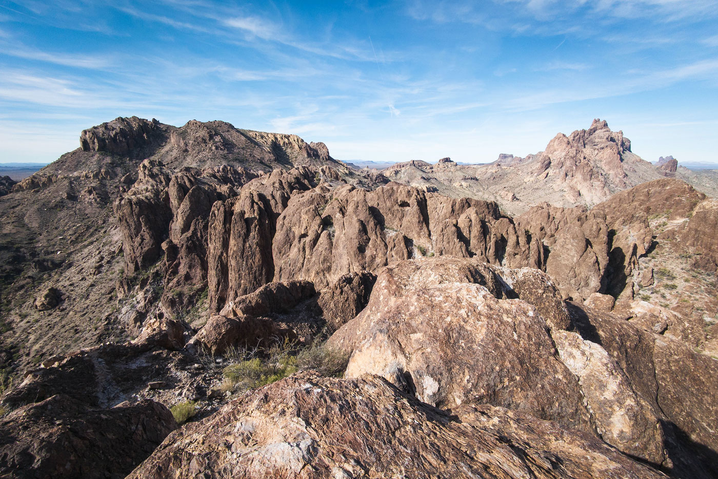
Above the Class 4 section, a short gully led to a notch. We descended from this Class 3 notch into another gully, the spot where I'd seen my friends hanging out from below earlier. We ascended another short gully to another notch. Past here, a unique volcanic slab provided a Class 2 ramp that wrapped around the north side of the peak. The exposure was extreme, but the slab was low angle enough that we could walk across it with just a hand caressing the wall to feel safe. The slab widened into a small clearing surrounded by a cliff band. We located a final short Class 2+ chute to gain the summit. The views toward the Labyrinth and toward the Eagletail Peak were exceptional. There was no indication of a previous ascent. I was overly impressed by the complexity of this route and that it had gone basically non-technically. What a way to start the day!
We backtracked from Peak 2320 and descended to the north into the open desert. Our next goal was Peak 2305, a small and craggy nubbin just below the range high point. It was almost difficult to even make out against the much taller summit due to the way the sun was hitting it, but despite its size it's definitely not a peak to be taken lightly. We passed by an unnamed canyon that cuts through the Labyrinth, and even after plenty of research I haven't been able to find any sort of official name for it. I'll just call it "Labyrinth Canyon". We'd be returning through this canyon on our way back.
We wrapped around to the steepening northern slope of Peak 2305. It was all Class 2 until we reached its cliffy base, where a Class 3 ramp quickly slowed us down. I'm not really sure what my problem was, but I was very scared on this peak. While the route finding was definitely fun, the rock was chunky and loose, and the exposure was pretty severe for pretty much the entire ascent. We headdd up this short ramp above an initial cliff, but now at the base of a ridiculously steep sustained Class 3 slope. We kept our distance from one another. This slope narrowed into a much safer chute and up to a notch on the ridge crest. This was the only time we would be on the ridge crest until reaching the summit because it is otherwise just a jagged spine. A short Class 4 popped us out of the notch and then down a short, eroded ramp. At the base of this ramp it seemed a tall rib would prevent further progress, but an exposed Class 3 move wrapped around this rib into a vertical chasm 100 feet above the desert floor. I couldn't fathom how all three of my friends managed to step across this horrifying chasm without even thinking about it before eventually making the move myself. Once past the chasm, we were confronted with yet another headwall, but a steep Class 2/3 ramp with chunky boulders ascended from the left and above the headwall for about 100 feet all the way to the summit. The perspective toward the high point from here was very cool, but the view toward the Labyrinth was even cooler. What an amazing perch, and honestly a very cool route, despite being excessively dangerous.
I really took my sweet time getting down from Peak 2305, my brain a bit fried from the week's scary route finding and scrambling. Once down, we made it to the mouth of Labyrinth Canyon and headed south into its depths. From what we'd seen from above, we were ridiculously excited to see what this canyon had in store. It was very pretty, but it certainly didn't meet our expectations. The pinnacles didn't quite seem as impressive from below, and the further into the canyon we got, the worse the brush became. At a certain point, the drainage was so choked with brush that it made more sense to avoid it completely. I chose the left slope, which had an animal trail, but was pretty loose overall. My friends kept to the right on steeper rock, which seemed to work just fine as well. The route became a bit convoluted higher up, where we chose to ascend via an interesting little side drainage/canyon that introduced some Class 4 up short dry falls to escape the brush completely. You may be able to keep the ascent out of Labyrinth Canyon easier, but it would likely require a lot more bushwhacking.
Once out of Labyrinth Canyon, Matt and I pushed on west toward Peak 2681. Karson and Shawn had no interest in this one and decided to just head back to the trailhead. Initially, we just headed straight up the Class 2 ridge, but when it became too steep, we followed a wide-sloped ledge that worked its way up to the summit. There might have been a low Class 3 move or two in there somewhere. The sunset views from here were superb, and while not a popular peak by any means, there was a summit register. I spotted some sort of small manmade reservoir far below nestled within The Labyrinth that maybe one day I will go back to inspect. You can absolutely get to this summit more easily than via the bushwhack through Labyrinth Canyon if you don't care to see it, so choose your own adventure.
Rather than backtrack to the saddle, we headed down the major gully leading southeast from the summit. It was an ugly route comprised of some light brush and large boulders spread across a pretty loose slope. We exercised our side-hilling muscles a bit as we formed a descending traverse on more loose terrain once we were out of the gully. From here, we took a drainage that seemed like it would best lead out of the far-reaching fingers surrounding Peak 2681 and back to the cars.
Please consider helping me out if you find my site useful. I'm not sponsored, so all site fees are out-of-pocket and my time preparing these trip reports is unpaid. You can also hire me as a web developer. I really appreciate it!


If you find my site helpful, please help me replace my many broken cameras, fund my website fees (hosting, APIs, security), or just support my countless hours of work. I pay for all expenses myself, and all trip reports I post are unpaid and unsponsored, so any support is really appreciated!
If using PayPal, please select their option for "Sending to a friend" so they don't take out fees, thank you.
My site is free to use, but consider sending me a few bucks to help keep it running. Thanks in advance!