I provide a free route map, but you can also download a hike/drive GPX to assist you and to help support my site. Before sharing my GPX tracks with others, please remember my site is a free resource and I'm charging nominal fees to offset my substantial costs.
GPX track added to your cart.
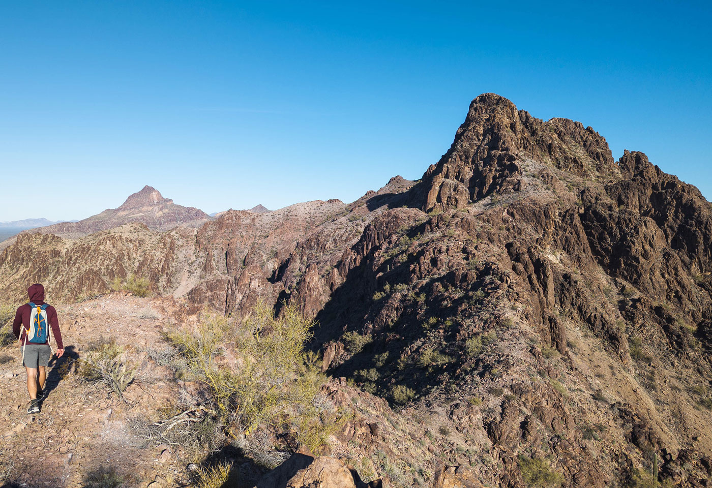
Jan 30, 2024 — The Big Horn Mountains are a small group of Arizona peaks just north of Interstate 10, mostly known for its high point Big Horn Peak. Today, we planned to hike to the high point of the range's southern section, unnamed Peak 2700. From afar, it's a pretty jagged-looking undertaking, a perfect fit for our last day of a desert scrambling trip. Without any information about reaching the summit, we tried to locate a road that might get us close to the high point. The land to the south of the Big Horn Mountains Wilderness is tricky to access since a water canal snakes around it, but we managed to find a legal way to access this part of the range when approaching from the southeast. Whether you're coming from the east or west on the I-10, navigate to here (33.49819, -113.02773) and head north, under I-10. Continue west here (33.56114, -113.05372). The road is in great condition, maintained for access to the canal and power lines overhead. It's likely passable by passenger vehicles.
We parked at a locked gate and decided that the southern ridge of Peak 2700 looked far more fun than just walking through the flat desert to the base of the peak. Although the ridge was a bit lumpy, we were happy with our decision. Overall, this ridgeline route included lots of Class 2 and occasional wraps around outcroppings along the crest. There was one required Class 3 down-climb into a notch, but otherwise, most of the scrambling isn't notable. At one point, my friends stuck to the sketchier crest outcroppings just for fun while I chose to sidehill. They seemed to enjoy themselves, but I was content to skip additional dangers. In fact, one of them knocked a massive boulder off that, had we not been communicating better as to my whereabouts below them, would have wrecked me. Another benefit of taking the ridge is that we got a really nice view of Peak 2700 ahead when it became clear that the southern aspect was not a viable ascent option.
We hiked a steep slope to the peak's base and wrapped around its east side, sidehilling on reasonable terrain. We headed up a steep Class 2 gully that ultimately leads to a minor saddle just north of the summit. You don't want to take this gully all the way there though, since the summit is not accessible from this saddle. Instead, about 50 feet below the crest, a smaller gully on the left leads up to a chimney. I would call this chimney low Class 5, but it isn't exposed. Surprisingly, all the holds I wanted were there, and they were quite solid. I chose to take this route, while my friends decided on a more exposed Class 4 face. I descended their way on the way back and was not happy with that decision, certainly preferring the more technical chimney compared to the more dangerous, but technically easier option. So, a Class 4 route exists, though I didn't document or take photos of it. You can locate it about 100 feet left and below the chimney I used. Anyway, from the top of the chimney I followed the Class 2/3 ridge crest to the summit of Peak 2700.
After backtracking to the south side of Peak 2700 again, we decided to save time and just make a loop rather than return via the eventful crest approach. This required taking a steep and loose Class 2 slope down to the desert floor, some talus along the way. The closer we got to the cars, the better the terrain became, eventually all rockiness left behind. I got a tiny rock stuck in my brake during the drive back, creating a shrill so loud that it concerned even the brake repair guy when I pulled up to get it checked out. A minor annoyance, but who knew a little rock could be so loud? I said farewell to my friends after this excellent streak of tough desert adventures.
Please consider helping me out if you find my site useful. I'm not sponsored, so all site fees are out-of-pocket and my time preparing these trip reports is unpaid. You can also hire me as a web developer. I really appreciate it!


If you find my site helpful, please help me replace my many broken cameras, fund my website fees (hosting, APIs, security), or just support my countless hours of work. I pay for all expenses myself, and all trip reports I post are unpaid and unsponsored, so any support is really appreciated!
If using PayPal, please select their option for "Sending to a friend" so they don't take out fees, thank you.
My site is free to use, but consider sending me a few bucks to help keep it running. Thanks in advance!