stav is lost logo
  • Find Hikes
    • Most recent
    • Trip Report Index
    • Hikes by Region
    • Search Hikes
  • Map
  • About
  • Love
Hike Hell's Half Acre: Y L Canyon and Maple Canyon in Hell's Half Acre, New Mexico - Stav is Lost

Hike Hell's Half Acre: Y L Canyon and Maple Canyon Hell's Half Acre, NM

Class 2 10.2 miles 1800 gain 4-6 hrs Out and Back
Effort
Beauty
Personality
Solitude
DirectionsRoute MapDownload GPX

Hell's Half Acre: Y L Canyon and Maple Canyon GPX Track

I will always provide a free route map, but you can also download a hike/drive GPX to assist you and to help support my site. Before sharing my GPX tracks with others, please remember my site is a free resource and I'm charging nominal fees to offset my substantial costs.

GPX track added to your cart.

Add to Cart ($3.50)
View Cart

Oct 16, 2020 — Hell's Half Acre is a weird little series of slot canyons and conglomerate rock features just north of Silver City, put on my radar from Doug Scott Art's website. He has done extensive exploration of the side-canyons, and I was hoping to mimic parts of his route. However, I underestimated the difficulty of the route and ran out of water, and for a bunch of other silly reasons I only got to check out one of the major highlights of the area, Maple Canyon. It's also a very remote area that likely gets very little visitation, so plan accordingly. Slot canyons are dangerous, even nontechnical ones. The approach road was in great shape for any vehicle, and I parked at a small pull-out. I was a little confused at the private property boundaries of the area since everything seemed to be boxed off with fences. However, some research later helped me conclude what portion is officially on private land (purple line on my map). I can't imagine the ranchers would mind a hiker strolling through, but I recommend taking the orange line to get into Hell's Half Acre instead. It's definitely more efficient and keeps away from what I believe is the private property boundary. This approach involves hiking along a mesatop, descending on some light Class 2 boulders, and continuing through grasses down into the major canyon that runs through Hell's Half Acre, "Y L Canyon".

Once in Y L Canyon, I headed through the obvious winding drainage that slowly became more interesting. The walls grew taller and more imposing, and lots of side-canyons popped out from either direction. Most looked brushy and uninviting. Y L Canyon eventually opened up, and shortly after I left the main drainage and ascended a brushy side-canyon to get over to the northern portion of Hell's Half Acre (marked on the attached map). This involved hiking up a steep, loose slope to a gain a high point, then dropping down to the north in another brushy canyon. From here, I was in the heart of Hell's Half Acre, where the sky seems to be the limit in exploring the area. I may have to return to see more at some point in my life, but I was happy with the introduction I got to see. I ended up doing a bit of bushwhacking and ultimately ended up with a bit of poison ivy/oak.

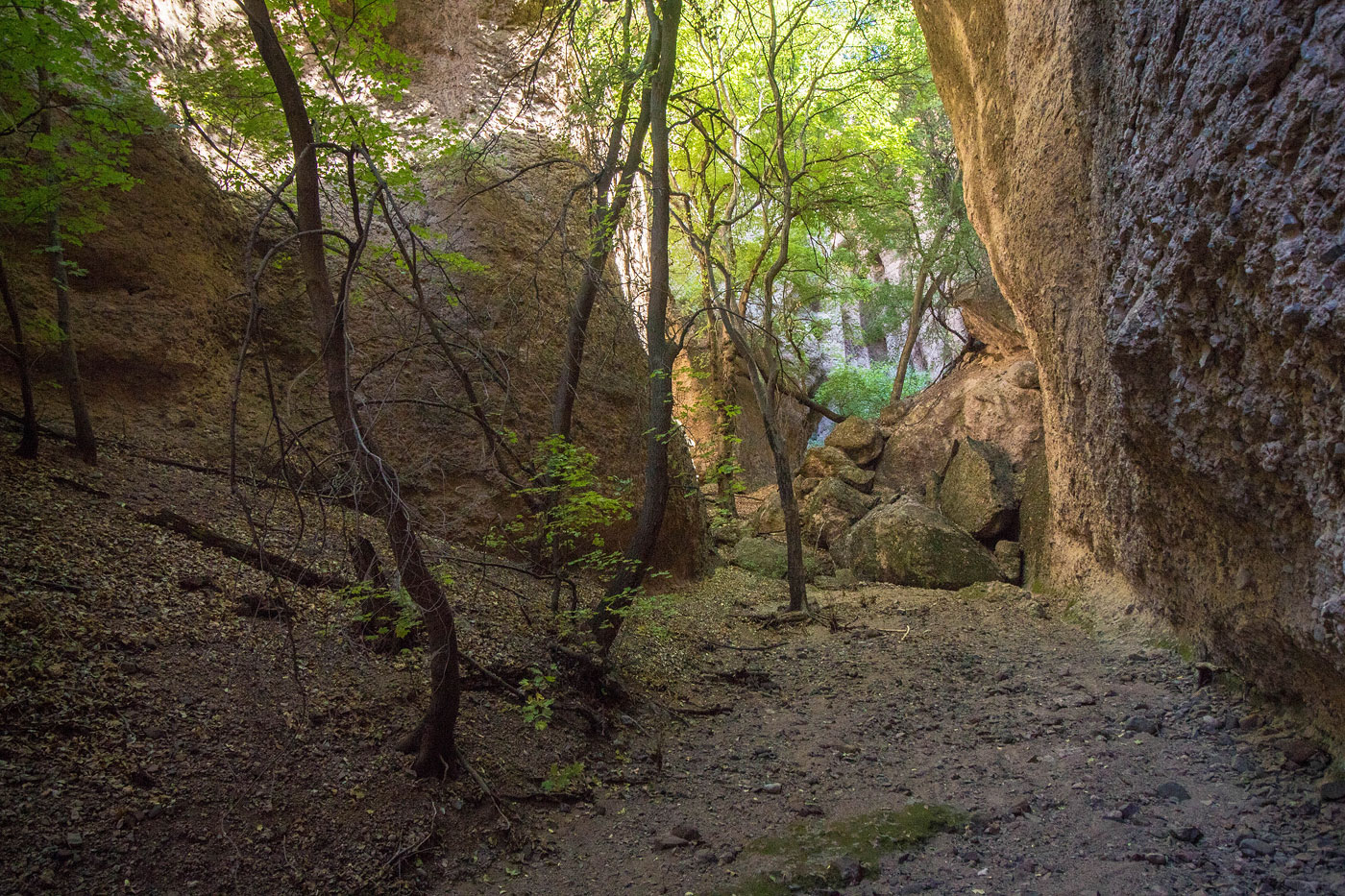
I followed Doug Scott's map and found myself in Maple Canyon, a very cozy box canyon with maple trees growing between hanging cliff walls. The lighting was surreal and I felt very isolated. I followed Maple Canyon to its end, hoping to be able to scramble out, but was stopped by a dryfall at each of my attempts. I returned the way I came instead, leaving behind the many conglomerate slot canyons for another person to explore. I did attempt another side-canyon, but I saw kitty cat prints leading into the canyon, and none coming back out, so I played it safe and nixed the idea.

Show me some love

Please consider helping me out if you find my site useful. I'm not sponsored, so all site fees are out-of-pocket and my time preparing these trip reports is unpaid. You can also hire me as a web developer. I really appreciate it!

Thank you

Next HikePrev Hike
  • Next Hike
  • More Near Here
  • Prev Hike
photo protector Starting along the mesa, where I followed the fence line, keeping to the right of it.
Starting along the mesa, where I followed the fence line, keeping to the right of it.
photo protector Along the mesatop.
Along the mesatop.
photo protector Looking to the south toward the approach canyon options that runs through private property.
Looking to the south toward the approach canyon options that runs through private property.
photo protector Dropping off the mesa and heading toward Hell's Half Acre, which you can see on the right.
Dropping off the mesa and heading toward Hell's Half Acre, which you can see on the right.
photo protector Looking back toward the mesa descent.
Looking back toward the mesa descent.
photo protector Approaching Y L Canyon.
Approaching Y L Canyon.
photo protector Y L Canyon below.
Y L Canyon below.
photo protector No caption.
photo protector If for some weird reason you don't want to take my advice and do the mesatop approach instead of the private property canyon approach, this is what the descent from the trailhead would look like.
If for some weird reason you don't want to take my advice and do the mesatop approach instead of the private property canyon approach, this is what the descent from the trailhead would look like.
photo protector Private property alternative approach: this is the canyon.
Private property alternative approach: this is the canyon.
photo protector Private property alternative approach: this is more of the canyon. It's brushy and you should avoid it on the left slickrock
Private property alternative approach: this is more of the canyon. It's brushy and you should avoid it on the left slickrock
photo protector Private property alternative approach: a fence marking the end of the private property. Seriously, the mesatop approach was better.
Private property alternative approach: a fence marking the end of the private property. Seriously, the mesatop approach was better.
photo protector Either approach leads into Y L Canyon, here.
Either approach leads into Y L Canyon, here.
photo protector Gorgeous rock features.
Gorgeous rock features.
photo protector No caption.
photo protector One of the taller cliff faces within Y L Canyon.
One of the taller cliff faces within Y L Canyon.
photo protector No caption.
photo protector Some old dam just off of Y L Canyon.
Some old dam just off of Y L Canyon.
photo protector No caption.
photo protector After Y L Canyon begins to open up, I left it (Y L Canyon visible on the right) and headed up a steep slope. This shot is looking back the way I came.
After Y L Canyon begins to open up, I left it (Y L Canyon visible on the right) and headed up a steep slope. This shot is looking back the way I came.
photo protector At the top of the steep slope, looking down into the canyon I would descend in order to access Maple Canyon.
At the top of the steep slope, looking down into the canyon I would descend in order to access Maple Canyon.
photo protector Descent into the norther portion of Hell's Half Acre.
Descent into the norther portion of Hell's Half Acre.
photo protector Navigating some of the canyons to locate Maple Canyon.
Navigating some of the canyons to locate Maple Canyon.
photo protector A small side canyon.
A small side canyon.
photo protector No caption.
photo protector Pretty section of side canyon.
Pretty section of side canyon.
photo protector Maple Canyon begins.
Maple Canyon begins.
photo protector Very cozy and pretty within Maple Canyon.
Very cozy and pretty within Maple Canyon.
photo protector No caption.
photo protector Maple Canyon continues, but it's just a bunch of rock-hopping and fun bouldery moves through talus caves, ultimately ending in a dryfall.
Maple Canyon continues, but it's just a bunch of rock-hopping and fun bouldery moves through talus caves, ultimately ending in a dryfall.

Show Me Some Love

If you find my site helpful, please help me replace my many broken cameras, fund my website fees (hosting, APIs, security), or just support my countless hours of work. I pay for all expenses myself, and all trip reports I post are unpaid and unsponsored, so any support is really appreciated!

If using PayPal, please select their option for "Sending to a friend" so they don't take out fees, thank you.

PayPalVenmoCash App

About  Contact  Love

© 2023 Stavros Basis.

DISCLAIMER: All activities you find on this site are dangerous. I am not responsible for anything you do in the outdoors. Please practice good ethics, and don't take any risks that put yourself or others in danger.


Thanks for visiting!

My site is free to use, but consider sending me a few bucks to help keep it running. Thanks in advance!

Sure!Nope.