I provide a free route map, but you can also download a hike/drive GPX to assist you and to help support my site. Before sharing my GPX tracks with others, please remember my site is a free resource and I'm charging nominal fees to offset my substantial costs.
GPX track added to your cart.
Feb 21, 2024 — The Mid Hills High Point is an interesting cluster of granitic rock atop an otherwise lumpy and undulating desert landscape within Mojave National Preserve. It's a bit of an uninspired region, but it's always nice to explore a seldom-visited peak, especially when it has an excellent string of interesting moves to gain the summit. Chris and I drove on Cedar Canyon Road, passable by any vehicle. We parked at a pull-out and started up the remains of an old road. This deteriorated fully, and we entered a sandy wash that very gradually ascended through a pretty canyon, the sides steep enough that we felt a little enclosed. We even encountered some flowing water on slickrock.
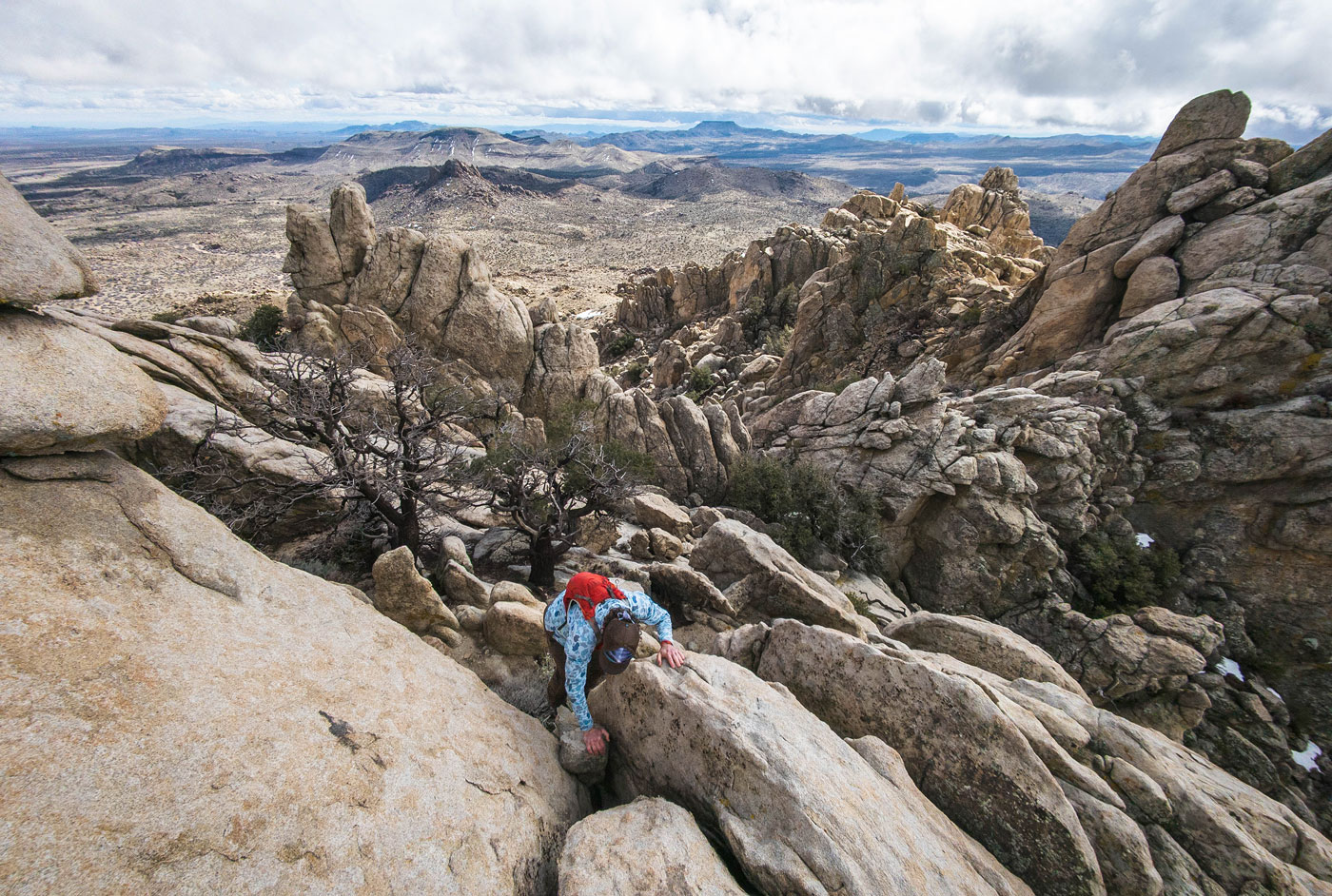
The wash exited the canyon, and we were awarded views to, well, lumpy desert terrain. Still within the wash, we followed its course until it became less defined since we were nearing its head, and it made sense to pick our way out of it and onto the gentle slopes through a burn area to the base of Mid Hills High Point, marked by a sudden chunky wall of granite. It made the most sense to keep to the right and side-hill a bit to avoid the majority of the boulders, but you could add some scrambling if you decide to stay amongst them. It wasn't super clear where the high point was from here since there were a series of contenders that appeared similar in height from below, but we chose well and ended up at its base. We snuggled up to a cactus between two faces, pulling a short Class 3 move, then ascended a slabby portion on the southwest side of the peak and wrapped around on a series of fun Class 2/3 moves to gain the summit crest. The summit was just ahead, but the Class 4 crux came first: a huge chunk of granite slab barely separated from the summit, but forming a nice crack. Chris preferred to use the crack created by the slab, while I chose to use the face, which had a massive horizontal crack I could use. There was some slightly more exposed, but only Class 3 scrambling above this. The summit had nice views of the New York Mountains and the otherwise pretty flat desert below.
Our sight was now set on a series of lumps to the southeast, the tallest of them named Pinto Mountain. It was really, truly nothing to be desired as far as peaks go. Chris mocked the generic name, "It's not even in the top 50 best Pinto Mountains!" But, we figured we were out here already, so why not? It never hurts to add on another peak. We backtracked to the wash we'd hiked along, then exited the steep bank to hike cross-country to the base of Pinto Mountain. Aside from a small cliff band tower at the peak's base that we wrapped around on the left, this was a grassy and trivial summit, though steep.
Rather than backtrack, we figured we'd try to descend via the southern side of Pinto Mountain. On our way down, we encountered a rocky cliff band that was surprisingly steep, but we pretty quickly found a down-climb at Class 2/3. Once below this obstacle, we hiked through open desert again, passed under a barbed wire fence, and returned to Cedar Canyon Road.
Please consider helping me out if you find my site useful. I'm not sponsored, so all site fees are out-of-pocket and my time preparing these trip reports is unpaid. You can also hire me as a web developer. I really appreciate it!


If you find my site helpful, please help me replace my many broken cameras, fund my website fees (hosting, APIs, security), or just support my countless hours of work. I pay for all expenses myself, and all trip reports I post are unpaid and unsponsored, so any support is really appreciated!
If using PayPal, please select their option for "Sending to a friend" so they don't take out fees, thank you.
My site is free to use, but consider sending me a few bucks to help keep it running. Thanks in advance!