stav is lost logo
  • Find Hikes
    • Most recent
    • Trip Report Index
    • Hikes by Region
    • Search Hikes
  • Map
  • About
  • Love
Hike Mount Hatten and Crater Peak in Grand Mesa National Forest, Colorado - Stav is Lost

Hike Mount Hatten and Crater Peak Grand Mesa National Forest, CO

Class 2 9.8 miles 2400 gain 3-5 hrs Out and Back
Effort
Beauty
Personality
Solitude
DirectionsRoute MapGPX

Mount Hatten and Crater Peak GPX Track

I will always provide a route map for free, but you can also download a hike/drive GPX track of this route to assist on your outing and to help support my site. Before sharing my tracks with others, please remember my site is a free resource and I'm charging nominal fees for GPX tracks in an attempt to offset my substantial website costs.

GPX track added to your cart.

Add to Cart ($2.50)
View Cart

Jul 27, 2023 — After spending the last many months at lower elevations, I decided sub-13ers would be a good way to start my Colorado peakbagging bender. The result was a remote summit on the Grand Mesa called Crater Peak, plus its only slightly shorter companion Mount Hatten. Grand Mesa is most known for the lake-dotted volcanic landscape that includes hikes like the Crag Crest Loop farther west, but I was interested in the high point of the area today in the lesser-visited eastern region. Any car can make it to where I started the hike, and Crossover vehicles could likely even reach the 4WD parking lot at Goodenough Reservoir at the end of the road here (39.03809, -107.68034). However, I didn't want to risk car damage on day one, so I was content to enjoy the more extended hike by starting the day with a road walk.

My long drive the day before with an embarrassing number of pitstops got me to bed too late, which led me to wake up late. Groggy, I emerged from my car to a swarm of mosquitoes. The anticipated summer heatwave was clearly in full swing as well, but lightweight body armor was my only option to avoid getting eaten alive on this hike. I started along the rocky road, already sweating before taking my first steps, swatting my face regularly to ward off mosquitoes. At least the wildflowers were blooming gloriously.

The first few miles were uneventful road walking that meandered past a cabin (possibly occupied?) and through pretty meadows. I passed a couple of locals who had hiked to Crater Peak before and informed me there's sort of a trail leading up through the forest and to the ridgeline. Apparently difficult to locate, I decided to make Mount Hatten my first objective since once I was along the ridge crest it would be easier to locate the elusive trail. The issue here is that the southern base of Crater Peak and Mount Hatten is riddled with bogs and reservoirs, so I thought it best to use a pre-established route to get as close to the peaks as I could. Fortunately, I reached an old junction with a now-closed road and decided this would be a suitable route for reaching the base of Mount Hatten, which was now very much in view ahead. I passed the small Pine Cone Reservoir on its west side, noting a social trail that wrapped around its north side. I'd later use that social trail on my way back, but for now I continued off-trail up a steep and grassy slope to the west ridge of Mount Hatten. Despite the steepness, the bushwhacking was nearly nonexistent and there was even an animal trail leading along the ridge to the summit.

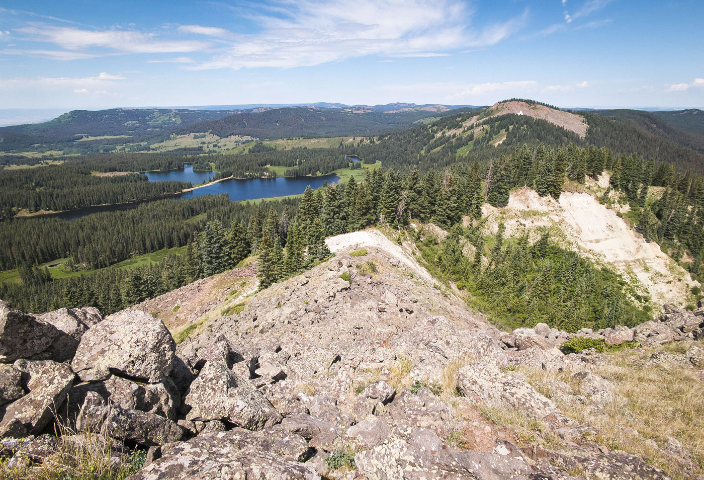
Mount Hatten had some nice views toward the reservoirs below, but the mosquitos managed to find me up here too, so I was forced onward. A short spurt of Class 2 on loose volcanic terrain brought me down Mount Hatten's east ridge, and then I was walking easily along the forested ridgeline. I stumbled on a narrow trail, which I realized was the trail the couple had mentioned earlier. I took note of where it bent off the ridge for my way back, and continued along it toward Crater Peak. The now-trailed ridge walk went quickly and was easy to follow until reaching a small talus field. Past here I chose to keep to the crest to gain Crater Peak since the ridge was colorful and eroded and looked very cool. There were some tree obstacles along the crest, so you may want to keep just below and to the right to avoid it. Class 2 talus led me to the summit, where I tried to brave the annoying insects, but opted to skip hiking to nearby unranked Mount Darlene.

I backtracked along the social trail and followed it down off the ridge. While in the forest, this trail is very easy to follow, but once I emerged into the meadows surrounding the reservoirs I quickly lost it. I did my best to stick to higher ground to avoid the boggy mess, ultimately finding my way back to the Pine Cone Reservoir where I located another social trail that took me to the old abandoned road/trail that I had come in on and then back to the approach road.

PEAKS ON HIKE
Elevation (ft) / Prominence (ft)
Peaks on hike
Elevation
Prominence
1
Mount Hatten
11310 ft
470 rise
2
Crater Peak
11327 ft
2287 rise

Show me some love

Please consider helping me out if you find my site useful. I'm not sponsored, so all site fees are out-of-pocket and my time preparing these trip reports is unpaid. You can also hire me as a web developer. I really appreciate it!

Thank you

Next HikePrev Hike
photo protector I started on foot along the initially good dirt road, passing this domicile.
I started on foot along the initially good dirt road, passing this domicile.
photo protector Mount Hatten seen in the distant center, wildflower-filled meadows everywhere.
Mount Hatten seen in the distant center, wildflower-filled meadows everywhere.
photo protector View back as I progress along the pretty road walk.
View back as I progress along the pretty road walk.
photo protector The Crater Peak ridgeline seen ahead.
The Crater Peak ridgeline seen ahead.
photo protector View back as I approach the junction with the old, closed road.
View back as I approach the junction with the old, closed road.
photo protector Mount Hatten poking out behind the swampy landscape at its base.
Mount Hatten poking out behind the swampy landscape at its base.
photo protector Junction with the old, closed road. I kept left here.
Junction with the old, closed road. I kept left here.
photo protector An old trail leads toward the base of Mount Hatten.
An old trail leads toward the base of Mount Hatten.
photo protector Passing by Pine Cone Reservoir, Mount Hatten seen above.
Passing by Pine Cone Reservoir, Mount Hatten seen above.
photo protector View across Pine Cone Reservoir toward Crater Peak.
View across Pine Cone Reservoir toward Crater Peak.
photo protector Continuing up the progressively steepening slope to gain Mount Hatten's west ridge.
Continuing up the progressively steepening slope to gain Mount Hatten's west ridge.
photo protector Mostly just grassy, minimal brush.
Mostly just grassy, minimal brush.
photo protector I reached the west ridge, the reservoirs visible below.
I reached the west ridge, the reservoirs visible below.
photo protector Ascending to Mount Hatten.
Ascending to Mount Hatten.
photo protector View back along the ridgeline just below the summit of Mount Hatten.
View back along the ridgeline just below the summit of Mount Hatten.
photo protector Mount Hatten summit, view north.
Mount Hatten summit, view north.
photo protector Mount Hatten summit, view east toward Crater Peak (left) and Goodenough Reservoir (center). I started down the steep, short, volcanic slope along the ridge.
Mount Hatten summit, view east toward Crater Peak (left) and Goodenough Reservoir (center). I started down the steep, short, volcanic slope along the ridge.
photo protector Close-up toward the descent and Crater Peak on the left.
Close-up toward the descent and Crater Peak on the left.
photo protector View back up toward Mount Hatten.
View back up toward Mount Hatten.
photo protector A pleasant forest walk without any brush for a short time.
A pleasant forest walk without any brush for a short time.
photo protector I then stumbled on the social trail people seem to use for Crater Peak.
I then stumbled on the social trail people seem to use for Crater Peak.
photo protector The trail was narrow, but easy to follow most of the way to Crater Peak.
The trail was narrow, but easy to follow most of the way to Crater Peak.
photo protector Beautiful forested ridge to Crater Peak.
Beautiful forested ridge to Crater Peak.
photo protector View back as I ascend to Crater Peak.
View back as I ascend to Crater Peak.
photo protector The trail disappears at this small talus field.
The trail disappears at this small talus field.
photo protector I kept mostly to the ridge crest to gain the summit seen ahead, but there were some trees, so it might make sense to keep farther below and to the right.
I kept mostly to the ridge crest to gain the summit seen ahead, but there were some trees, so it might make sense to keep farther below and to the right.
photo protector Approaching Crater Peak.
Approaching Crater Peak.
photo protector Crater Peak summit, view back toward Mount Hatten.
Crater Peak summit, view back toward Mount Hatten.
photo protector Crater Peak summit, view south toward Mount Darlene.
Crater Peak summit, view south toward Mount Darlene.
photo protector Close-up toward Goodenough Reservoir.
Close-up toward Goodenough Reservoir.
photo protector I backtracked along the trail and then headed down using the social trail.
I backtracked along the trail and then headed down using the social trail.
photo protector It began very easy to follow, but once it exited the forest was unclear.
It began very easy to follow, but once it exited the forest was unclear.
photo protector View back toward the ridge I came down from.
View back toward the ridge I came down from.
photo protector I wandered on higher ground to avoid the swampy terrain after losing the trail.
I wandered on higher ground to avoid the swampy terrain after losing the trail.
photo protector And then I located another social trail that took me back to the north side of Pine Cone Reservoir, completing my little loop. I then made my way back to the car.
And then I located another social trail that took me back to the north side of Pine Cone Reservoir, completing my little loop. I then made my way back to the car.
photo protector Goodenough Reservoir, which I added as a quick detour, but didn't include in my hike stats/map.
Goodenough Reservoir, which I added as a quick detour, but didn't include in my hike stats/map.

Show Me Some Love

If you find my site helpful, please help me replace my many broken cameras, fund my website fees (hosting, APIs, security), or just support my countless hours of work. I pay for all expenses myself, and all trip reports I post are unpaid and unsponsored, so any support is really appreciated!

If using PayPal, please select their option for "Sending to a friend" so they don't take out fees, thank you.

PayPalVenmoCash App

About  Contact  Love

© 2023 Stavros Basis.

DISCLAIMER: All activities you find on this site are dangerous. I am not responsible for anything you do in the outdoors. Please practice good ethics, and don't take any risks that put yourself or others in danger.


Thanks for visiting!

My site is free to use, but consider sending me a few bucks to help keep it running. Thanks in advance!

Sure!Nope.