stav is lost logo
  • Find Hikes
    • Most recent
    • Trip Report Index
    • Hikes by Region
    • Search Hikes
  • Map
  • About
  • Love
Hike Mountain Boy Peak in White River National Forest, Colorado - Stav is Lost

Hike Mountain Boy Peak White River National Forest, CO

Class 2 6.5 miles 1900 gain 3-5 hrs Out and Back
Effort
Beauty
Personality
Solitude
DirectionsRoute MapDownload GPX

Mountain Boy Peak GPX Track

I will always provide a free route map, but you can also download a hike/drive GPX to assist you and to help support my site. Before sharing my GPX tracks with others, please remember my site is a free resource and I'm charging nominal fees to offset my substantial costs.

GPX track added to your cart.

Add to Cart ($2.50)
View Cart

Aug 05, 2023 — For the second time this year my friend Jason roped me into running a race with him, this time in Aspen CO. Although I dreaded spending any time in the fancy little money town, we ended up having a lot of fun and were done by mid-morning. After learning that Jason had never been to Colorado before and with most of a day to kill, I very firmly suggested we bag a peak. I was happily surprised he didn't push back, so off we went to Independence Pass for a quick outing, both of us psyched to add more mileage to our caffeine-fueled post-race legs. Mountain Boy Peak is a 13er just south of the pass, so we weren't surprised to see our trail ahead dotted with hikers. Most of them were headed to the first bump along the trail to get a slightly better view, while fewer ventured farther to Igloo Peak, an unranked lump just over 13,000 feet. Mountain Boy Peak's summit itself sees far fewer visitors for reasons that would become apparent to us soon.

The first mile or so follows an old doubletrack road converted to trail, narrowing to singletrack as it ascends slowly up to a false summit of Igloo Peak. After a dip along the ridgeline we were ascending to Igloo Peak. Along the way we passed some cool volcanic rocks just on the north side of Igloo Peak, but the trail wraps around them without difficulty. On the summit of Igloo Peak, I assured Jason there was still more to come, but I had neglected to research what the approach for Mountain Boy Peak would be like. Put plainly, the terrain to get down from Igloo Peak was garbage.

We started directly east off Igloo Peak on Class 2+ terrain with some light exposure. The crest became a loose mess, but a social trail led us south through some deep scree. We wanted to get back to the ridge as soon as possible, but we wanted to first avoid a particularly steep section of hardpan slope, so we continued descending along this scree trail until an easier move avoided the sketchier stuff. A faint social trail contoured us to the saddle separating Igloo Peak from Mountain Boy Peak. I felt bad. This was Jason's first peak in CO, so I hoped it wouldn't leave a poor impression, but he assured me it was fine and a cool experience. I vowed to try to find a better route on the way back.

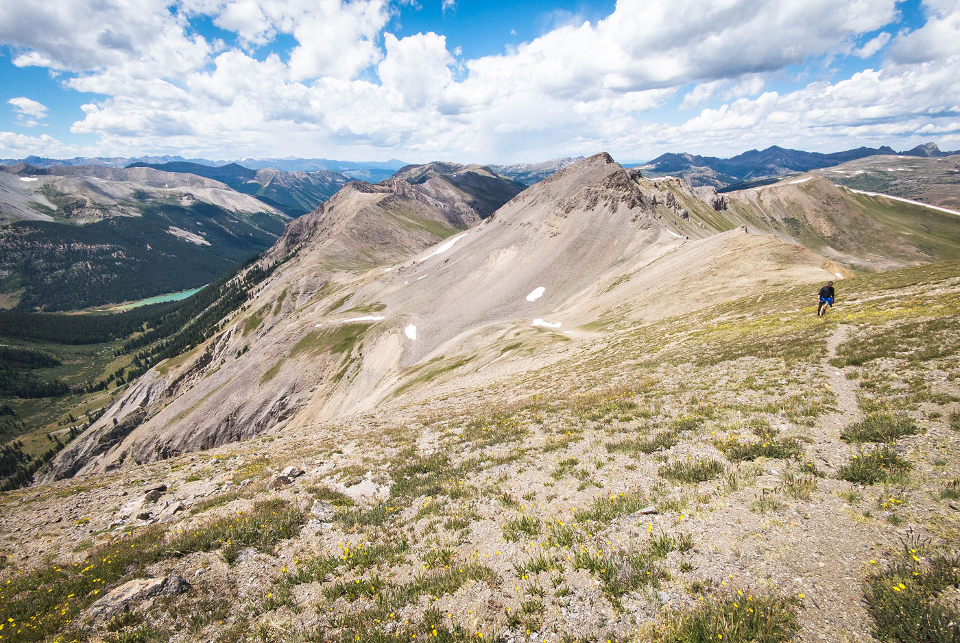
A social trail continued toward Mountain Boy Peak, ascending diagonally along its western slope. We enjoyed the views toward the looming Grizzly Peak and down toward the bright Grizzly Reservoir. At a certain point the trail didn't seem to be ascending quite to the summit, so we headed up the tundra to Mountain Boy Peak. Unfortunately, I had to interrupt our summit enjoyment due to an approaching dark cloud, despite Jason's clear excitement for the stellar views.

We backtracked to the saddle. I noted that we could just drop off the ridge and use the tundra on the northeast side of Igloo Peak to return, but a social trail piqued my curiosity. It led just below the steep nonsense of Igloo Peak's north face. Rather than drop significant elevation, we agreed to try this route. Overall it was far better than our descent from Igloo Peak earlier, but still not much fun. The slope was angled steeply enough that it felt dangerous at times, and the social trail wasn't defined enough for us to feel confident the route would lead us safely back to the ridge, but it did. A couple of steeper sections pushed us into Class 2+ territory. It wasn't really scrambling, but certainly dangerous. We made our way to the large volcanic boulders we passed on the way up to Igloo Peak earlier and located the approach trail. In hindsight, I'm still not sure what the best way to reach Mountain Boy Peak from Independence Pass might be, but it could be worth bypassing Igloo Peak completely by using the tundra on its northeast side to reach the ridge below Mountain Boy Peak.

PEAKS ON HIKE
Elevation (ft) / Prominence (ft)
Peaks on hike
Elevation
Prominence
1
Igloo Peak
13050 ft
274 rise
2
Mountain Boy Peak
13204 ft
652 rise

Show me some love

Please consider helping me out if you find my site useful. I'm not sponsored, so all site fees are out-of-pocket and my time preparing these trip reports is unpaid. You can also hire me as a web developer. I really appreciate it!

Thank you

Next HikePrev Hike
  • Next Hike
  • More Near Here
  • Prev Hike
photo protector Starting toward Mountain Boy Peak (left of center) from Independence Pass.
Starting toward Mountain Boy Peak (left of center) from Independence Pass.
photo protector Along the doubletrack trail. Mountain Boy Peak seen far left, Igloo Peak left of center.
Along the doubletrack trail. Mountain Boy Peak seen far left, Igloo Peak left of center.
photo protector View back toward Twining Peak.
View back toward Twining Peak.
photo protector Ascending to the first false summit of Igloo Peak.
Ascending to the first false summit of Igloo Peak.
photo protector First lump along the trail, view back.
First lump along the trail, view back.
photo protector Onward from the false summit to Igloo Peak, seen center. Grizzly Peak seen on the right in the distance.
Onward from the false summit to Igloo Peak, seen center. Grizzly Peak seen on the right in the distance.
photo protector Approaching Igloo Peak's summit along the trail.
Approaching Igloo Peak's summit along the trail.
photo protector Some lumpy rocks that the trail wraps around.
Some lumpy rocks that the trail wraps around.
photo protector View back just below the summit of Igloo Peak.
View back just below the summit of Igloo Peak.
photo protector Igloo Peak summit, view toward Mountain Boy Peak. The terrain was rough getting down.
Igloo Peak summit, view toward Mountain Boy Peak. The terrain was rough getting down.
photo protector Class 2+/3 down from Igloo Peak.
Class 2+/3 down from Igloo Peak.
photo protector View back up at the Class 2 scree slope descent.
View back up at the Class 2 scree slope descent.
photo protector Traversing back to the ridge on a social trail through the scree.
Traversing back to the ridge on a social trail through the scree.
photo protector View back at the scree traverse.
View back at the scree traverse.
photo protector Igloo Peak seen above a we reach the ridge.
Igloo Peak seen above a we reach the ridge.
photo protector Onward to Mountain Boy Peak. A trail becomes visible.
Onward to Mountain Boy Peak. A trail becomes visible.
photo protector View back at the ridge as we ascent Mountain Boy Peak, Igloo Peak seen top left.
View back at the ridge as we ascent Mountain Boy Peak, Igloo Peak seen top left.
photo protector The trail makes an ascending traverse up the slope. Grizzly Peak seen in the distance.
The trail makes an ascending traverse up the slope. Grizzly Peak seen in the distance.
photo protector Another shot back at our progress, Igloo Peak right of center.
Another shot back at our progress, Igloo Peak right of center.
photo protector Close-up toward the Grizzly Reservoir to the west.
Close-up toward the Grizzly Reservoir to the west.
photo protector Mountain Boy Peak summit, view south toward Grizzly Peak.
Mountain Boy Peak summit, view south toward Grizzly Peak.
photo protector Mountain Boy Peak summit, view east toward Twin Lakes CO.
Mountain Boy Peak summit, view east toward Twin Lakes CO.
photo protector We backtracked and decided to wrap around the north side of Igloo Peak.
We backtracked and decided to wrap around the north side of Igloo Peak.
photo protector View back toward Mountain Boy Peak as we traverse beneath the north face of Igloo Peak.
View back toward Mountain Boy Peak as we traverse beneath the north face of Igloo Peak.
photo protector Class 2, but the slope becomes steep and more dangerous. We made our way to the right side of the large boulder seen center.
Class 2, but the slope becomes steep and more dangerous. We made our way to the right side of the large boulder seen center.
photo protector The social trail was visible most of the time, but did fade a bit. This is looking back just as we rejoin the main trail to Igloo Peak.
The social trail was visible most of the time, but did fade a bit. This is looking back just as we rejoin the main trail to Igloo Peak.

Show Me Some Love

If you find my site helpful, please help me replace my many broken cameras, fund my website fees (hosting, APIs, security), or just support my countless hours of work. I pay for all expenses myself, and all trip reports I post are unpaid and unsponsored, so any support is really appreciated!

If using PayPal, please select their option for "Sending to a friend" so they don't take out fees, thank you.

PayPalVenmoCash App

About  Contact  Love

© 2023 Stavros Basis.

DISCLAIMER: All activities you find on this site are dangerous. I am not responsible for anything you do in the outdoors. Please practice good ethics, and don't take any risks that put yourself or others in danger.


Thanks for visiting!

My site is free to use, but consider sending me a few bucks to help keep it running. Thanks in advance!

Sure!Nope.