I provide a free route map, but you can also download a hike/drive GPX to assist you and to help support my site. Before sharing my GPX tracks with others, please remember my site is a free resource and I'm charging nominal fees to offset my substantial costs.
GPX track added to your cart.
Dec 04, 2020 — This hike out to the Mud Peaks (Mud Crag, Mud Tower, Mud Hill) was inspired by a route Adam Walker and Paula Paimondi took. Previously these peaks weren't appealing objectives, but ultimately Austin and I were happy to explore the area. A major part of this hike requires following a somewhat boring wash which we made a lot more fun by jogging. Note that there is a lot of cryptobiotic soil out here, so please don't "bust the crust", avoiding it by sticking to washes. We parked just off Northshore Road at a pulloff and headed up the major wash to the north. After a few miles, we reached a fairly major split in the wash and headed left, away from the primary drainage. We would be returning from the right side on the way back. We continued up this smaller and more winding drainage as it ascended to the east side of Mud Crag. The route became more narrow and slightly crumbly, and we had to pull a few easy Class 3 moves to get over chockstones and mini dryfalls. We found ourselves at a minor saddle to the north of Mud Crag. Some Class 2 on crumbly, easy terrain led to the summit of Mud Crag.
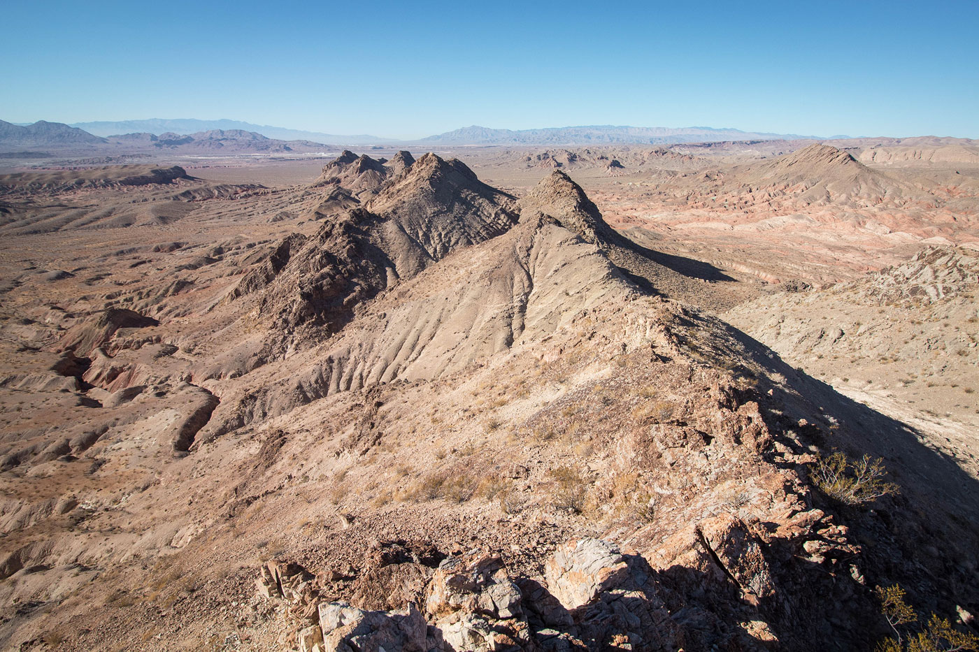
Seen from other angles, the Mud Peaks aren't all that cool-looking, but I was pretty impressed at how nice these peaks looked from here. he badlands we'd be traversing later visible to the north seemed a little tedious, but were quite pretty. We traced a potential route to the next peak on our list, Mud Tower. Getting there would require heading west through the desert and re-approaching from the south. So, we dropped down Mud Crag's loose Class 2 south slope and followed a series of drainages. I recommend not hugging the base of the peaks, since the drainages you'd be crossing over create lots of lumps. We headed farther out into the desert and were happy we did to avoid the humpy obstacles. Though it might have added a bit more distance than just hugging the peaks' base, we were able to keep the approach mostly flat. Choose your own adventure, I guess.
Once at the southeastern base of Mud Tower, we left the drainage system and found a path of least resistance (the drainages can get a little deep and hard to get out of) to its southern slope. The Class 2 approach on pretty loose rock led to a Class 3 miraculous break in the U-shaped summit cliff band, and we found ourselves on the summit. We could see Mud Hill to the north, and hoped to make a direct line to get there from Mud Tower, but the north face of Mud Tower's entire ridge was loose Class 4, so we instead backtracked and wrapped around a sub-peak to Mud Tower's east. This involved some side-hilling and easy Class 2 moves. We found ourselves in a drainage heading north into the red badlands separating Mud Tower from Mud Hill. I can't recommend a "best" option, since there are a multitude of drainges/ridges that lead all over the place. I think we did a pretty good job of navigating the labyrinth, but it's not easy to describe. Eventually we found ourselves ascending to the ridgeline of Mud Hill on a Class 2 slope. Looking back toward the badlands from here was interesting since we could mostly trace our route through the maze. The ridgeline leading to Mud Hill had a couple of optional, fun, solid Class 3 moves.
From the summit of Mud Hill, we backtracked along its east ridge and debated heading back into the badlands and route-finding to the main wash that we used earlier to approach the peaks. We both agreed it seemed a little tedious, since no wash/drainage seemed like an obvious option. Instead, we headed north to a dirt road that we followed east for a much easier jog through the desert. This added a bit more mileage, but made it very straightforward route. The road continued south into what formed the head of the primary wash we took to approach the peaks. We continued through the wash for a few miles back to the car.
Please consider helping me out if you find my site useful. I'm not sponsored, so all site fees are out-of-pocket and my time preparing these trip reports is unpaid. You can also hire me as a web developer. I really appreciate it!


If you find my site helpful, please help me replace my many broken cameras, fund my website fees (hosting, APIs, security), or just support my countless hours of work. I pay for all expenses myself, and all trip reports I post are unpaid and unsponsored, so any support is really appreciated!
If using PayPal, please select their option for "Sending to a friend" so they don't take out fees, thank you.
My site is free to use, but consider sending me a few bucks to help keep it running. Thanks in advance!