stav is lost logo
  • Find Hikes
    • Most recent
    • Trip Report Index
    • Hikes by Region
    • Search Hikes
  • Map
  • About
  • Love
Hike North Potosi Peak in Spring Mountains National Recreation Area, Nevada - Stav is Lost

Hike North Potosi Peak Spring Mountains National Recreation Area, NV

Class 2 6.1 miles 2800 gain 3-5 hrs Out and Back
Effort
Beauty
Personality
Solitude
DirectionsRoute MapDownload GPX

North Potosi Peak GPX Track

I will always provide a free route map, but you can also download a hike/drive GPX to assist you and to help support my site. Before sharing my GPX tracks with others, please remember my site is a free resource and I'm charging nominal fees to offset my substantial costs.

GPX track added to your cart.

Add to Cart ($2.50)
View Cart

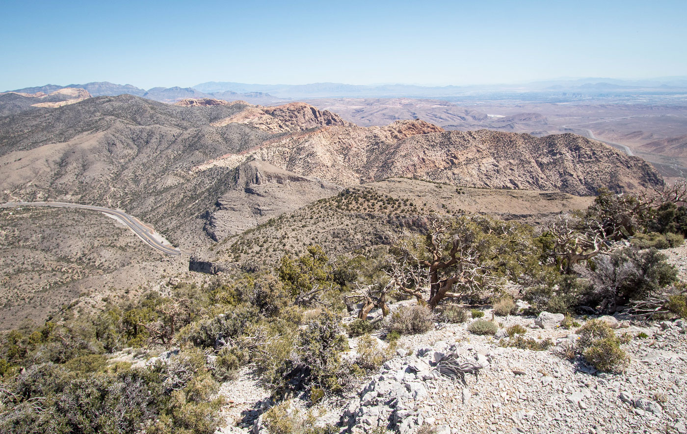
May 12, 2022 — North Potosi Peak (aka Buddha's Rest) is a small sub-peak of its larger southern neighbor, Potosi Mountain. With easy access just off NV-160, you'd think it might see more ascents than it does, but there's no clear "best" way to reach the summit. The issue is that the eastern face is brushy and has lots of cliff bands to navigate, while the western side is on Boy Scouts of America property. I teamed up with Yossi to get this little peak, and initially we wanted to approach using the BSA developed trail system. Signs prevented this, stating no parking on their land. So we instead improvised, parking within the National Forest boundary, just off the highway. The northern side has many limestone cliffs that climbers have bolted and use regularly. That being the case, a series of social trails has been developed that wrap up through the forest to the base of the many cliffs. Paula Raimondi located the best combination of these trails for accessing the BSA trail complex without parking on their land, and we decided to use her route.

A series of tight switchbacks lead up the first 400 feet or so before traversing beneath some cliffs and opening up to a wider view of the slopes. A difficult-to-find junction leads south and wraps up through a break in a tall cliff band on steep terrain. The trail is less obvious here, but with some poking around getting above the cliff should require no bushwhacking or scrambling harder than easy Class 2. The trail continued nicely as it slowly ascended to the west above the cliff band, and then merged with the BSA trail system on what seems to be called the "Fortress Trail". The trail makes one very long switchback and leads up another break in a cliff band to reach the northern ridge of North Potosi Peak. However, the good trail doesn't continue toward our summit from here, instead heading to a spot called Cottonwood Overlook, a nice little rest spot worth the quick jaunt.

After backtracking from Cottonwood Overlook, the trail hiking ended and we started south along the ridgeline. There's an initial potentially scary-looking limestone portion along the crest, but it goes at Class 2 and I recommend sticking to the crest to avoid rougher bushwhacking along the slope. Past the limestone portion, the ridge becomes less about scrambling and more just a steep dirt slope with embedded rocks. We made it up to a minor peak coined Meditation Point by Paula (keeping with the Buddha's Rest theme), and then continued along the ridgeline, requiring a short dip to Meditation Point's saddle with North Potosi. We passed by some sort of radio tower feature along the way, but otherwise nothing in terms of obstacles to note. It was a little brushy, but overall we just had to dodge low bushes and it wasn't unpleasant. The last half mile or so was more open and less steep, and the views from North Potosi Peak were nice in all directions.

PEAKS ON HIKE
Elevation (ft) / Prominence (ft)
Peaks on hike
Elevation
Prominence
1
Cottonwood Overlook
6924 ft
128 rise
2
Meditation Point
6824 ft
160 rise
3
North Potosi Peak (Buddha's Rest)
7418 ft
578 rise

Show me some love

Please consider helping me out if you find my site useful. I'm not sponsored, so all site fees are out-of-pocket and my time preparing these trip reports is unpaid. You can also hire me as a web developer. I really appreciate it!

Thank you

Next HikePrev Hike
  • Next Hike
  • More Near Here
  • Prev Hike
photo protector View toward the trailhead as we start up the tight switchbacks.
View toward the trailhead as we start up the tight switchbacks.
photo protector The trail is easy to follow and marked by cairns for the first 400 gain or so.
The trail is easy to follow and marked by cairns for the first 400 gain or so.
photo protector Ascending on climber trails to the base of the limestone cliffs.
Ascending on climber trails to the base of the limestone cliffs.
photo protector Nice trails, NV-160 visible below.
Nice trails, NV-160 visible below.
photo protector The trail follows the base of the cliffs for a bit. When it opens up like you see here, keep a lookout on the left for a social trail leading left to get over the cliff band.
The trail follows the base of the cliffs for a bit. When it opens up like you see here, keep a lookout on the left for a social trail leading left to get over the cliff band.
photo protector Yossi keeping left at a hard-to-miss junction.
Yossi keeping left at a hard-to-miss junction.
photo protector Ascending through the weakness in the cliff band, low Class 2, but uses a nice social trail.
Ascending through the weakness in the cliff band, low Class 2, but uses a nice social trail.
photo protector Above the cliff band, the trail traverses nicely, headed west.
Above the cliff band, the trail traverses nicely, headed west.
photo protector And then it merges with the well-maintained BSA trail system.
And then it merges with the well-maintained BSA trail system.
photo protector Along the nice trail.
Along the nice trail.
photo protector Fortress Trail leading up one very long switchback.
Fortress Trail leading up one very long switchback.
photo protector Continuing along the trail, NV-160 seen below.
Continuing along the trail, NV-160 seen below.
photo protector The trail leads through another break in the cliff to gain higher ground.
The trail leads through another break in the cliff to gain higher ground.
photo protector A short excursion to Cottonwood Overlook along the BSA trail.
A short excursion to Cottonwood Overlook along the BSA trail.
photo protector Cottonwood Overlook ahead.
Cottonwood Overlook ahead.
photo protector Cottonwood Overlook, view into Red Rock Canyon NCA.
Cottonwood Overlook, view into Red Rock Canyon NCA.
photo protector A view toward North Potosi Peak (left).
A view toward North Potosi Peak (left).
photo protector Onward to North Potosi Peak. Yossi seen below after leaving the BSA trail, now heading along the ridge crest.
Onward to North Potosi Peak. Yossi seen below after leaving the BSA trail, now heading along the ridge crest.
photo protector Class 2 along the limestone crest.
Class 2 along the limestone crest.
photo protector View back, Cottonwood Overlook visible top right.
View back, Cottonwood Overlook visible top right.
photo protector Class 2 and minimal bushwhacking on the way up to Meditation Point, seen top left.
Class 2 and minimal bushwhacking on the way up to Meditation Point, seen top left.
photo protector A bit steeper on the way up.
A bit steeper on the way up.
photo protector View back down the way we came.
View back down the way we came.
photo protector Meditation Point, view toward North Potosi Peak. Potosi Mountain seen distant center. We continued to the right along the ridge.
Meditation Point, view toward North Potosi Peak. Potosi Mountain seen distant center. We continued to the right along the ridge.
photo protector This is what the terrain is like much of the time. Dirt slope with some embedded rocks.
This is what the terrain is like much of the time. Dirt slope with some embedded rocks.
photo protector View back toward Meditation Point.
View back toward Meditation Point.
photo protector View along the ridge to North Potosi Peak (left).
View along the ridge to North Potosi Peak (left).
photo protector Pretty nice terrain for the last bit to the summit.
Pretty nice terrain for the last bit to the summit.
photo protector North Potosi visible left.
North Potosi visible left.
photo protector View back, Yossi doing a dance. Of course.
View back, Yossi doing a dance. Of course.
photo protector View toward North Potosi along the rim.
View toward North Potosi along the rim.
photo protector North Potosi Peak summit, view south toward Potosi Mountain.
North Potosi Peak summit, view south toward Potosi Mountain.
photo protector North Potosi Peak summit, view north toward Red Rock Canyon and Las Vegas.
North Potosi Peak summit, view north toward Red Rock Canyon and Las Vegas.

Show Me Some Love

If you find my site helpful, please help me replace my many broken cameras, fund my website fees (hosting, APIs, security), or just support my countless hours of work. I pay for all expenses myself, and all trip reports I post are unpaid and unsponsored, so any support is really appreciated!

If using PayPal, please select their option for "Sending to a friend" so they don't take out fees, thank you.

PayPalVenmoCash App

About  Contact  Love

© 2023 Stavros Basis.

DISCLAIMER: All activities you find on this site are dangerous. I am not responsible for anything you do in the outdoors. Please practice good ethics, and don't take any risks that put yourself or others in danger.


Thanks for visiting!

My site is free to use, but consider sending me a few bucks to help keep it running. Thanks in advance!

Sure!Nope.