

Lincoln Woods Trailhead.
A suspension bridge at the start of the Lincoln Woods Trail.
A viewpoint of the East Branch Pemigewasset River.
After a mile or so of flat walking, we reached the Osseo Trail junction.
Ascending the overall mostly tame Osseo Trail.
Higher up, some nice ladders.
View back the way we came after lots of forest hiking.
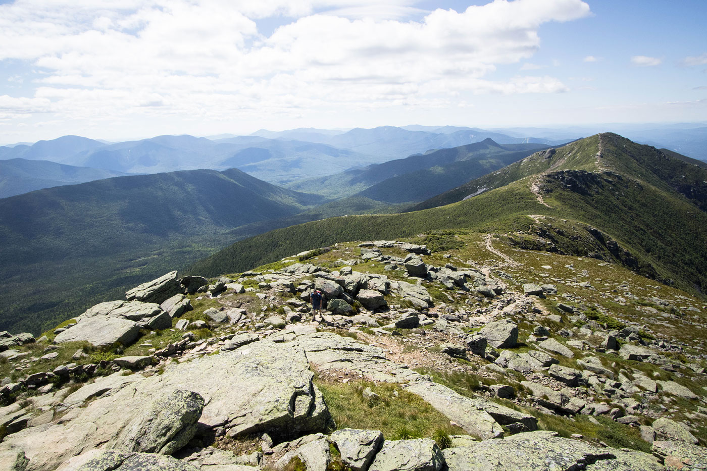
Some Class 2 before reaching Mount Flume.
Mount Flume ahead, Mount Liberty seen on the left.
Summit of Mount Flume, Mount Lafayette visible in the distance.
Descending from Mount Flume on our way to Mount Liberty, along the Franconia Ridge Trail.
Some Class 2.
Just below the summit of Mount Liberty, view back toward Mount Flume.
Mount Liberty summit, view toward Mount Lincoln. Lots of forest along the way. You can see the cliffs where Old Man of the Mountain used to be, and New Hampshire natives still lament deeply about the loss of their rock feature.
Descending from Mount Liberty with a decent view of the Pemi Loop still to come. In the distance you can see the Bonds, which are our last peaks of the Pemi Loop. In the center is Owls Head, another 4000er.
Close-up at the ridgeline to Mount Lincoln.
Forested descent from Mount Liberty.
Little Haystack Mountain seen ahead, blocking the view toward Mount Lincoln (really just a named feature at the top of the Falling Waters Trail rather than a mountain).
Ascending to Little Haystack Mountain.
Lots of rocky terrain.
View back toward Mount Flume and Mount Liberty from just below Little Haystack Mountain. A little ladder and some light Class 2 got us here.
Nearing the summit of Little Haystack Mountain.
Little Haystack Mountain summit, view back.
Onward to Mount Lincoln.
Close-up at the ridgeline to Mount Lincoln. This section started getting a bit more popular, rightfully so.
View back toward Little Haystack Mountain.
Last push to Mount Lincoln.
Some light Class 2 on the way to Mount Lincoln, though the trail is still easy to follow.
View back from Mount Lincoln toward Mount Flume and Mount Liberty.
Onward to Mount Lafayette along the gorgeous and most famous portion of Franconia Ridge.
Mount Lafayette ahead. You can also see Mount Garfield and South Twin on the right.
A cute little hump along the Franconia Ridge Trail.
Mount Lafayette ahead.
Last push to Mount Lafayette.
View back to Mount Lincoln along the Franconia Ridge Trail.
A wider shot, Owls Head seen on the left. the other half of the Pemi Loop is out of frame far left.
Mount Lafayette summit, view east. Mount Garfield, South Twin and the Bonds seen along the ridgeline still to come.
Descending from Mount Lafayette.
Down along the Garfield Ridge Trail, Mount Garfield seen ahead.
Back into the forest.
Some Class 2 scrambling on the way down.
Occasional view as we descent from Mount Lafayette.
Up and over Garfield Ridge, a small bump along the way.
Some gorgeous mosses.
Final bit of descending to the saddle on the west side of Mount Garfield.
Garfield Pond, a short hike away from the main trail.
Ascending to Mount Garfield.
Class 2 obstacles once in a while.
View back toward Mount Lafayette as we ascend to Mount Garfield.
Rocky trail and fairly steep.
Short spur trail to reach the summit of Mount Garfield.
Mount Garfield summit, view toward Mount Lafayette and the ridgeline we just hiked along.
Mount Garfield summit, view toward South Twin and the route to come. Galehead Mountain (which we didn't do) is seen center.
Descending from Garfield Mountain.
View back up along the trail.
Short break to filter water at the Garfield Ridge Campsite.
Still descending from Mount Garfield, a fun section where the views were open in a small boulder field with a hundred feet of Class 2/2+ descending.
View at the 100+ feet of Class 2/2+ descending on boulders.
Onward, lots of lush and beautiful forest.
View back toward Mount Garfield as we ascend toward South Twin.
A junction marking a quick spur trail to the Galehead Hut, located part of the way up the ascent to South Twin.
View toward South Twin from Galehead Hut.
Galehead Hut, Galehead Mountain on the left.
Onward to South Twin, a steep climb.
Some fun Class 2 on the way up South Twin, but mostly just a steep and bouldery hike.
View back toward Mount Lafayette (left) and Mount Garfield (center). You can also see the Galehead Hut above Adam's head.
Nearing the summit of South Twin, a wider shot of the first half of the Pemi Loop.
South Twin summit, view toward the remainder of the loop. Clearly much more tame in terms of vertical gain.
Onward to Mount Bond.
A bunch more forest walking along the ridge.
And then the ridgeline opens up again, yay! We took a short spur trail to get up to Mount Guyot on the left.
View back toward South Twin.
Mount Bond and West Bond ahead.
A bump along the ridgeline, view toward Mount Lafayette.
Ascent to Mount Bond.
Mount Bond summit, view northwest toward Mount Lafayette (left) and South Twin (right).
Mount Bond summit, view toward Bondcliff (left).
Descending Mount Bond, the gorgeous cliffs of Bondcliff seen ahead.
Excellent open ridgeline to Bondcliff.
Bondcliff summit, view toward Mount Bond. West Bond seen on the left (which we didn't do).
Descending from Bondcliff quickly led us back into the trees.
A Class 2+ move on the way down from Bondcliff.
And then it was many miles of forest walking, nothing particularly pretty or lush or memorable.
The remainder of the hike down the Bondcliff Trail was more or less this.
With a few little stream crossings.
And then we made it back to the old railroad bed, which we hike/ran for the miles back to the Lincoln Woods Trailhead.
Hire me or show me some love!
Hire/refer me as a web developer or send me a few bucks if you find my site useful. I’m not sponsored, so all fees are out-of-pocket and my time preparing trip reports is unpaid. I really appreciate it!