stav is lost logo
  • Find Hikes
    • Most recent
    • Trip Report Index
    • Hikes by Region
    • Search Hikes
  • Map
  • About
  • Love
Hike Mount Ascutney via Windsor and Brownsville Trails in Mount Ascutney State Park, Vermont - Stav is Lost

Hike Mount Ascutney via Windsor and Brownsville Trails Mount Ascutney State Park, VT

Class 1 9.2 miles 2800 gain 3-5 hrs Loop
Effort
Beauty
Personality
Solitude
DirectionsRoute MapDownload GPX

Mount Ascutney via Windsor and Brownsville Trails GPX Track

I will always provide a free route map, but you can also download a hike/drive GPX to assist you and to help support my site. Before sharing my GPX tracks with others, please remember my site is a free resource and I'm charging nominal fees to offset my substantial costs.

GPX track added to your cart.

Add to Cart ($2.50)
View Cart

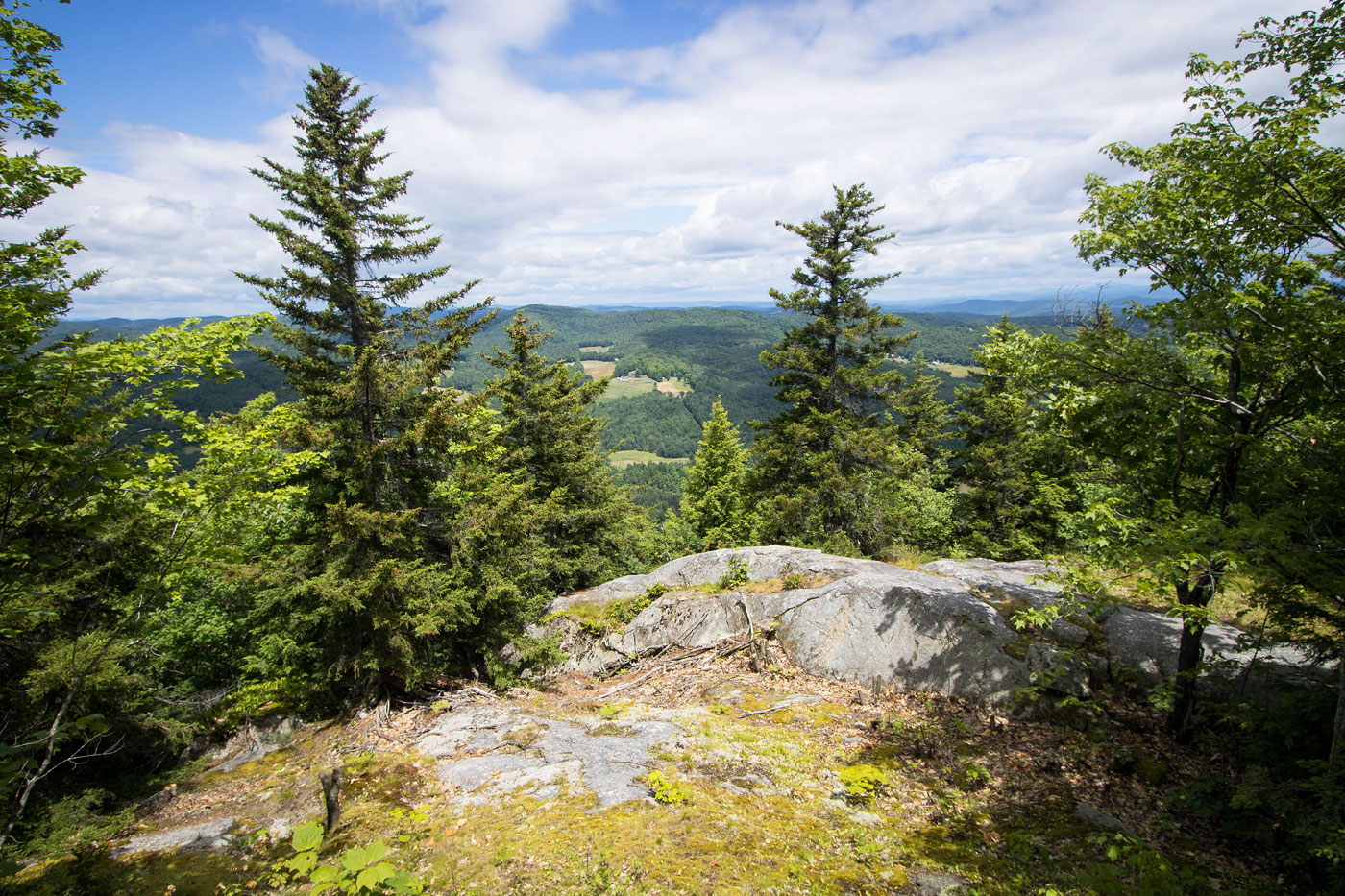
Jul 06, 2022 — Mount Ascutney is a high prominence peak located just off I-91 in Vermont. It lives on Mount Ascutney State Park, and there are three main trails used to reach the summit, the Weathersfield, Windsor, and Brownsville Trails. You can also drive up the park road to just below the summit. The Weathersfield Trail comes from the south, but I chose to approach from the north. Doing this allowed me to ascend via the Windsor Trail from and descend the Brownsville Trail to create a longer loop rather than only an out-and-back hike. The Brownsville Trail has its own trailhead, and you could instead descend to this trailhead and hike the road back to cut off some mileage, but I took a cutoff trail known as the Norcross Trail to stay in the woods a bit longer rather than hike on pavement. If you hike just the Windsor Trail as an out-and-back, the distance of this hike would be reduced by about 2 miles. All junctions are well-marked. 

I started from the Windsor Trailhead and hiked through a pretty meadow before entering the forest, which ascended along the right side of a drainage using an old roadbed. I passed by the small Gerry Falls and shortly after the roadbed narrowed into singletrack trail. I took a short spur trail to visit a nice lookout at Blood Rock and then continued on my way to the summit. Aside from the pretty forest and another small lookout point labeled Brownsville Rock, there wasn't much of note. Mount Ascutney's summit is covered in radio towers, and just before reaching it there is a small observation tower that gives better views.

I backtracked from the summit and started down along the Brownsville Trail, which included more forested trail hiking and was not dissimilar to the Windsor Trail. The Quarry Overlook lower down had some nice views, and I passed by some rusty old mining equipment. The Brownsville Trail followed an old roadbed for a time, and this would lead to the Brownsville Trailhead. However, I kept right at a junction when I reached the Norcross Trail, which would take me back to the Windsor Trail. The Norcross Trail is mostly used for mountain bikes and therefore had a bunch of unnecessary switchbacks, but I thought it was better than road walking.

PEAKS ON HIKE
Elevation (ft) / Prominence (ft)
Peaks on hike
Elevation
Prominence
1
Mount Ascutney
3130 ft
2270 rise

Show me some love

Please consider helping me out if you find my site useful. I'm not sponsored, so all site fees are out-of-pocket and my time preparing these trip reports is unpaid. You can also hire me as a web developer. I really appreciate it!

Thank you

Next HikePrev Hike
  • Next Hike
  • More Near Here
  • Prev Hike
photo protector Starting along the Windsor Trail.
Starting along the Windsor Trail.
photo protector A nice meadow just after starting.
A nice meadow just after starting.
photo protector A junction with the Norcross Trail shortly after entering the forest. I'll be returning from that trail later.
A junction with the Norcross Trail shortly after entering the forest. I'll be returning from that trail later.
photo protector Ascending the Windsor Trail via an roadbed turned trail.
Ascending the Windsor Trail via an roadbed turned trail.
photo protector No caption.
photo protector A sign for Gerry Falls.
A sign for Gerry Falls.
photo protector Gerry Falls.
Gerry Falls.
photo protector Along the Windsor Trail. I guess the rock can get slippery, so someone put some ropes.
Along the Windsor Trail. I guess the rock can get slippery, so someone put some ropes.
photo protector No caption.
photo protector Sign for a quick spur trail to visit Blood Rock.
Sign for a quick spur trail to visit Blood Rock.
photo protector Heading to Blood Rock.
Heading to Blood Rock.
photo protector Blood Rock overlook.
Blood Rock overlook.
photo protector Back on the Windsor Trail, ascending to Mount Ascutney.
Back on the Windsor Trail, ascending to Mount Ascutney.
photo protector Passing a shelter.
Passing a shelter.
photo protector Another well-signed junction.
Another well-signed junction.
photo protector No caption.
photo protector Junction with the Brownsville Trail. I'll be returning here on my way back.
Junction with the Brownsville Trail. I'll be returning here on my way back.
photo protector No caption.
photo protector Brownsville Rock overlook.
Brownsville Rock overlook.
photo protector A nice mossy hike along the ridgeline to reach the summit.
A nice mossy hike along the ridgeline to reach the summit.
photo protector A little observation tower just before reaching the summit of Mount Ascutney.
A little observation tower just before reaching the summit of Mount Ascutney.
photo protector View toward Mount Ascutney's summit from the observation tower.
View toward Mount Ascutney's summit from the observation tower.
photo protector On the observation tower.
On the observation tower.
photo protector Mount Ascutney summit.
Mount Ascutney summit.
photo protector Heading down along the Brownsville Trail to make a loop.
Heading down along the Brownsville Trail to make a loop.
photo protector Pretty ferns on the descent.
Pretty ferns on the descent.
photo protector A nice switchback feature along the Brownsville Trail.
A nice switchback feature along the Brownsville Trail.
photo protector North Peak vista, just another minor lookout along the way down.
North Peak vista, just another minor lookout along the way down.
photo protector No caption.
photo protector A somewhat rocky section along the Brownsville Trail.
A somewhat rocky section along the Brownsville Trail.
photo protector Quarry Overlook.
Quarry Overlook.
photo protector No caption.
photo protector View back at another lightly rocky section.
View back at another lightly rocky section.
photo protector Some old mining stuff.
Some old mining stuff.
photo protector Along the Brownsville Trail as it follows a roadbed for a bit.
Along the Brownsville Trail as it follows a roadbed for a bit.
photo protector Junction with the Norcross Trail. I kept right.
Junction with the Norcross Trail. I kept right.
photo protector Along the Norcross Trail, which contours east for a bit.
Along the Norcross Trail, which contours east for a bit.
photo protector A nice bridge along the Norcross Trail.
A nice bridge along the Norcross Trail.
photo protector Descending some switchbacks to get back down to the Windsor Trail.
Descending some switchbacks to get back down to the Windsor Trail.
photo protector No caption.

Show Me Some Love

If you find my site helpful, please help me replace my many broken cameras, fund my website fees (hosting, APIs, security), or just support my countless hours of work. I pay for all expenses myself, and all trip reports I post are unpaid and unsponsored, so any support is really appreciated!

If using PayPal, please select their option for "Sending to a friend" so they don't take out fees, thank you.

PayPalVenmoCash App

About  Contact  Love

© 2023 Stavros Basis.

DISCLAIMER: All activities you find on this site are dangerous. I am not responsible for anything you do in the outdoors. Please practice good ethics, and don't take any risks that put yourself or others in danger.


Thanks for visiting!

My site is free to use, but consider sending me a few bucks to help keep it running. Thanks in advance!

Sure!Nope.