I provide a free route map, but you can also download a hike/drive GPX to assist you and to help support my site. Before sharing my GPX tracks with others, please remember my site is a free resource and I'm charging nominal fees to offset my substantial costs.
GPX track added to your cart.
Mar 04, 2022 — Rumppah Point is located on the northern end of the Nopah Range, and is the slightly taller neighbor of the more popular Pahrump Point, but the ridgeline connecting the two seems to elude most hikers due to its steep and jagged terrain. I wouldn't be attempting the traverse today either, content to enjoy the thrill of the short knife-edge ridge. This peak seems to also be known as Pahrump Peak, but Rumppah Point was coined by Harlan Stockman, just the syllables reversed. I parked off the side of CA-178 at a poorly labeled wilderness boundary sign. People seem to ignore this sign and drive out into the desert to camp.
I started along the dirt roads on foot to the base of Rumppah Point's northwestern ridge. The slope began ascending at a gradual pace, introducing some light rockiness and nice views to the west. A hump along the ridge is avoidable via some easy side-hilling on its east slope. A short section of relatively flat walking led to the base of the steeper ascent to the summit, but nothing exceeded light Class 2 along this ascent slope.
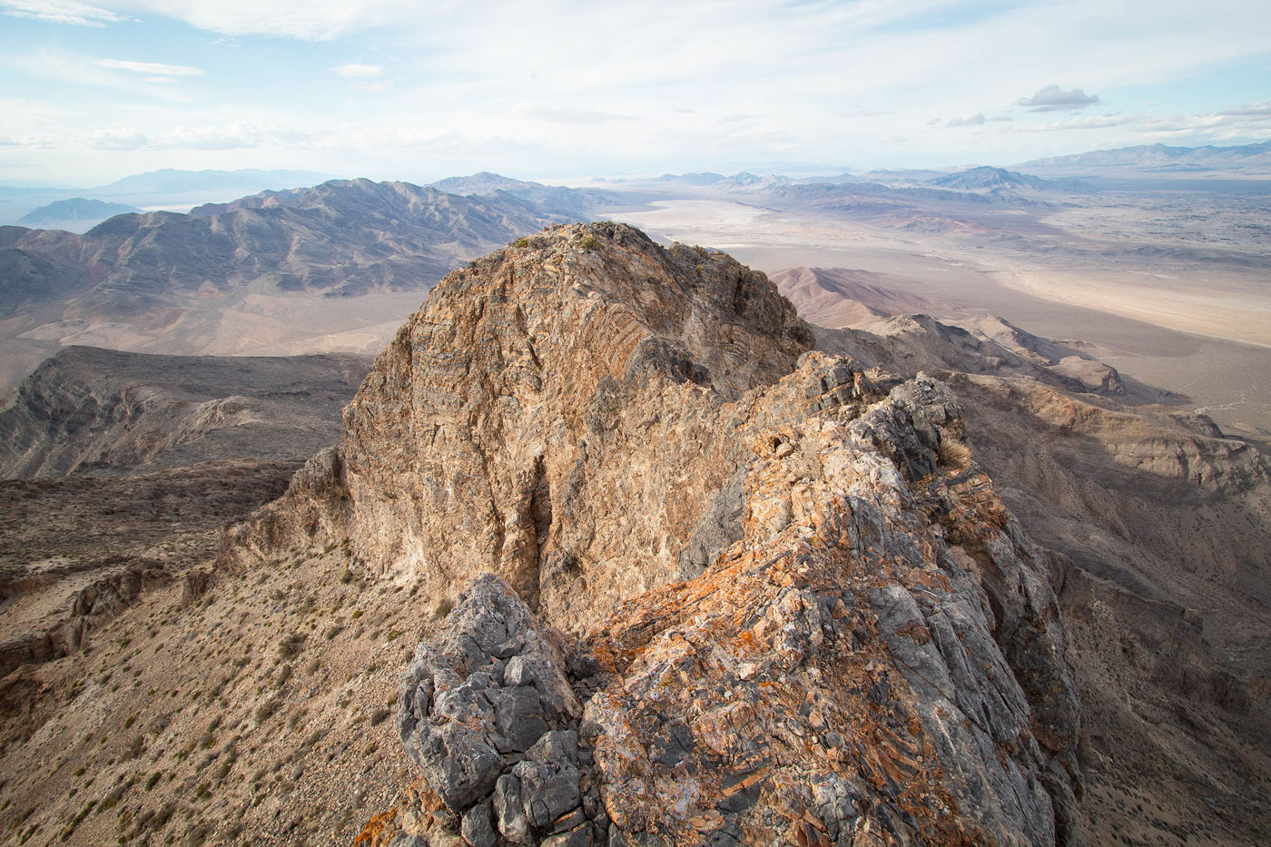
Now at the base of the final few hundred vertical feet, I prepared myself for what was reported to be an exposed knife edge ridge to gain the summit. I noted a more tame-looking slope on the right that could potentially bypass the knife-edge (more on that shortly), but I decided to first continue along the ridge crest, which introduced a short scree chute and then some light Class 3. Now confronted with the knife-edge, I secured my loose-hanging jacket and braced myself against the wind, starting across the initial few steps. The crux was comprised of a short Class 3 down-climb just left of the knife-edge crest with a severe drop on the left, followed by an easier few moves to regain the crest. Past here, there was a not particularly safe series of moves along the crest, but the rock was overall solid and aside from the exposure playing mind games with me I didn't find it to be too difficult. Once the knife-edge was over, a few short Class 2/2+ moves led to the summit block of Rumppah Point.
After taking in the sunset views, I decided I wanted to try to find a less exposed route down, so after backtracking off the summit block and reaching the start of the knife-edge, I scrambled down a much more reasonable Class 3 set of moves on the south side of the ridge crest. I marked this in purple on my attached map. It was still a bit exposed, but there were more holds and it was a lot less scary. Now on the south side of the knife-edge on safe terrain, some scree along the base led to the spot I had noted earlier, bypassing the knife-edge completely. I returned the way I came along the northwest ridge.
Please consider helping me out if you find my site useful. I'm not sponsored, so all site fees are out-of-pocket and my time preparing these trip reports is unpaid. You can also hire me as a web developer. I really appreciate it!


If you find my site helpful, please help me replace my many broken cameras, fund my website fees (hosting, APIs, security), or just support my countless hours of work. I pay for all expenses myself, and all trip reports I post are unpaid and unsponsored, so any support is really appreciated!
If using PayPal, please select their option for "Sending to a friend" so they don't take out fees, thank you.
My site is free to use, but consider sending me a few bucks to help keep it running. Thanks in advance!