stav is lost logo
  • Find Hikes
    • Most recent
    • Trip Report Index
    • Hikes by Region
    • Search Hikes
  • Map
  • About
  • Love
Hike Sawtooth Peak, Spanish Needle, Lamont Peak Traverse in Owens Peak Wilderness Area, California - Stav is Lost

Hike Sawtooth Peak, Spanish Needle, Lamont Peak Traverse Owens Peak Wilderness Area, CA

Class 3 17.5 miles 7300 gain 11-15 hrs One Way
Effort
Beauty
Personality
Solitude
DirectionsRoute MapDownload GPX

Sawtooth Peak, Spanish Needle, Lamont Peak Traverse GPX Track

I will always provide a free route map, but you can also download a hike/drive GPX to assist you and to help support my site. Before sharing my GPX tracks with others, please remember my site is a free resource and I'm charging nominal fees to offset my substantial costs.

GPX track added to your cart.

Add to Cart ($3.50)
View Cart

May 23, 2020 — What a great traverse to wrap up the peaks I was most excited for in the southern Sierra area. This traverse hits Sawtooth Peak, Lamont Benchmark, Spanish Needle, East Lamont, Lamont, and West Lamont Peaks. I met up with a new friend Tyler, this after spending some time planning a trip/route and untimately settling on this one. He's a very capable hiker and climber, and I was thrilled to find we could spend the whole day talking while still making quick time, and it made the route that much better. Hoping for more soon, new friend!

In order to do this route, we needed to set up a shuttle to avoid 4+ miles of road walking. You can definitely make it a loop if you're okay with the additional road miles. We parked the end car here (35.78777, -118.07201), and drove to the Pacific Crest Trail trailhead at the coordinates marked for this trip report. We set out along the pleasant PCT, making quick work of the first few miles to the saddle south of Sawtooth Peak. A steep slope led to the summit, a social trail helping us out most of the way. Toward the top, the brush became a bit thicker and we needed a minute to be sure we were still going a viable route. The summit block requires Class 2, but otherwise there's no scrambling for this ascent, just steepness.

Back at the PCT, we followed it south to the eastern saddle of Lamont Benchmark. This smaller peak required a sandy ascent, but had great views from its Class 3 summit block. Being a central point of our planned route, we could see our entire plan for the day. We were excited to keep moving.

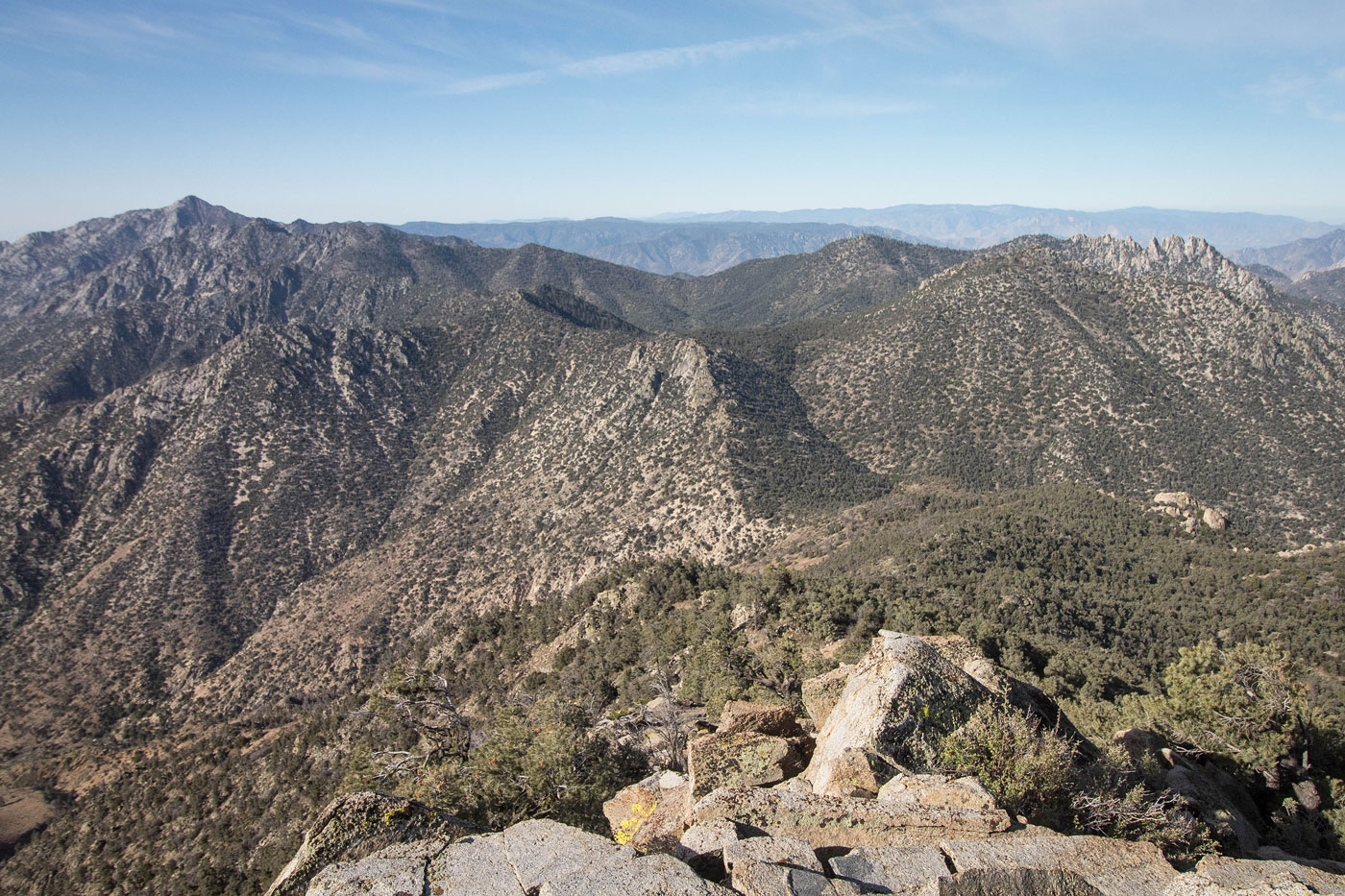
We followed the PCT for a while longer and made it to a viewpoint of Spanish Needle, our next peak on the list. We didn't expect the route to its high point to be quite so tedious, and fair warning that the only thing to look forward to on this one is the summit ridge. A social trail took us off the PCT and headed south, where we side-hilled the east slopes of Spanish Needle. Dropping too low and you'll have to re-ascend, and going too high would result in getting cliffed out. We did a pretty good job on the ascent, but failed miserably coming back. I've included what I thought was the best route on my attached map. The route involves crossing over multiple talus fields, scrambling up loose and dirty gullies, and dealing with sappy pine needles and downed trees. Not super fun. After about 40 minutes, we made it to the ridge, which became more pleasant. We encountered a couple of Class 2/3 moves and were finally at a false summit viewpoint of the technical section of the route leading to the true summit. We actually saw another group on their way back down, surprisingly.

The route involves descending about a hundred feet to Spanish Needle's northern saddle. This section involved short Class 3 sections with no exposure. Once at the saddle, we located a Class 3+ scramble to get up to a unique slab. The slab wasn't steep enough to be dangerous. Another Class 3 move past a tree brought us up to the final push. The route we took starts at a notch on the right and climbs a somewhat exposed Class 3 section using a set of granite flakes. The summit views were quite nice.

Back at the PCT, we headed to the eastern saddle of East Lamont Peak, leaving the PCT on a social trail. We were immediately happy to see the trail since our research said this would be a bit of a bushwhack, but we were duped. The social trail headed along the northern slopes, which was not the way we wanted to go. Ignore the social trail and stay on the ridge as you ascend to East Lamont (I corrected this on my map). There is definitely a bit of brush, but it's not terrible. Along the ridge to East Lamont Peak, we had to maneuver two sets of rock outcroppings. The first was located a few hundred feet from the summit and had a 30 foot Class 2 downclimb bypass on the right, and the second involved a 50 foot Class 2+ brushy scramble to the summit (it's possible there's a more reasonable way up this second obstacle).

From East Lamont Peak, the traverse over to Lamont Peak was straightforward, except we probably stayed too high. I wasn't upset about it because we got nice views to the south, but you may want to keep just north of the ridge to avoid extra work. Soon we were at the base of Lamont Peak, an intimidating-looking set of massive boulders and brush. We hugged the cliff face and followed it to the summit with minimal unpleasantness and only a Class 2 section toward the top, the peak being far easier than anticipated.

From here we followed the eroded and well-cairned Lamont Peak Trail down along the peak's west ridge. It dropped us to the saddle with West Lamont Peak. This would be our last peak of the day. We stayed on the Lamont Peak Trail until we were just south of the West Lamont Peak summit, then left the trail in an attempt to find a route up. Some Class 2 and a little navigation led us around some boulders and to the midpoint of two potential high point blocks, separated from each other by a couple hundred feet of some Class 2/3 playful boulder-hopping. We weren't sure which was higher, so we got both. The western block was a Class 3+ slab that gave me pause, and the eastern block was Class 3 juggy fun. After the final summit, we got back on the Lamont Peak Trail and followed it down to the second car. The Lamont Peak Trail is underused and has a bit of overgrowth, but it doesn't warrant calling it condemned just yet. There were cairns in many spots that were hard to follow, and the views were really incredible. I recommend doing the route in the direction we did, since ascending the PCT is preferable to ascending the Lamont Peak Trail, which is much more steep.

PEAKS ON HIKE
Elevation (ft) / Prominence (ft)
Peaks on hike
Elevation
Prominence
1
Sawtooth Peak
8000+ ft
1720 rise
2
Lamont Benchmark
7621 ft
781 rise
3
Spanish Needle
7841 ft
881 rise
4
East Lamont Peak
7475 ft
795 rise
5
Lamont Peak
7429 ft
229 rise
6
West Lamont Peak
7320+ ft
280 rise

Show me some love

Please consider helping me out if you find my site useful. I'm not sponsored, so all site fees are out-of-pocket and my time preparing these trip reports is unpaid. You can also hire me as a web developer. I really appreciate it!

Thank you

Next HikePrev Hike
  • Next Hike
  • More Near Here
  • Prev Hike
photo protector Starting out along the Pacific Crest Trail.
Starting out along the Pacific Crest Trail.
photo protector Lamont Benchmark visible in the center, Lamont Peak on the right.
Lamont Benchmark visible in the center, Lamont Peak on the right.
photo protector Working our way up to the saddle south of Sawtooth Peak.
Working our way up to the saddle south of Sawtooth Peak.
photo protector Starting up to Sawtooth Peak along a social trail. Sawtooth is visible right of center.
Starting up to Sawtooth Peak along a social trail. Sawtooth is visible right of center.
photo protector Looking back at the traverse to come as we make our way up to Sawtooth Peak. Spanish Needle visible top center.
Looking back at the traverse to come as we make our way up to Sawtooth Peak. Spanish Needle visible top center.
photo protector Steep, sandy slope up to Sawtooth Peak.
Steep, sandy slope up to Sawtooth Peak.
photo protector No caption.
photo protector Another shot back down the way we came, Owens Peak visible center.
Another shot back down the way we came, Owens Peak visible center.
photo protector Final push through some brush to Sawtooth Peak.
Final push through some brush to Sawtooth Peak.
photo protector Looking back from the summit of Sawtooth Peak. On the right is Lamond Benchmark, behind it is Lamont Peak, Owens Peak top left, Spanish Needle in front of Owens.
Looking back from the summit of Sawtooth Peak. On the right is Lamond Benchmark, behind it is Lamont Peak, Owens Peak top left, Spanish Needle in front of Owens.
photo protector Sawtooth Peak summit.
Sawtooth Peak summit.
photo protector Heading back from Sawtooth Peak to the Pacific Crest Trail.
Heading back from Sawtooth Peak to the Pacific Crest Trail.
photo protector Back on the Pacific Crest Trail, heading south.
Back on the Pacific Crest Trail, heading south.
photo protector One major switchback along the PCT, a view back toward Sawtooth Peak and the ascent right we took to get to its summit earlier.
One major switchback along the PCT, a view back toward Sawtooth Peak and the ascent right we took to get to its summit earlier.
photo protector No caption.
photo protector Approaching the spot where we left the Pacific Crest Trail to get to Lamont Benchmark, seen ahead.
Approaching the spot where we left the Pacific Crest Trail to get to Lamont Benchmark, seen ahead.
photo protector Steep sand on the way up to Lamont Benchmark.
Steep sand on the way up to Lamont Benchmark.
photo protector Looking back as we ascend, Sawtooth Peak visible top left.
Looking back as we ascend, Sawtooth Peak visible top left.
photo protector The route continues through a forested section just below the summit.
The route continues through a forested section just below the summit.
photo protector Lamont Benchmark summit block, Class 3.
Lamont Benchmark summit block, Class 3.
photo protector Lamont Benchmark, view north toward Spanish Needle and Owens Peak top right.
Lamont Benchmark, view north toward Spanish Needle and Owens Peak top right.
photo protector Back on the Pacific Crest Trail, which heads to the right of these humps ahead.
Back on the Pacific Crest Trail, which heads to the right of these humps ahead.
photo protector Pacific Crest Trail, Spanish Needle ahead.
Pacific Crest Trail, Spanish Needle ahead.
photo protector Nearing the saddle (center) where we left the Pacific Crest Trail, heading left to Spanish Needle.
Nearing the saddle (center) where we left the Pacific Crest Trail, heading left to Spanish Needle.
photo protector After leaving the saddle, heading along a social trail that wasn't super helpful along the northern slopes of Spanish Needle. There are a few rock ribs like the one seen in the center of this photo that require some thought to keep the route Class 2/3.
After leaving the saddle, heading along a social trail that wasn't super helpful along the northern slopes of Spanish Needle. There are a few rock ribs like the one seen in the center of this photo that require some thought to keep the route Class 2/3.
photo protector Class 2 boulder-hopping. We headed to the tree in the center. It's a tricky section where going too high or low could result in awful terrain.
Class 2 boulder-hopping. We headed to the tree in the center. It's a tricky section where going too high or low could result in awful terrain.
photo protector A key section to stay on route.
A key section to stay on route.
photo protector Class 2 talus ends and we side-hilled on forested terrain.
Class 2 talus ends and we side-hilled on forested terrain.
photo protector Looking back at our progress, the saddle we left the PCT from visible center.
Looking back at our progress, the saddle we left the PCT from visible center.
photo protector Some Class 2 when we determined it was a good time to stop side-hilling and start ascending.
Some Class 2 when we determined it was a good time to stop side-hilling and start ascending.
photo protector Class 2 just below the false summit.
Class 2 just below the false summit.
photo protector Looking back as we near the false summit along the ridge. As you can see here on the top left, ascending too early would result in awful terrain.
Looking back as we near the false summit along the ridge. As you can see here on the top left, ascending too early would result in awful terrain.
photo protector Class 2/3 ridgeline to the false summit of Spanish Needle.
Class 2/3 ridgeline to the false summit of Spanish Needle.
photo protector Spanish Needle false summit, view toward the true summit. There were some other hikers coming back from the summit.
Spanish Needle false summit, view toward the true summit. There were some other hikers coming back from the summit.
photo protector Some Class 3 along the ridge.
Some Class 3 along the ridge.
photo protector Tyler scoping out the slab. A Class 3+ move by the small tree left of center leads to the slab.
Tyler scoping out the slab. A Class 3+ move by the small tree left of center leads to the slab.
photo protector We kept high on the slab.
We kept high on the slab.
photo protector Looking back along the slab toward the false summit we came from.
Looking back along the slab toward the false summit we came from.
photo protector Tyler scrambling some more Class 3 just below the summit. We wrapped around the right side here on granite flakes, slightly exposed.
Tyler scrambling some more Class 3 just below the summit. We wrapped around the right side here on granite flakes, slightly exposed.
photo protector Spanish Needle summit, view toward Owens Peak.
Spanish Needle summit, view toward Owens Peak.
photo protector Spanish Needle summit, view toward the Lamont ridgeline we'd be doing next (left) and Lamont Benchmark (right).
Spanish Needle summit, view toward the Lamont ridgeline we'd be doing next (left) and Lamont Benchmark (right).
photo protector Back on the Pacific Crest Trail.
Back on the Pacific Crest Trail.
photo protector East Lamont Peak top right.
East Lamont Peak top right.
photo protector We left the Pacific Crest Trail at East Lamont Peak's eastern saddle. It will be tempting to follow a social trail, but it leads to the right and away from the peak. Stick to the ridge, even though it's a bit more bushwhacky than we liked.
We left the Pacific Crest Trail at East Lamont Peak's eastern saddle. It will be tempting to follow a social trail, but it leads to the right and away from the peak. Stick to the ridge, even though it's a bit more bushwhacky than we liked.
photo protector Continuing along the ridge, some bushwhacking and some nice walking like this.
Continuing along the ridge, some bushwhacking and some nice walking like this.
photo protector Nearing the summit of East Lamont Peak, Spanish Needle visible top left and Owens Peak visible top right.
Nearing the summit of East Lamont Peak, Spanish Needle visible top left and Owens Peak visible top right.
photo protector East Lamont Peak false summit ahead.
East Lamont Peak false summit ahead.
photo protector Looking back again.
Looking back again.
photo protector Getting to East Lamont Peak required a short down climb on the right to avoid cliffs, then to re-ascend to get to higher ground.
Getting to East Lamont Peak required a short down climb on the right to avoid cliffs, then to re-ascend to get to higher ground.
photo protector East Lamont Peak summit block, view back toward Spanish Needle (top center).
East Lamont Peak summit block, view back toward Spanish Needle (top center).
photo protector East Lamont Peak, view west toward Lamont Peak and its scary-looking north ridge that we wouldn't be dealing with. It just looks pretty.
East Lamont Peak, view west toward Lamont Peak and its scary-looking north ridge that we wouldn't be dealing with. It just looks pretty.
photo protector Through the forest as we traverse to Lamont Peak.
Through the forest as we traverse to Lamont Peak.
photo protector Staying on the ridge made the going a bit more tedious, but we did get some nice views. Keep to the right of the ridge for easier terrain.
Staying on the ridge made the going a bit more tedious, but we did get some nice views. Keep to the right of the ridge for easier terrain.
photo protector Lamont Peak visible on the left. None of those pinnacles on the right are part of the route fortunately.
Lamont Peak visible on the left. None of those pinnacles on the right are part of the route fortunately.
photo protector Lamont Peak above. It looked intimidating, but a nice social trail led along the cliffs' base and safely up some Class 2 terrain to the stummit.
Lamont Peak above. It looked intimidating, but a nice social trail led along the cliffs' base and safely up some Class 2 terrain to the stummit.
photo protector Lamont Peak, view back along the ridge to Spanish Needle (center top) and Owens Peak (top right).
Lamont Peak, view back along the ridge to Spanish Needle (center top) and Owens Peak (top right).
photo protector East Lamont Peak, view toward West Lamont Peak.
East Lamont Peak, view toward West Lamont Peak.
photo protector We followed the obvious and sandy Lamont Peak Trail down.
We followed the obvious and sandy Lamont Peak Trail down.
photo protector Looking back toward Lamont Peak as we continue on the Lamont Peak Trail.
Looking back toward Lamont Peak as we continue on the Lamont Peak Trail.
photo protector The trail was in surprisingly good shape. At this meadowy section, we left the trail and headed to the right to locate a route up to West Lamont Peak.
The trail was in surprisingly good shape. At this meadowy section, we left the trail and headed to the right to locate a route up to West Lamont Peak.
photo protector After leaving the Lamont Peak Trail, we headed through some brush and on bouldery terrain. The summit area isn't clear yet.
After leaving the Lamont Peak Trail, we headed through some brush and on bouldery terrain. The summit area isn't clear yet.
photo protector Just below some gnarly cliffs, and after pulling a couple of difficult-to-describe Class 2/3 moves we were at the base of the potential high points of West Lamont Peak (above out of frame on the left.
Just below some gnarly cliffs, and after pulling a couple of difficult-to-describe Class 2/3 moves we were at the base of the potential high points of West Lamont Peak (above out of frame on the left.
photo protector Some more minor route finding led us to the summit area. Possible West Lamont Peak high point is visible ahead  to the right of Tyler.
Some more minor route finding led us to the summit area. Possible West Lamont Peak high point is visible ahead to the right of Tyler.
photo protector Tyler on the Class 3+ slab move for our first high point (the western one marked on my map).
Tyler on the Class 3+ slab move for our first high point (the western one marked on my map).
photo protector Tyler on the crux of the western possible high point.
Tyler on the crux of the western possible high point.
photo protector Summit of the western potential high point, view east toward the summit block area (below) and the possible eastern high point (right of the tree in the center). Lamont Peak is visible top right.
Summit of the western potential high point, view east toward the summit block area (below) and the possible eastern high point (right of the tree in the center). Lamont Peak is visible top right.
photo protector After boulder-hopping to the east for a few hundred feet, we made it to this juggy, fun Class 3 possibly higher high point (the eastern dot on my map) on West Lamont Peak.
After boulder-hopping to the east for a few hundred feet, we made it to this juggy, fun Class 3 possibly higher high point (the eastern dot on my map) on West Lamont Peak.
photo protector West Lamont Peak's eastern high point, view toward Spanish Needle and Owens Peak.
West Lamont Peak's eastern high point, view toward Spanish Needle and Owens Peak.
photo protector Back on the Lamont Peak Trail, we continued with only a couple of minor issues with route-finding.
Back on the Lamont Peak Trail, we continued with only a couple of minor issues with route-finding.
photo protector Overall the trail was great. Chimney Peak Road visible center. Our end car was down there somwhere.
Overall the trail was great. Chimney Peak Road visible center. Our end car was down there somwhere.
photo protector One section along the Lamont Peak Trail where the trail pops over a Class 2 boulder that was hard to follow. We added a cairn, but it might be gone, so just pay attention. The trail was always good enough to follow, so don't start bushwhacking.
One section along the Lamont Peak Trail where the trail pops over a Class 2 boulder that was hard to follow. We added a cairn, but it might be gone, so just pay attention. The trail was always good enough to follow, so don't start bushwhacking.

Show Me Some Love

If you find my site helpful, please help me replace my many broken cameras, fund my website fees (hosting, APIs, security), or just support my countless hours of work. I pay for all expenses myself, and all trip reports I post are unpaid and unsponsored, so any support is really appreciated!

If using PayPal, please select their option for "Sending to a friend" so they don't take out fees, thank you.

PayPalVenmoCash App

About  Contact  Love

© 2023 Stavros Basis.

DISCLAIMER: All activities you find on this site are dangerous. I am not responsible for anything you do in the outdoors. Please practice good ethics, and don't take any risks that put yourself or others in danger.


Thanks for visiting!

My site is free to use, but consider sending me a few bucks to help keep it running. Thanks in advance!

Sure!Nope.