

Starting along the Baker Creek Trail.
After a few miles along the trail, we headed left across Baker Creek and up the talus slope visible on the left.
Crossing Baker Creek, heading to the gully visible center. The gully led straight up to False Pyramid.
Class 2 gully.
Looking back, Doso Doyabi (Jeff Davis Peak) visible up top.
Sam navigating the scree/talus.
Class 2 below the summit of False Pyramid.
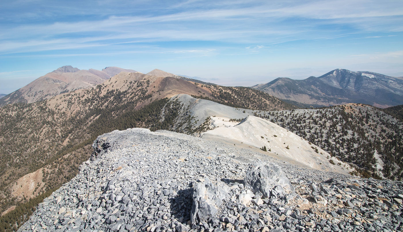
Just below the summit of False Pyramid, view back down toward Baker Creek. Doso Doyabi visible top left.
False Pyramid summit, view toward Baker Peak (top right) and Baker Lake (center).
Heading to Pyramid Peak.
Just below Pyramid Peak summit, view back toward False Pyramid (right) and Wheeler/Doso Doyabi (left).
Continuing down to the Baker-Johnson Saddle.
Johnson Lake on the left. Johnson Peak visible top center.
Looking back, Pyramid Peak top right and the trail down to Baker Lake visible left.
Continuing up to Johnson Peak on Class 2.
Looking back from near the top of Quartzite Peak toward Pyramid Peak (top right), Johnson Lake (bottom right), and Wheeler Peak (top left).
Quartzite Peak summit, view toward Johnson Peak.
Johnson Peak, view back at our progress.
Mount Washington ahead on the right. Lincoln Peak visible center. Granite Peak left of center. Peak 11040 far left.
Along the ridge to Mount Washington.
Incredibly cool colors.
Interesting eroded cliffs of Mount Washington. The route goes up the ridge on the left.
Looking back at the crazy-colored ridgeline.
Push to Mount Washington summit.
Mount Washington, view toward our traverse so far. Wheeler Peak visible top left.
Heading south from Mount Washington, first on a dirt road and then leaving it to just follow the rim.
Looking back toward Mount Washington.
Continuing down along the rim. Lincoln Peak is visible top right. Peak 11040 visible far left.
We rejoined a forest road that brought us to the Washington-Lincoln saddle.
And then we continued though the forest for a while, avoiding a couple of minor bumps along the ridge.
Just past treeline, we encountered some Class 2 talus. This is a view looking back the way we came, Mount Washington visible top left.
Just past the Class 2 talus, a pretty tundra section leads to Lincoln Peak, visible on the left.
Just a nice view to the east, lots of really interesting canyons. That's Peak 11040 on the right.
Push to Lincoln Peak.
Lincoln Peak ahead.
Along the ridge to Lincoln Peak (Class 2/3). View looking back at our route so far.
The Class 2+ (maybe 3) move. Avoidable by wrapping around Lincoln Peak.
Final push along the ridgeline to the summit of Lincoln Peak.
Lincoln Peak summit, view back the way we came.
We headed off Lincoln Peak onto a sweeping tundra.
We followed the rim.
Gorgeous!
Looking back along the tundra, Lincoln Peak now out of view. Wheeler Peak visible top right.
Peak 11040 (left) and Granite Peak (right) came into view.
Wide show of Sam heading down the quick-moving sloping ridgeline.
Peak 11040 ahead, but the rim was interesting and jagged and I needed a photo of it.
Peak 11040 ahead.
Peak 11040 on the left. First we'd have to go over this major bump, followed by another minor one.
Looking back from the top of the first major bump, Lincoln Peak up there somewhere.
Peak 11040 ahead, seen as we come down from the major bump.
Some super-light Class 2 on some short sections on our way up to Peak 11040.
Just below the Peak 11040 summit, view back. Lincoln Peak visible top right, the major hump we had to go over visible on the left.
Final push to Peak 11040.
Peak 11040 summit, interesting perspective toward the primary Snake Range ridgeline.
Peak 11040 summit, view east into Utah.
Back on the primary ridgeline, heading to Granite Peak. You can see the three humps of Granite Peak - the true summit is just left of center. The two bumps on the far left are nothing, but our route would lead to the saddle of those two bumps before we would descend from the ridgeline.
Looking back toward Peak 11040 (right).
Granite Peak ahead on the right, the two minor bumps also visible on the left.
Sam about to start up the steep ridge to the summit.
Looking back along the ridgeline to Granite Peak. Peak 11040 visible off the primary ridgeline on the right. Lincoln Peak sort of visible top left. Wheeler Peak visible top center.
Granite Peak is located just off the ridgeline, ahead.
Granite Peak summit, somewhat obscured by trees.
We dropped off Granite Peak, heading to the saddle in the center of this photo. We would ascend the bump just right of center, then drop to the saddle between the bumps, and then descend from the ridgeline from there.
After ascending the first minor bump, dropping down on an animal trail to the saddle between the two bumps.
Dropping down on steep, pleasant terrain.
Lots of dropping, some ankle-high brush, but it was a great descent. Our goal is to go to the ridgeline in the center of this photo, just right of the brush-capped minor peak.
Almost at the bottom of the descent from Granite Peak. Our goal is the ridge just to the right of the brush-capped peak in the center of this photo. First, we'd have to bushwhack through some nonsense.
Starting into the forest.
Sam bushwhacking.
View back the way we came. The descent route we took is the drainage on the top left. This was past the worst of the bushwhacking.
Brush-covered peak marking the ridgeline we needed to get to.
After getting over the ridge, we dropped down into Lexington Arch Canyon.
Lexington Arch ahead!
Lexington Arch.
Along the official Lexington Arch Trail, looking back toward Lexington Arch.
Along the official trail, which switchbacks a bunch down the slope. Our end car is somewhere in the valley left of center.
Looking back the way we came toward Lexington Arch Canyon (right). The trail ended shortly after this and became an old road that we followed back to the car.
Hire me or show me some love!
Hire/refer me as a web developer or send me a few bucks if you find my site useful. I’m not sponsored, so all fees are out-of-pocket and my time preparing trip reports is unpaid. I really appreciate it!