stav is lost logo
  • Find Hikes
    • Most recent
    • Trip Report Index
    • Hikes by Region
    • Search Hikes
  • Map
  • About
  • Love
Hike Treasury Mountain and Treasure Mountain in White River National Forest, Colorado - Stav is Lost

Hike Treasury Mountain and Treasure Mountain White River National Forest, CO

Class 2 12.2 miles 5100 gain 6-8 hrs Out and Back
Effort
Beauty
Personality
Solitude
DirectionsRoute MapDownload GPX

Treasury Mountain and Treasure Mountain GPX Track

I will always provide a free route map, but you can also download a hike/drive GPX to assist you and to help support my site. Before sharing my GPX tracks with others, please remember my site is a free resource and I'm charging nominal fees to offset my substantial costs.

GPX track added to your cart.

Add to Cart ($2.50)
View Cart

Sep 16, 2021 — Treasury Mountain and Treasure Mountain are a couple of 13ers outside of Crested Butte, two of only a small handful in the area. I wanted to get them both in a day, despite the route not making a ton of sense since linking them up along the ridge isn't possible due to a Class 5 cliff (or so I've heard). I reached the Yule Pass Trailhead (any vehicle can get there) and set out along the Yule Pass Trail, an old road that has been eroded into a narrow and sometimes treacherous trail. A couple of spots were particularly steep on the left and required a little bit of extra care, uncommon for Colorado trails.

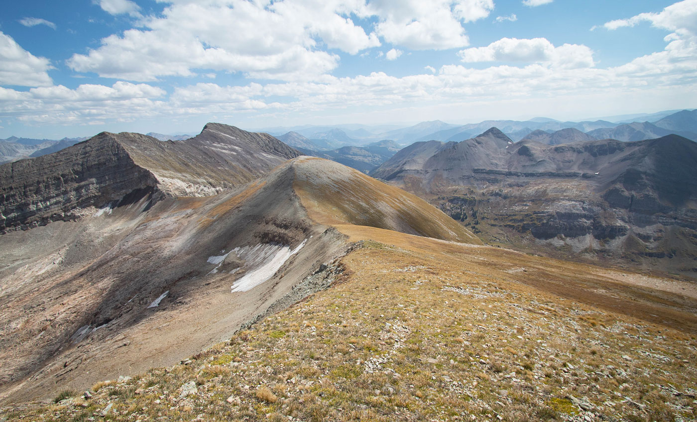
After a mile along the Yule Pass Trail, I decided to head up an obvious social trail on the right in order to access Treasury Mountain first. The ridgeline was for its majority a nice Class 1 hike with some steep sections. About halfway up I crossed a significant flat section from where I'd descend later. Past the flat bit, a somewhat faded social trail leads up a not-unpleasant talus/scree slope, followed by a lovely flat section where Treasury Mountain came into view. The last bit to the summit introduced some Class 2. A social trail wrapped around to just left of the ridge crest, but I also descended along the crest on my way back. It's really all Class 2 and you can't go too wrong to gain the summit. I could see Treasure Mountain to the northwest, and I was tempted to try continuing along the ridge crest, despite knowing the sketchy stuff I'd have in store. I'd also heard of some people using some old cables to descend the southwest face of Treasury Mountain to get down to the Yule Pass Trail below, but this also seemed particularly loose and steep and scary, and I didn't want to make this otherwise very tame day into a horror-fest. Instead I backtracked along the crest.

I reached the first flat section along the way to Treasury Mountain and descended generally southwest. I could see Yule Pass below and headed more-or-less toward it. Along the way I hiked down steep tundra for the majority, but there were a couple of talus sections. There's a bunch of options for getting back down to the Yule Pass Trail, so just have fun descending the slope. Once I was back on the Yule Pass Trail, I followed it as it descended around 500 feet of vertical loss. On the right, a social trail led away from the main trail. This social trail is more popular for its access to the Yule Lakes. It begins in very good shape and is easy to follow as it gains elevation steeply and then ascends more lightly along the slope. The trail started to fade a bit after a mile or so, cairns now helping to mark the way, but you can't be too wrong here if you lose the cairns. Just stick roughly to the 11800-11900 contour line to reach Yule Lakes.

There are a couple of options to gain the Treasure Mountain ridgeline, my next objective. Most seem to leave the social trail early and ascend via a minor cirque, but I used this as my descent route (the eastermost line on my attached map leading up to Treasure Mountain). Alternatively, I decided to follow the ever-fading social trail to Yule Lakes to check them out. The lakes were gorgeous and I was happy I did so, despite the ascent being quite a bit steeper for longer. After reaching Yule Lakes, I ascended north and up the alternating tundra/talus slope for around 1500 vertical gain to reach the ridgeline above. It was overall a pretty fast ascent and didn't exceed Class 2, but it was a bit brutal on my quads.

Once on the ridge it was a tundra stroll to the summit of Treasure Mountain, where I got excellent views toward Maroon Peak and Capitol Peak, among others. I didn't stick around for long and decided to attempt the somewhat more standard route for accessing the summit rather than via Yule Lakes. I headed east along the ridgeline and started own the cirque-esque slope. The crux was toward the top, where a steep Class 2 dirty bit of slope led me off the ridge crest and onto the tundra below. From here it was overall very pleasant grassy walking with the occasional boulder to dodge. I made it back to the social trail and followed it to the Yule Pass Trail, which I then took back to my car.

PEAKS ON HIKE
Elevation (ft) / Prominence (ft)
Peaks on hike
Elevation
Prominence
1
Treasury Mountain
13462 ft
502 rise
2
Treasure Mountain
13528 ft
2808 rise

Show me some love

Please consider helping me out if you find my site useful. I'm not sponsored, so all site fees are out-of-pocket and my time preparing these trip reports is unpaid. You can also hire me as a web developer. I really appreciate it!

Thank you

Next HikePrev Hike
  • Next Hike
  • More Near Here
  • Prev Hike
photo protector Starting out from the Yule Pass Trailhead. Ahead the road ends, but someone drove their car as close as they could.
Starting out from the Yule Pass Trailhead. Ahead the road ends, but someone drove their car as close as they could.
photo protector Along the heavily-eroded Yule Pass Trail. Quite the steep drop on the left.
Along the heavily-eroded Yule Pass Trail. Quite the steep drop on the left.
photo protector Looking back along the Yule Pass Trail.
Looking back along the Yule Pass Trail.
photo protector Yule Pass is visible on the left. I'll be returning that way later. First I'm headed to Treasury Mountain, top right.
Yule Pass is visible on the left. I'll be returning that way later. First I'm headed to Treasury Mountain, top right.
photo protector A social trail leading away from the Yule Pass Trail and up to the ridgeline above.
A social trail leading away from the Yule Pass Trail and up to the ridgeline above.
photo protector Ascending to the ridgeline on my way up to Treasury Mountain.
Ascending to the ridgeline on my way up to Treasury Mountain.
photo protector Ascending to Treasury Mountain.
Ascending to Treasury Mountain.
photo protector Looking back. The Yule Pass Trail wrapped around the right side of Cinnamon Mountain (center) in this photo.
Looking back. The Yule Pass Trail wrapped around the right side of Cinnamon Mountain (center) in this photo.
photo protector Ascending along the ridge.
Ascending along the ridge.
photo protector The first extensive flat section. On my way back down from Treasury Mountain I'd be descending on the left in this photo.
The first extensive flat section. On my way back down from Treasury Mountain I'd be descending on the left in this photo.
photo protector View back the way I came.
View back the way I came.
photo protector Ascending more along the ridge. Snowmass and Capitol visible in the distance on the right.
Ascending more along the ridge. Snowmass and Capitol visible in the distance on the right.
photo protector Close-up toward Snowmass and Capitol.
Close-up toward Snowmass and Capitol.
photo protector Second flat section. Treasury Mountain visible center. The hike was easy to the start of the ridge.
Second flat section. Treasury Mountain visible center. The hike was easy to the start of the ridge.
photo protector No caption.
photo protector Heading up the ridgeline to Treasury Mountain. The social trail wraps to the left if the ridge crest, but you can also stay along the crest itself. Both options were Class 2.
Heading up the ridgeline to Treasury Mountain. The social trail wraps to the left if the ridge crest, but you can also stay along the crest itself. Both options were Class 2.
photo protector Treasury Mountain summit, view back.
Treasury Mountain summit, view back.
photo protector View toward Treasure Mountain. Tempting to head along the ridge, but I'd say don't.
View toward Treasure Mountain. Tempting to head along the ridge, but I'd say don't.
photo protector View north.
View north.
photo protector View south toward Purple Mountain. The Yule Pass Trail heads horizontally through this photo. My goal now is to get down to it in order to reach Treasure Mountain.
View south toward Purple Mountain. The Yule Pass Trail heads horizontally through this photo. My goal now is to get down to it in order to reach Treasure Mountain.
photo protector After backtracking to the first flat section, I descended by heading southwest. Yule Pass visible in the center of this photo.
After backtracking to the first flat section, I descended by heading southwest. Yule Pass visible in the center of this photo.
photo protector Looking back up at the ridgeline after descending about halfway.
Looking back up at the ridgeline after descending about halfway.
photo protector View back toward the ridgeline I came down just as I reached the Yule Pass Trail. As you can see there are many options to get down, none exceeding Class 2.
View back toward the ridgeline I came down just as I reached the Yule Pass Trail. As you can see there are many options to get down, none exceeding Class 2.
photo protector Along the Yule Pass Trail.
Along the Yule Pass Trail.
photo protector Gorgeous views.
Gorgeous views.
photo protector The trail sticks to the slopes on the north side of Yule Creek. The social trail used to access Yule Lakes pops out on the right and ascends, while the official trail continues descending.
The trail sticks to the slopes on the north side of Yule Creek. The social trail used to access Yule Lakes pops out on the right and ascends, while the official trail continues descending.
photo protector View back along the social trail.
View back along the social trail.
photo protector The social trail to Yule Lakes ascends the slope ahead.
The social trail to Yule Lakes ascends the slope ahead.
photo protector Another shot back. I came from Yule Pass, which is in the center of this photo.
Another shot back. I came from Yule Pass, which is in the center of this photo.
photo protector The social trail begins to fade, but it generally doesn't ascend a lot so getting lost is unlikely.
The social trail begins to fade, but it generally doesn't ascend a lot so getting lost is unlikely.
photo protector View back toward Yule Pass again.
View back toward Yule Pass again.
photo protector Hints of social trail, but cairns help when it's not obvious.
Hints of social trail, but cairns help when it's not obvious.
photo protector One more shot back.
One more shot back.
photo protector Approaching Yule Lakes.
Approaching Yule Lakes.
photo protector Yule Lakes! Treasure Mountain is up there on the right.
Yule Lakes! Treasure Mountain is up there on the right.
photo protector Close up of the first of the Yule Lakes.
Close up of the first of the Yule Lakes.
photo protector Close-up toward Treasure Mountain. I ascended to the right in this photo, then headed along flat ground in the center of this photo, and then ascended directly to the ridgeline above.
Close-up toward Treasure Mountain. I ascended to the right in this photo, then headed along flat ground in the center of this photo, and then ascended directly to the ridgeline above.
photo protector Flat section before the steep ascent to the ridge. Treasure Mountain is up there in the center. The slope is steep everywhere, but you might want to take a moment to choose a good line that avoids potentially extra-steep stuff.
Flat section before the steep ascent to the ridge. Treasure Mountain is up there in the center. The slope is steep everywhere, but you might want to take a moment to choose a good line that avoids potentially extra-steep stuff.
photo protector View back down. I ascended from left of center in this photo.
View back down. I ascended from left of center in this photo.
photo protector Class 2, but also just a lot of steep tundra.
Class 2, but also just a lot of steep tundra.
photo protector Close-up back. The larger lake in the center was the first Yule Lake I stumbled on earlier.
Close-up back. The larger lake in the center was the first Yule Lake I stumbled on earlier.
photo protector Steep ascent to Treasure Mountain.
Steep ascent to Treasure Mountain.
photo protector View back. I came up from the center in this photo.
View back. I came up from the center in this photo.
photo protector Much higher up, now just below the ridge, looking back.
Much higher up, now just below the ridge, looking back.
photo protector Along the ridge, quick jaunt to Treasure Mountain.
Along the ridge, quick jaunt to Treasure Mountain.
photo protector Treasure Mountain summit, close-up toward Capitol, Snowmass, Maroon.
Treasure Mountain summit, close-up toward Capitol, Snowmass, Maroon.
photo protector Treasure Mountain, close-up toward Maroon Peak.
Treasure Mountain, close-up toward Maroon Peak.
photo protector Treasure Mountain, view west.
Treasure Mountain, view west.
photo protector I left the Treasure Mountain summit and headed east along the ridge. Treasury Mountain visible on the left.
I left the Treasure Mountain summit and headed east along the ridge. Treasury Mountain visible on the left.
photo protector Close-up toward Treasury Mountain. My descent from the ridge would start at the minor saddle right of center in this photo.
Close-up toward Treasury Mountain. My descent from the ridge would start at the minor saddle right of center in this photo.
photo protector Descending from the ridge. The first bit was steep and loose. This seems to be the more standard approach to reach Treasure Mountain, but I only used it as my descent so I could go see the Yule Lakes on the ascent.
Descending from the ridge. The first bit was steep and loose. This seems to be the more standard approach to reach Treasure Mountain, but I only used it as my descent so I could go see the Yule Lakes on the ascent.
photo protector Short Class 2 steep/loose section, then easy tundra.
Short Class 2 steep/loose section, then easy tundra.
photo protector View back up at the ridge.
View back up at the ridge.
photo protector No social trail, but east tundra walking. Eventually I plopped back onto the Yule Lakes social trail. Be careful not to descend too far!
No social trail, but east tundra walking. Eventually I plopped back onto the Yule Lakes social trail. Be careful not to descend too far!
photo protector After getting back to the Yule Pass Trail, I headed back toward my car along the trail. This is a shot from Yule Pass back the way I came.
After getting back to the Yule Pass Trail, I headed back toward my car along the trail. This is a shot from Yule Pass back the way I came.
photo protector Yule Pass, view toward the trailhead. I continued along the trail.
Yule Pass, view toward the trailhead. I continued along the trail.
photo protector Cloe-up into the beautiful canyon on the south side of the trail.
Cloe-up into the beautiful canyon on the south side of the trail.
photo protector Approaching the trailhead, Mount Baldy visible up there. I'll save that one for another day.
Approaching the trailhead, Mount Baldy visible up there. I'll save that one for another day.

Show Me Some Love

If you find my site helpful, please help me replace my many broken cameras, fund my website fees (hosting, APIs, security), or just support my countless hours of work. I pay for all expenses myself, and all trip reports I post are unpaid and unsponsored, so any support is really appreciated!

If using PayPal, please select their option for "Sending to a friend" so they don't take out fees, thank you.

PayPalVenmoCash App

About  Contact  Love

© 2023 Stavros Basis.

DISCLAIMER: All activities you find on this site are dangerous. I am not responsible for anything you do in the outdoors. Please practice good ethics, and don't take any risks that put yourself or others in danger.


Thanks for visiting!

My site is free to use, but consider sending me a few bucks to help keep it running. Thanks in advance!

Sure!Nope.