I provide a free route map, but you can also download a hike/drive GPX to assist you and to help support my site. Before sharing my GPX tracks with others, please remember my site is a free resource and I'm charging nominal fees to offset my substantial costs.
GPX track added to your cart.
Jun 18, 2023 — Little Nelson Mountain is an overlooked peak located just west of Millsite State Park, but it's big enough that it can be identified from very far away. It interested me for the potential views down into the Millsite Reservoir, as well as because of its significant prominence. I located the Dry Wash Trail after scouring maps in search of an approach option, an ATV trail starting from within the state park that would lead me to the south side of Little Nelson Mountain. The existence of this trail would reduce my bushwhacknig significantly, so I became much more excited to go for this lesser-visited summit.
I parked just off the pavement and started toward a small sign marking the Dry Wash Trail. After a short hill at the start of this ATV trail I was awarded with a lovely view of my peak ahead as well as of Nelson Mountain (located south of Little Nelson Mountain). I could see the saddle separating the two, the spot where I'd later be leaving the Dry Wash Trail. Continuing at a mild grade up the foothills, I enjoyed the progressively improving views as I approached the steep cliffy base of Little Nelson Mountain. The landscape here was more desert-like, just some sparse shrubs scattered around. After a mile the Dry Wash Trail descended into a drainage for a short time, where trickling water was an unexpected bonus. The trail then the ascended to the right of this drainage and up to the south ridge of Little Nelson Mountain.
Just before the trail started descending to the west, I left it and headed north toward the summit. Though this was a pretty steep slope, I found myself moving even more slowly than I expected I would. Dehydration? I had toyed with the idea of heading for Nelson Mountain as well later, but it would be a big off-trail undertaking I was clearly not in the mood for today. Along the south ridge of Little Nelson Mountain, I encountered only some light brush that could be easily dodged, as well as some rocky Class 2 terrain. I kept a bit to the left since there seemed to be more significant rock outcroppings along the crest itself. This proved to be the right choice, since looking back down later I could see the much more intense-looking terrain that might have been pretty dangerous. Of course, avoiding the steep and rocky crest meant my hike would just be a bit of a slope slog for its majority.
About halfway up the south ridge, I decided to ascend to the crest where the outcroppings seemed to fade away for a short time and I could get some nice views toward the surrounding area, unobstructed by brush. Ahead was another extended rock outcropping that followed the crest. I stuck to its base and was able to find Class 2/2+ workarounds to avoid more difficult obstacles. I found that trying to get up too soon meant Class 3/4 terrain, while continuing along the base yielded easier options. In total there were three obstacles of this nature, the final requiring a tiny bit of navigation through a weakness and up to the ridge crest.
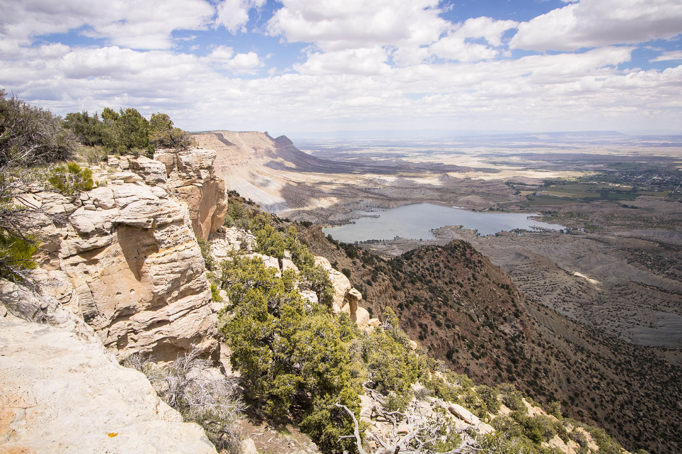
I made my way to the high point of Little Nelson Mountain, now on very tame terrain. There was a lot of cryptobiotic soil along the final quarter mile to the high point, but I could avoid it for the most part by sticking to the rim. The view south toward the hulking lump of Nelson Mountain and to the east down toward the Millsite Reservoir were really nice. To the west was a green expanse, while the east was flat desert. I hung out at an overlook just past the summit for a bit before heading back the way I came.
Please consider helping me out if you find my site useful. I'm not sponsored, so all site fees are out-of-pocket and my time preparing these trip reports is unpaid. You can also hire me as a web developer. I really appreciate it!


If you find my site helpful, please help me replace my many broken cameras, fund my website fees (hosting, APIs, security), or just support my countless hours of work. I pay for all expenses myself, and all trip reports I post are unpaid and unsponsored, so any support is really appreciated!
If using PayPal, please select their option for "Sending to a friend" so they don't take out fees, thank you.
My site is free to use, but consider sending me a few bucks to help keep it running. Thanks in advance!