I provide a free route map, but you can also download a hike/drive GPX to assist you and to help support my site. Before sharing my GPX tracks with others, please remember my site is a free resource and I'm charging nominal fees to offset my substantial costs.
GPX track added to your cart.
Mar 03, 2019 — 2021 Update: While this is a nice loop, you might want to check out the more extensive exploratory route of the Fire Range here, which we called "The Ring of Fires". It's a much more committing and serious route, but might help in planning a trip to the area.
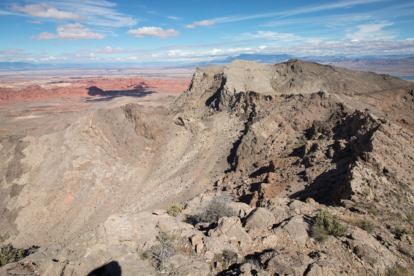
I've been hoping to plan a route in the Fires, hitting some of the high points in this lesser-visited small range, and set out without really doing enough homework. Fortunately, the route-finding gods were feeling merciful, and I was able to persist through the whole traverse. Valley of Fire State Park seen from above is spectacular.
Starting from Northshore Road, head into the obvious and scenic limestone canyon and take the right fork. You'll pretty quickly be hit with a Class 3 dryfall obstacle, followed by a second Class 3 climb on the left just after pulling the lip of the dryfall. Continue up the surprisingly scramble-less canyon until it opens up and the canyon continues northwest. Rather than follow the canyon up to (what Harlan Stockman writes is a Class 4 dryfall), you can get to the ridge to the north by instead heading up a mostly mellow slope. Follow this ridge to North Fire East Peak and North Fire Peak, continue along the ridge to Bighorn Peak. The views of Valley of Fire State Park are really pretty amazing. Here's where I wish I did more research, though I honestly don't think any info exists on this descent. I decided to follow the ridge and look for a weakness on the right. When none came and I was only a couple hundred feet from the ground, I started getting a little worried I'd have to backtrack the whole traverse so far. There seemed to be other potential options higher up to head descend via the west face instead, but I really don't know. I continued along the ridge and finally saw a scary-looking route that could go: Class 4 on that lovely solid, sticky limestone I love so much. It worked. A few notes: the Class 4 down-scramble from Bighorn Peak can apparently be avoided by instead rappeling through the canyon that drains southeast then right-angles southwest from the summit to rejoin this route. Alternatively, you could bag Fire Benchmark first, leaving the Class 4 scramble as an up-climb rather than down-climb.
UPDATE: Adam Walker more recently did a version of this route, but instead of ascending Bighorn Peak, he was able to wrap around its north side and avoid the only Class 4 move. I didn't include this option in my map, but just letting anyone know that option exists somewhere if you want to keep the route at Class 3.
From the base of Bighorn Peak, locate a ridge to get up to Fire Benchmark (Class 2) and from the summit, where you get great views of everything, head down the standard east ridge (Class 2+/3) to get down to the road. There are a couple of tricky sections, including one area where you need to leave the ridge to avoid cliffs.
Please consider helping me out if you find my site useful. I'm not sponsored, so all site fees are out-of-pocket and my time preparing these trip reports is unpaid. You can also hire me as a web developer. I really appreciate it!


If you find my site helpful, please help me replace my many broken cameras, fund my website fees (hosting, APIs, security), or just support my countless hours of work. I pay for all expenses myself, and all trip reports I post are unpaid and unsponsored, so any support is really appreciated!
If using PayPal, please select their option for "Sending to a friend" so they don't take out fees, thank you.
My site is free to use, but consider sending me a few bucks to help keep it running. Thanks in advance!