I provide a free route map, but you can also download a hike/drive GPX to assist you and to help support my site. Before sharing my GPX tracks with others, please remember my site is a free resource and I'm charging nominal fees to offset my substantial costs.
GPX track added to your cart.
Aug 18, 2022 — Bald Mountain is a popular peak just off the Mirror Lake Highway since it has a well-maintained traill all the way to its summit. Aside from minor Class 2 along the last quarter mile or so, the hike just uses nice switchbacks carved into the bouldery southwest ridge of Bald Mountain. I passed at least two parties blasting music and intentionally spooked one of them with an abnoxiously joyful "hi!". At the top I enjoyed the view toward Hayden Peak to the northeast before continuing off-trail toward Reids Peak, which is kind of just a big, steep rocky lump on the northwest side of Bald Mountain.
I started down the north ridge of Bald Mountain, which quickly increased in steepness and difficulty. Large boulders forced slow movement, but no move exceeded Class 2. A bit before halfway down, I recommend dropping just left of the ridge crest in order to avoid a gnarly-looking rock outcrop that comes in farther on, which causes the surrounding slope to have excessive (and potentially Class 3) steepness. This is the only notable obstacle on the way to the saddle of Bald Mountain and Reids Peak.
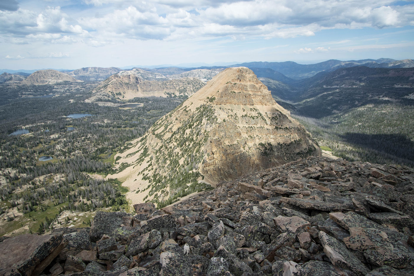
The ascent to Reids Peak began steeply, some minor bushwhacking to contend with if you can't locate one of the social trails. Keeping just left of the crest, I was able to avoid a long rocky outcrop by keeping along its base. A few hundred feet up got me to a flatter section where the cliffy ridge crest dissipated for a bit, opening up a view toward Reids Peak's formidable east face, which gave the route a scarier vibe than it actually ended up being. At the end of this flatter section I was confronted with a blocky rock outcrop, and a choice. Keeping left had obvious cairns, but didn't seem to gain much elevation. Ultimately that route does lead to the summit via a sloped ledge, followed by a steep Class 2/3 talus/scree slope. I included photos of this option, but excluded it from my map. The better option requires a short Class 3 section to keep ascending, then following a straightforward ledge and slope to keep more-or-less along the ridge crest when possible. This led to the summit without too much hassle or loose, scary crap.
After backtracking from Reids Peak to its saddle with Bald Mountain, I descended south on a steep, grassy slope with some light brush. There were a couple of small cliff bands that, with careful route-finding, can be kept Class 2/2+. Once at the base of the descent, I started generally south through pretty tundra, passing tarns and wildflowers as I made my way toward the Notch Mountain Trail. A couple of minor Class 2 obstacles (some boulders, a small cliff, etc.) and a short bout of forest walking got me to the trail, which I followed back to my car.
Just across the highway is a small peak called Murdock Mountain. It's a short walk from the trailhead, but you could drive and park at a pull-out, which would reduce my hike stats by about 0.8 mi. I started from the highway and entered the sparsely-vegetated forest, no trail to be found. The grassy slope abruptly transformed into somewhat annoying rocky terrain, which lasted for about a half mile to the wide summit area. I was interested in getting a dramatic view of Hayden Peak from Murdock Mountain's summit since it appeared to offer a nice overlook, but this wasn't the case. It was a cute little add-on, regardless.
Please consider helping me out if you find my site useful. I'm not sponsored, so all site fees are out-of-pocket and my time preparing these trip reports is unpaid. You can also hire me as a web developer. I really appreciate it!


If you find my site helpful, please help me replace my many broken cameras, fund my website fees (hosting, APIs, security), or just support my countless hours of work. I pay for all expenses myself, and all trip reports I post are unpaid and unsponsored, so any support is really appreciated!
If using PayPal, please select their option for "Sending to a friend" so they don't take out fees, thank you.
My site is free to use, but consider sending me a few bucks to help keep it running. Thanks in advance!