I provide a free route map, but you can also download a hike/drive GPX to assist you and to help support my site. Before sharing my GPX tracks with others, please remember my site is a free resource and I'm charging nominal fees to offset my substantial costs.
GPX track added to your cart.
Feb 26, 2022 — Carter Peak and Vernon Bailey Peak are an interesting pair of peaks that hug a popular feature called "The Window" in Big Bend National Park. Carter Peak is significantly lower than Vernon Bailey, but both require a similar approach and made sense to do together. Most would probably prefer to hike to these peaks via The Window Trail out of Chisos Basin, but I was more excited to approach from the west instead via the Oak Spring Trail. This would add a few easy miles and a little bit of vertical gain, but it had more benefits that made it a worthwhile choice. It reduced the number of people I'd see since the Oak Spring Trail is much less popular than The Window Trail, it would allow me to check out a different area of the park, and most importantly, I could scope the west face of Vernon Bailey Peak for a potential route. Going into this hike I only had some vague understanding that there might be a route up either peak, but ultimately the route-finding ended up not being too cryptic. Also, I had just done Picacho Peak, and approaching from the west made more sense than driving all the way into Chisos Basin.
I certainly underestimated the difficulty of this outing, and did not bring enough water. This resulted in me getting baked on the bright white scree of Vernon Bailey Peak and getting a bit more concerned than I ever have been about potentially passing out. Fortunately it never got to the point that I needed to turn around, but in hindsight I probably should have. I might be getting a bit complacent with desert outings, so this was just a rough awakening to always bring more water than anticipated in the desert.
My itinerary would end up being to first hike to The Window to check out what the hubbub was about, then go to Carter Peak, and finally wrap up the day with Vernon Bailey Peak. The hike starts by following a dumb gravel road for a few miles as it approaches the epic-looking peaks. Carter Peak looked especially incredible, its west face a sheer drop. The Oak Spring Trail eventually popped in on the left, marked by an old sign and taking me away from the road. The trail ascended pretty directly toward the base of Vernon Bailey Peak, and I got a really nice view of the watercourse coming down from The Window. The Oak Spring Trail made a few switchbacks and then wrapped beneath some rock outcroppings, the construction required for this trail clearly significant. The Oak Spring Trail then dropped a couple hundred feet down to the junction with The Window Trail.
I took the Window Trail back west as it descended through some pretty narrows, complete with carved staircases and benches. I was sort of expecting a natural arch or something once I reached The Window, but it's just a slick section of short narrows with an overlook to the desert below. Of course it's pretty, but wtf is with naming a simple water pour-off "The Window"? Anyway, done with this short excursion, I backtracked along the Window Trail a bit and continued east up the canyon in search for a route up Carter Peak.
My previous research of a satellite map revealed what looked like a scree field that I could possibly use to reach Carter Peak, and when I approached this scree field I was very surprised to see a clearly human-eroded social trail leading up the left (south) side of it. Happy to know there was an established route, I left the Window Trail, crossed the dry watercourse, and ascended to the start of the social trail. Easy, steep hiking led to steeper and more loose Class 2 terrain. There's definitely the potential for creating small rock slides here, so I took my time and attempted to ascend on larger boulder rather than the small, loose scree when possible. 600+ vertical feet of this and I made it to a minor saddle above, the start of the ridgeline to Carter Peak. A social trail continued for a bit, but it was hard to follow and I recommend just sort of ascending just to the left of the ridge crest when the social trail isn't discernible.
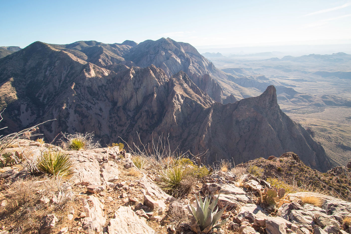
A bit of Class 2, some side-hilling and light bushwhacking, and a single (and possibly avoidable) Class 3 move to get over a minor cliff band got me to the final ridgeline to the base of Carter Peak. Here was an absolutely stunning perspective of the peak. It rises above the ridgeline like a needle, the drops on either side sheer and impressive, but there's no exposure along the ridge. Unfortunately the scramble up to the summit isn't as cool as it appears from below, a bit loose and brushy and never exceeding Class 2+. A key chute toward the summit facilitates a safe ascent. The 360 degree views made Carter Peak absolutely incredible, though. I could see Chisos Basin to the east, the sheer drop to the west, unnamed peaks and complex terrain to the south, and the foreboding Vernon Bailey to the north (my next peak). I tried to puzzle out a route from here with no luck. It looked like a big, steep, impossible pile of chaos. I got moving, realizing how late it was getting already and only now realizing Vernon Bailey would add another 2000+ vertical gain to the day.
I backtracked along the Window Trail, back up the Oak Spring Trail, and then reached the first switchback. I took a second to convince myself I wanted to go for Vernon Bailey before leaving the trail and entering the expansive talus/scree field on the west face of the peak. My first mission was to reach the base of Vernon Bailey's sheer western cliffs, and from there I'd wrap left (north) around them and hopefully locate more options farther up. Some bushwhacking took me to what appeared to be a clear talus field. On the ascend this talus field proved to be quite nice, pleasant Class 2 scrambling on solid boulders. For the descent, I took a scree slope down just to the north, but that would have been horrible as an ascent. My attached map shows the ascent route I took. After 500+ feet of boulder-hopping I got to the base of the cliffs. Scree/talus continued steeply around the cliffs, and then when I rounded the bend I saw that it just kept going. In fact, it actually became steeper and less pleasant. In total I'd be on a scree/talus field for over 1000 feet of vertical gain. It was also around this time that I ran out of water and realized I was immensely sunburnt. So that was cool.
Toward the top of the scree field I was very upset to realize there was a major cliff and prepared myself for the what seemed to be the inevitable turn-around point. However, a fortuitous chute on my right provided some hope. This brushy, horribly loose chute had more scree, but also introduced cacti and big agave. A couple hundred feet of ascending got me to a chockstone toward the top of this chute. On the right was a steep, dirty wrap-around with plenty of dumb brush to contend with. I also noticed what seemed to be a light social trail eroded into the dirt. Was this an established route? I really hoped so.
Past the chockstone the chute opened up a bit, and then I was confronted with two options. Left brought me into the sun and to the base of a scary-looking face. To the right didn't seem much better, but at least it was out of the sun. Fortunately this worked out great, Class 2 and of course more scree taking me through brush and up to a wide and brushy slope. Ahead I could see a single pinnacle which formed a notch next to a more substantial cliff. I didn't know it yet, but this notch was the key to the summit. Getting there required more steep slope crawling through brush. I first tried the right side of the pinnacle and was cliffed out, then attempted the narrow chute through the notch and was rewarded with more progress. A short dip while hugging the cliffs took me safely to a section of Class 2/2+ scrambling (finally, some decently solid rock!) and ultimately to the final slope. The ascent slope was light Class 2 and riddled with agave landmines, but it got me up to the summit of Vernon Bailey Peak! While the summit views were thwarted by the curvature of the peak, looking down at Carter on the way up was pretty cool.
Vernon Bailey was definitely a bit of a poor choice with my deteriorating energy level from dehydration, and it was certainly a desert adventure peak, if not a particularly fun one. I was also happy to be alone on this route, because every step of the way I saw the potential for rockslides, and I certainly dislodged more than one cactus or boulder.
Please consider helping me out if you find my site useful. I'm not sponsored, so all site fees are out-of-pocket and my time preparing these trip reports is unpaid. You can also hire me as a web developer. I really appreciate it!


If you find my site helpful, please help me replace my many broken cameras, fund my website fees (hosting, APIs, security), or just support my countless hours of work. I pay for all expenses myself, and all trip reports I post are unpaid and unsponsored, so any support is really appreciated!
If using PayPal, please select their option for "Sending to a friend" so they don't take out fees, thank you.
My site is free to use, but consider sending me a few bucks to help keep it running. Thanks in advance!