I provide a free route map, but you can also download a hike/drive GPX to assist you and to help support my site. Before sharing my GPX tracks with others, please remember my site is a free resource and I'm charging nominal fees to offset my substantial costs.
GPX track added to your cart.
Feb 27, 2022 — Elephant Tusk is an iconic Big Bend National Park peak, but it's usually only seen from the South Rim by Chisos Basin hikers or from the dirt roads surrounding the peak. Despite being so epic-looking, I might have lied to you already by calling it iconic. From a visual and scambling perspective it should be, but very people would even notice it on the skyline, and even fewer know its name. I don't believe the summit sees many ascents, partially likely because there is very little information about the peak as far as I could find. This incredible volcanic plug pokes into the sky and caught my attention almost immediately after spotting it on a topo map. For my final day in Big Bend I knew I had to at least attempt this massive hunk of rock or it would nag at me for years.
My adventure began by attempting to get to the closest trailhead I could find, which would start from the Elephant Tusk Campground (29.1269, -103.20707) and head along the Elephant Tusk Trail. However, I reached the start of Black Gap Road and was pretty much immediately shut down by its horrible state. Should I walk this 5-mile section of bad road just to get to the trailhead? That sounded dumb. I bitterly took a minute to finish my coffee and decide what I wanted to do. Despite the lack of cell reception, I had fortunately downloaded an area map and could inspect the trail system to formulate an alternative. What I settled on is the route outlined here, which follows a combination of trails and off-trail travel to reach the base of Elephant Tusk. This route adds about 6 miles and at least 1000 vertical to the day, but it's a much more accessible route and has the bonus of an extra summit, Tortuga Mountain. Plus, the Elephant Tusk Trail coming from the south seemed pretty boring and flat, while this one was a bit more adventurous and interesting. I thought it worked out quite well.
I drove up Juniper Canyon Road to its end (passable by Crossover vehicles), where I could start my hike along the Dodson Trail. I spent some of my day yesterday on the western portion of the Dodson Trail to reach Picacho Peak, so it felt fitting to check out the eastern portion today. The Dodson Trail was in good shape overall, and it seems to get a bit of traffic. I passed three parties in total, all backpackers. The trail descends slowly to the south before turning and climbing slowly to the west as it leads up a drainage. I wouldn't say it's a particularly remarkable hike to this point, but I was happy to have a nice warm-up after getting my butt kicked by the sun yesterday. The Dodson Trail made its sweet time up to a small saddle directly north of Tortuga Mountain, where the views finally opened up a bit.
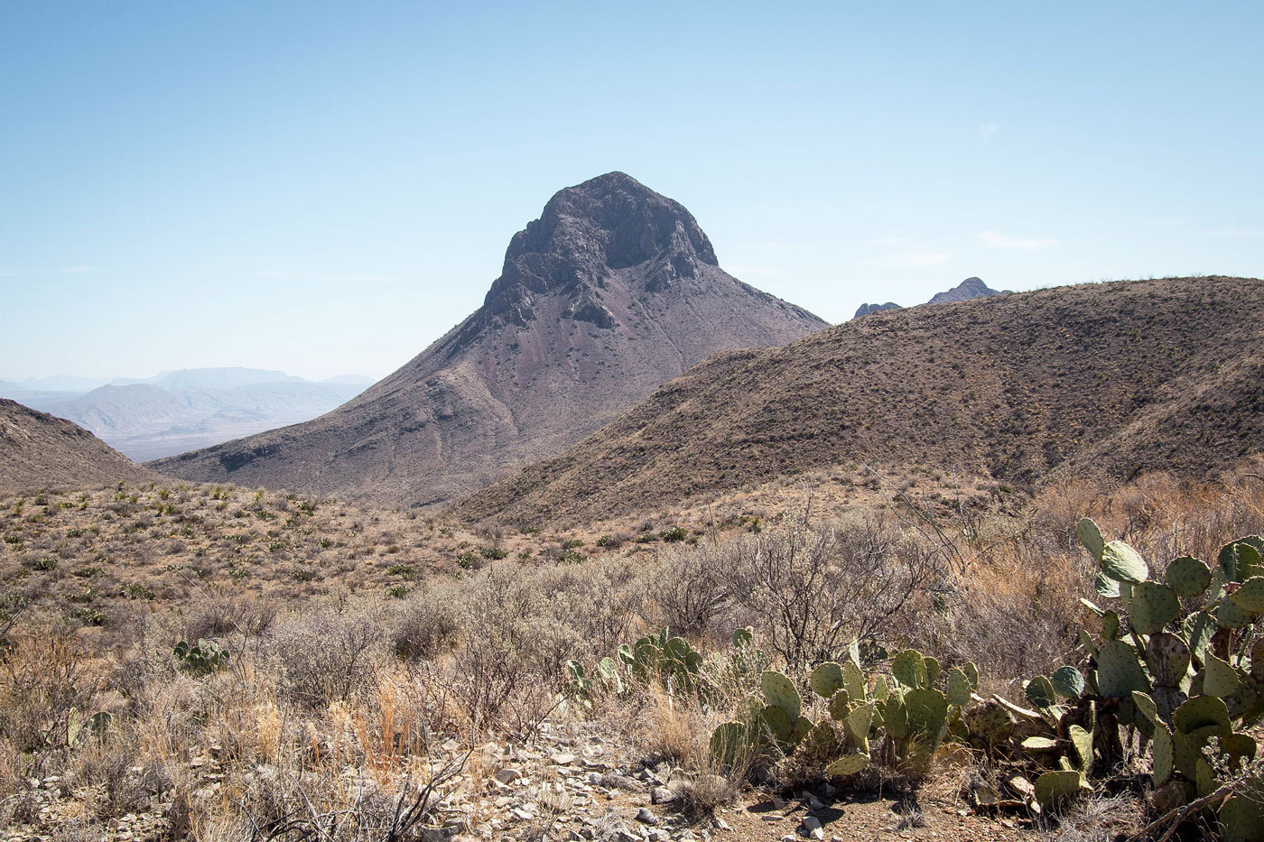
From this small saddle the Dodson Trail starts to descend again to the west, but that wasn't where I was going. Instead, my goal now was to reach the Elephant Tusk Trail to the south. I supposed I could continue along the Dodson Trail and pick up the Elephant Tusk Trail in a couple of miles, but this would add a significant distance to the day. I chose instead to leave the trail and head south toward Tortuga Mountain. From there I could drop down and join the Elephant Tusk Trail. The brush along the northern ridge of Tortuga Mountain wasn't bad, though the last few hundred feet to its summit was a bit steep and had some light Class 2. I was awarded with my first unobstructed view of Elephant Tusk, still miles away. I gawked at its shadowy form and had that giddy mixture of excitement and fear.
I dropped off the steep Class 2 west ridge of Tortuga Mountain and ended up on the Elephant Tusk Trail, which was really just the watercourse. I followed the watercourse south and then kepy right (west) at a confluence. According to my map, the Elephant Tusk Trail should be right where I was standing, but it wasn't. The official Big Bend National Park map doesn't include the Elephant Tusk Trail, but other resources showed that it does. This could mean it's no longer maintained, my slow brain started to realize, and I could be bushwhacking for miles. Without getting too annoyed just yet, I spent a few minutes walking back and forth in the watercourse looking for the trail, eventually (and relieved) locating it on the left, marked by a cairn. I marked this spot on my attached map.
While not as pleasant as the Dodson Trail was, the Elephant Tusk Trail was mostly easy to follow. At points it disappeared completely, but cairns helped guide me and overall I didn't get too scratched up from encroaching cacti and brush. The trail led up to a minor saddle, south along a slope, and then descended into a significant drainage. This drainage had a short narrow section as well as some interesting walls. Once the wash opened up and I could see Elephant Tusk clearly ahead of me, I left the drainage and ascended south up toward the peak's northern ridge.
Although my approach so far was non-standard, I would soon merge with what I could collect from online about the actual climb (mostly from Gerry Roach). There's a massive chute on the northeast side of Elephant Tusk that I couldn't see yet since I was coming from the north, so I side-hilled on scree at the base of the peak's northern cliffs for a few hundred feet until this chute came into view. Some Class 2 scree slogging took me up the progressively steeper and more narrow chute. I noted significant erosion, likely from other parties and sheep, so that made me feel better. At the top of the scree slope the chute narrowed into a tighter section at the base of the crux. I looked up at this crux, a Class 4 chimney-like set of moves that would last around 25 feet. Fortunately it's not exposed and I was confident I could stem my way up. The chimney is slightly flared out, so I was unable to stem the whole way, switching to climbing toward the top. The rock quality isn't horrible, but I don't recommend blindy trusting anything. Even larger holds that seem solid were certainly not, wiggling upon receiving any pressure. At the top of the chimney is a notch where a belay station was rigged with plenty of webbing: messy, but safe-looking (as of February 2022).
The fun had just begun! Past the crux I started up the steep northern ridge and ascended about 400 feet of Class 2/2+ with the occasional Class 3 mixed in. The micro-route-finding is fun and more than once I had to play around with other potential options to avoid scarier, unnencessary moves. There may be easier options on the right, but it seemed more loose and dirty and I was enjoying myself on the ridgeline. The rock quiality is overall not excellent, but the holds were good where I needed them. However, it's a very steep few hundred feet and while not exactly exposed, a fall could be quite bad. As I neared the top of the ridge I came across what I felt was a second crux, where a series of Class 3 moves wrapped to the right around a significant outcropping.
I made it to the final bit of fun, a Class 2/2+ wannabe-knife-edge that stretched for a couple hundred feet and led up to the summit. Now on the summit of Elephant Tusk, I took in the views and admired the many Big Bend National Park peaks from this unique vantage point. I felt I had achieved the majority of the things I wanted to do in the park for now and this felt like an excellent finale to my trip.
I backtracked from Elephant Tusk's northern ridge, usually taking the exact same route as on the way up, but I was able to cut out a few Class 2/3 moves here and there now that I was more familiar with the terrain. I'd still say the ridge is Class 3, and moving slowly is probably prudent.
After returning to the base of Tortuga Mountain, rather than reascend the peak I decided to take a canyon to its west. Overall there wasn't much brush, but there was a small section where a pretty little spring caused lots of vegetation growth that I needed to wrap around. I made my way back up to the Dodson Trail and headed back to my car.
Please consider helping me out if you find my site useful. I'm not sponsored, so all site fees are out-of-pocket and my time preparing these trip reports is unpaid. You can also hire me as a web developer. I really appreciate it!


If you find my site helpful, please help me replace my many broken cameras, fund my website fees (hosting, APIs, security), or just support my countless hours of work. I pay for all expenses myself, and all trip reports I post are unpaid and unsponsored, so any support is really appreciated!
If using PayPal, please select their option for "Sending to a friend" so they don't take out fees, thank you.
My site is free to use, but consider sending me a few bucks to help keep it running. Thanks in advance!