stav is lost logo
  • Find Hikes
    • Most recent
    • Trip Report Index
    • Hikes by Region
    • Search Hikes
  • Map
  • About
  • Love
Hike Fletcher Canyon in Spring Mountains National Recreation Area, Nevada - Stav is Lost

Hike Fletcher Canyon Spring Mountains National Recreation Area, NV

Class 1 4.1 miles 900 gain 1-2 hr Out and Back
Effort
Beauty
Personality
Solitude
DirectionsRoute MapDownload GPX

Fletcher Canyon GPX Track

I will always provide a free route map, but you can also download a hike/drive GPX to assist you and to help support my site. Before sharing my GPX tracks with others, please remember my site is a free resource and I'm charging nominal fees to offset my substantial costs.

GPX track added to your cart.

Add to Cart ($2.50)
View Cart

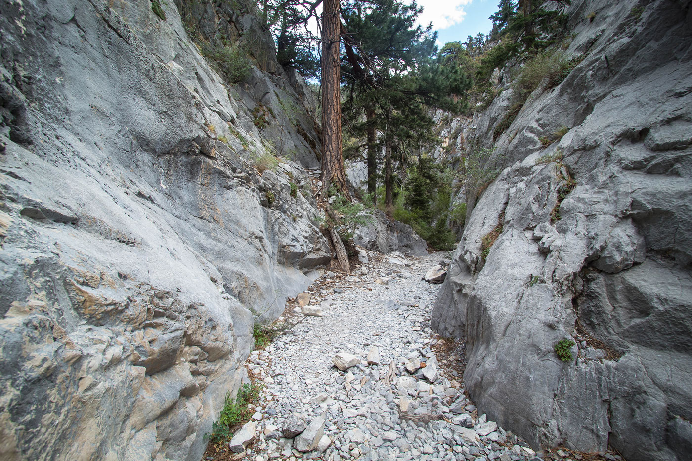
Jul 05, 2021 — A nice trail leads a but under two miles to the mouth of Fletcher Canyon. It's well-marked and fairly popular. As the canyon begins to narrow, it's a little difficult to follow the official trail which stays mostly to the south side of the canyon. Some seem to choose to head through the watercourse rather than stick to the trail, which means other social trails have materialized. Either way there's no bushwhacking to worry about. Fletcher Canyon continues to narrow and becomes more pretty as it progresses, the limestone walls colorful and the foliage within the canyon more lush than expected. The trail ends at a junction within the canyon.

While I didn't include it on my attached map, you can pull a Class 3 move within the right fork of the junction past the end of the trail and explore farther into the canyon. My first visit was April of 2015 and I left some photos at the end of my trip report from the upper portions of the canyon, if you choose to check it out.

Show me some love

Please consider helping me out if you find my site useful. I'm not sponsored, so all site fees are out-of-pocket and my time preparing these trip reports is unpaid. You can also hire me as a web developer. I really appreciate it!

Thank you

Next HikePrev Hike
  • Next Hike
  • More Near Here
  • Prev Hike
photo protector Fletcher Canyon Trailhead.
Fletcher Canyon Trailhead.
photo protector A nice trail at the base of the Spring Mountains.
A nice trail at the base of the Spring Mountains.
photo protector Junction with the Eagle's Nest Loop Trail.
Junction with the Eagle's Nest Loop Trail.
photo protector Entering Mount Charleston Wilderness.
Entering Mount Charleston Wilderness.
photo protector View along the Fletcher Canyon Trail of the limestone cliffs above.
View along the Fletcher Canyon Trail of the limestone cliffs above.
photo protector The trail enters a more forested section.
The trail enters a more forested section.
photo protector View back along the trail.
View back along the trail.
photo protector The foliage gets a bit more dense when nearing Fletcher Canyon's mouth.
The foliage gets a bit more dense when nearing Fletcher Canyon's mouth.
photo protector Entering the canyon mouth.
Entering the canyon mouth.
photo protector View back.
View back.
photo protector Entering Fletcher Canyon.
Entering Fletcher Canyon.
photo protector At first the walls are very tall and colorful.
At first the walls are very tall and colorful.
photo protector Then there's a short section of hiking through a wider portion of the canyon.
Then there's a short section of hiking through a wider portion of the canyon.
photo protector No caption.
photo protector View back into the wider section.
View back into the wider section.
photo protector And the Fletcher Canyon narrows up.
And the Fletcher Canyon narrows up.
photo protector The walls are less tall, but the slot is narrower.
The walls are less tall, but the slot is narrower.
photo protector No caption.
photo protector View back the way I came through the slot.
View back the way I came through the slot.
photo protector No caption.
photo protector The end of the trail is at this junction.
The end of the trail is at this junction.
photo protector I kept right at the junction and in 2015, scrambled up the Class 3 moves ahead.
I kept right at the junction and in 2015, scrambled up the Class 3 moves ahead.
photo protector View from the side canyon past the end of the trail. The next few photos are remnants from my visit in 2015.
View from the side canyon past the end of the trail. The next few photos are remnants from my visit in 2015.
photo protector 2015: Close-up of some pretty canyon features.
2015: Close-up of some pretty canyon features.
photo protector 2015: A shot past the end of the trail after pulling a Class 3 move
2015: A shot past the end of the trail after pulling a Class 3 move
photo protector 2015: A stream carving into the rocks in Fletcher Canyon (past end of trail).
2015: A stream carving into the rocks in Fletcher Canyon (past end of trail).
photo protector 2015: Past the end of the trail.
2015: Past the end of the trail.

Show Me Some Love

If you find my site helpful, please help me replace my many broken cameras, fund my website fees (hosting, APIs, security), or just support my countless hours of work. I pay for all expenses myself, and all trip reports I post are unpaid and unsponsored, so any support is really appreciated!

If using PayPal, please select their option for "Sending to a friend" so they don't take out fees, thank you.

PayPalVenmoCash App

About  Contact  Love

© 2023 Stavros Basis.

DISCLAIMER: All activities you find on this site are dangerous. I am not responsible for anything you do in the outdoors. Please practice good ethics, and don't take any risks that put yourself or others in danger.


Thanks for visiting!

My site is free to use, but consider sending me a few bucks to help keep it running. Thanks in advance!

Sure!Nope.