I provide a free route map, but you can also download a hike/drive GPX to assist you and to help support my site. Before sharing my GPX tracks with others, please remember my site is a free resource and I'm charging nominal fees to offset my substantial costs.
GPX track added to your cart.
May 16, 2021 — Indian Peak is a really nice mountain in a very remote area of Utah. Pine Valley Road, the main dirt road thats runs north to south through the valley and is used to access the area, is in amazing shape. If coming from the south, the turn off to reach Indian Peak is here (38.21361, -113.67103), and this road to the trailhead is likely passable by any vehicle, though passenger cars might be a little cautious on a few short spots. If coming from the north, the turn off from Pine Valley Road is here (38.32677, -113.722), and this road is great except for a couple of rough spots that passenger cars likely can't do. Either way, the trailhead was less work to reach than anticipated, but I felt like I was driving forever. There's no gas for 70+ miles in all directions.
I chose this trailhead because the northern route that seems more commonly completed looked steep and brushy, while this route included a social trail and very light brush. I don't know how the northern route is, but this route was lovely and I definitely recommend it. I started from my parking spot and headed west along the remains of an old jeep road. The road ended shortly after at a jumble of tracks within a wide gully, and I thought for a moment I'd be bushwhacking. However, with a tiny bit of poking around I located an unmarked trail that was obvious enough to make me feel confident to follow it through the forest. This trail was excellent and I have no idea why. It's not marked on any maps I could find, but for the first half mile is as good as any maintained trail in Utah. The trail became a little more difficult to follow for a hundred feet or so before reaching a clearing, where animals seem to switchback up a steep section. At this clearing was a spring with some sort of wilderness monitor. Like the doofus I am, I waved at the camera before continuing west through the clearing. Animals have carved a really nice trail through the wide and open gully, and I had no problem getting to the south side of Indian Peak.
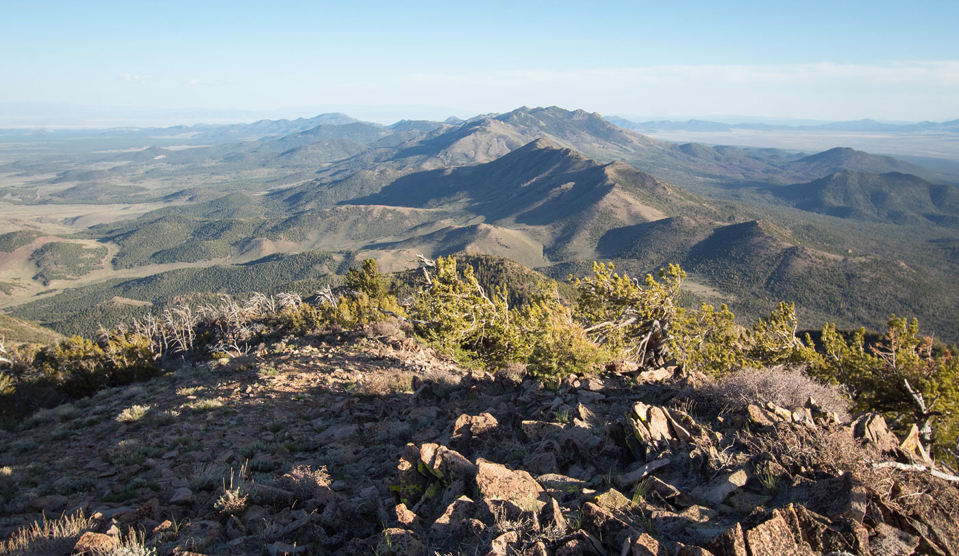
Once at the south side of Indian Peak, I was happy to find the steep ascent slope would be a mostly pleasant endeavor. When viewing a satellite map, it's hard to tell quite how bad brush will be, and this section had me slightly concerned. However, the slope had animal trails leading all over the place and the brush was easily avoidable. I followed the animal trails through the brush and had no issues getting up to a fence, except of course for a half dozen ticks crawling up my legs. I'll note that it might be tempting to head directly to the ridgeline to the west from within the gully, but the ridgeline is tree-covered and I can't imagine it's easier than the route I took. I followed the fence north and it brought me up to the final ascent slope leading to the summit of Indian Peak. The views were really amazing, particularly the hills to the south. I returned the way I came.
Please consider helping me out if you find my site useful. I'm not sponsored, so all site fees are out-of-pocket and my time preparing these trip reports is unpaid. You can also hire me as a web developer. I really appreciate it!


If you find my site helpful, please help me replace my many broken cameras, fund my website fees (hosting, APIs, security), or just support my countless hours of work. I pay for all expenses myself, and all trip reports I post are unpaid and unsponsored, so any support is really appreciated!
If using PayPal, please select their option for "Sending to a friend" so they don't take out fees, thank you.
My site is free to use, but consider sending me a few bucks to help keep it running. Thanks in advance!