

After leaving the suburb, we started along this old roadbed, which shortly after turned into a social trail. Our first objective is the weakness in the center of this photo. Mount Allgood visible left of center, Johnson Mountain far right, Middle Johnson right of center. First we would have to overcome a minor cliff band, seen center.
A weakness in the smaller cliff band lower down. Allgood left, Middle Johnson right.
Class 2/3 on the steep slope.
View back at our progress. West Temple in the distance, Springdale below.
Approaching the Class 3 weakness.
Class 3.
View back down the start of the scramble through the weakness.
Class 3 with some route-finding to keep the route tame.
View back, the steep slope from Springdale we came up on visible on the right.
At the notch separating Allgood from Middle Johnson, view back toward Springdale.
At the notch, view toward The Watchman. We had to find a somewhat tricky route down into the drainage below separating Johnson Mountain from The Watchman.
Class 3, nearing the drainage.
Within the drainage canyon, a short Class 3+ stemming move through a tiny slot.
Mostly sandy wash.
We left the wash to ascend Johnson Mountain. This is a view back the way we came, The Watchman visible top right.
Navigating potentially tricky terrain to reach the base of Johnson Mountain. There are likely many route options to escape the drainage and ascend to the base of the peak.
Class 2 stuff along the base of Johnson Mountain.
Johnson Mountain's east face comes into view! It looks impossible from here. We wrapped basically all the way to the left, keeping pretty low. Surprisingly, the summit not the sheer face, but instead on the right in this photo.
Some Class 2/3 obstacles as we wrapped to Johnson's southeast face.
Mostly it was tame terrain.
View up at Johnson Mountain (top right). We'll be up there on that tree-filled ledge shortly. We couldn't find an easy way up from here, so we continued wrapping to the left (south) around Johnson Mountain.
Still wrapping around the peak's base to avoid the serious cliffs.
We saw this broken section of cliffs and ascended here, a Class 2/3 slope on the southeast side of the peak.
Farther up, some Class 3 on solid sandstone slickrock.
View back at our progress up the weakness.
Class 4 move to get out of the chute/slope we ascended.
View back at the chute we ascended.
Luke pulling the short Class 4 move.
Past the move, we were higher up now on the tree-filled ledge mentioned earlier. It was a nice ledge, wide enough to feel safe.
View back along the ledge.
We got to the major crack separating the false sheer-looking peak from the true summit. It certainly wouldn't go. We continued to the right on the ledge.
View back again along the ledge.
Still pretty straightforward along the ledge.
A Class 3/4 slope sandstone section. Once above this, we wrapped to the right and encountered an exposed move.
Top of the Class 3/4 sloped sandstone section, view back along the ledge we hiked along earlier. Just past this is the exposed move.
Exposed Class 3 move. We were below Luke earlier. As you can see the cliff is pretty sheer and I can't imagine another way up.
Past the exposed move, another ledge that passed some eroded caves.
View back toward the ledge with caves.
View back along the ledge, the eroded caves hidden behind Luke. There was some tricky Class 2/3 route-finding to get to the base of the summit block. We sure had to take our time on the way back in order to remember our route.
Johnson Mountain ahead, Class 2/3.
Base of Johnson Mountain.
Just below the summit, view toward the final section.
Johnson Mountain summit, view south.
Close-up south. You can see the sheer face that looks like the summit from below, but was in fact not.
Johnson Mountain summit, view north. Mount Allgood the little pinnacle below, The Watchman top right.
Close-up toward Springdale, Kinesava, and West Temple.
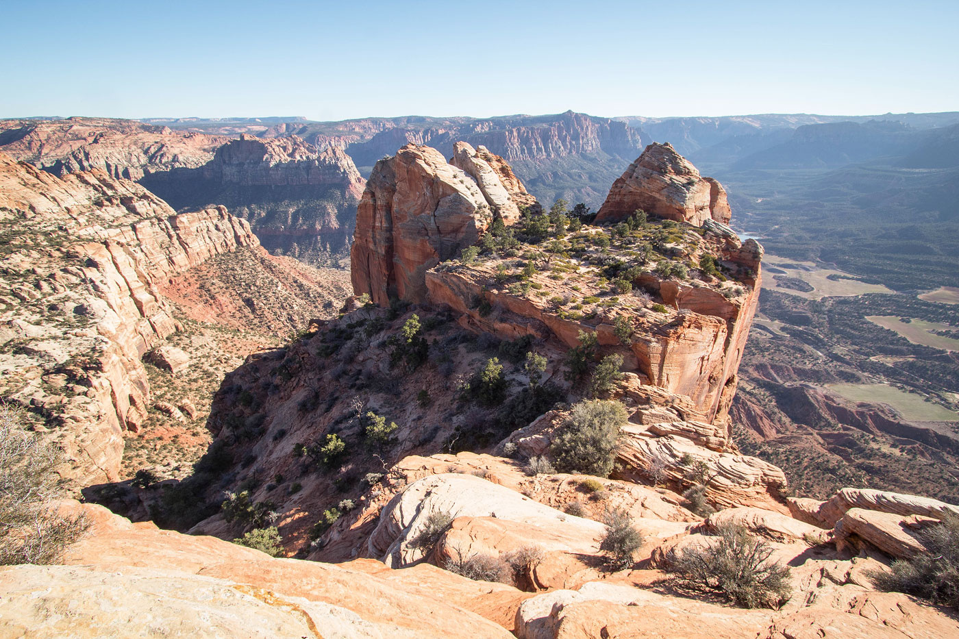
We descended from Johnson Mountain the wat we came and then decided to head to Middle Johnson, seen center. We were able to avoid dropping all the way down into the primary drainage separating Johnson and Watchman. Class 3 led down into the gully below, and then the wide sloped gully in the center of this photo led to just below the summit.
On our way up, a nice shot toward Johnson Mountain.
Close-up at our progress up the Class 2/3 slope/gully. The drainage separating Johnson and Watchman visible top left.
Class 3/4 crux move just below the summit of Middle Johnson.
Middle Johnson summit, view north toward Mount Allgood. We would wrap around Middle Johnson and take the ridge seen center here.
View south toward Johnson Mountain.
After wrapping around to the east side of Middle Johnson, we located a route avoiding the peak's scary cliff face, this nice Class 2 option. It led to the ridge separating Middle Johnson from Allgood.
Mount Allgood seen left of center, the drainage separating Johnson from Watchman visible right. Luke is navigating easier terrain.
Along the Class 3 ridgeline. Allgood ahead.
Toward the end of the ridge, we had to drop to the right (east) to avoid a drop-off. Class 3+.
Looking back just below the ridge crest on a somewhat exposed, nice ledge system.
Back at the notch separating Middle Johnson and Allgood (where we were earlier in the day), now ascending to Mount Allgood.
View back. Johnson visible distant top. The drainage separating Johnson and Watchman on the left. Notch we came up from on the approach earlier in the day just above Luke's head.
Class 2 to the base of Mount Allgood.
Just bellow Mount Allgood's summit, view toward Johnson Mountain.
Class 3 move to the summit.
Crux of Mount Allgood, Class 3.
Mount Allgood summit, view north.
Close-up into Springdale.
Mount Allgood summit, view south toward Johnson Mountain.
Hire me or show me some love!
Hire/refer me as a web developer or send me a few bucks if you find my site useful. I’m not sponsored, so all fees are out-of-pocket and my time preparing trip reports is unpaid. I really appreciate it!