stav is lost logo
  • Find Hikes
    • Most recent
    • Trip Report Index
    • Hikes by Region
    • Search Hikes
  • Map
  • About
  • Love
Hike Stansbury Island High Point in Stansbury Island BLM, Utah - Stav is Lost

Hike Stansbury Island High Point Stansbury Island BLM, UT

Class 3 7.4 miles 3000 gain 4-6 hrs Loop
Effort
Beauty
Personality
Solitude
DirectionsRoute MapGPX

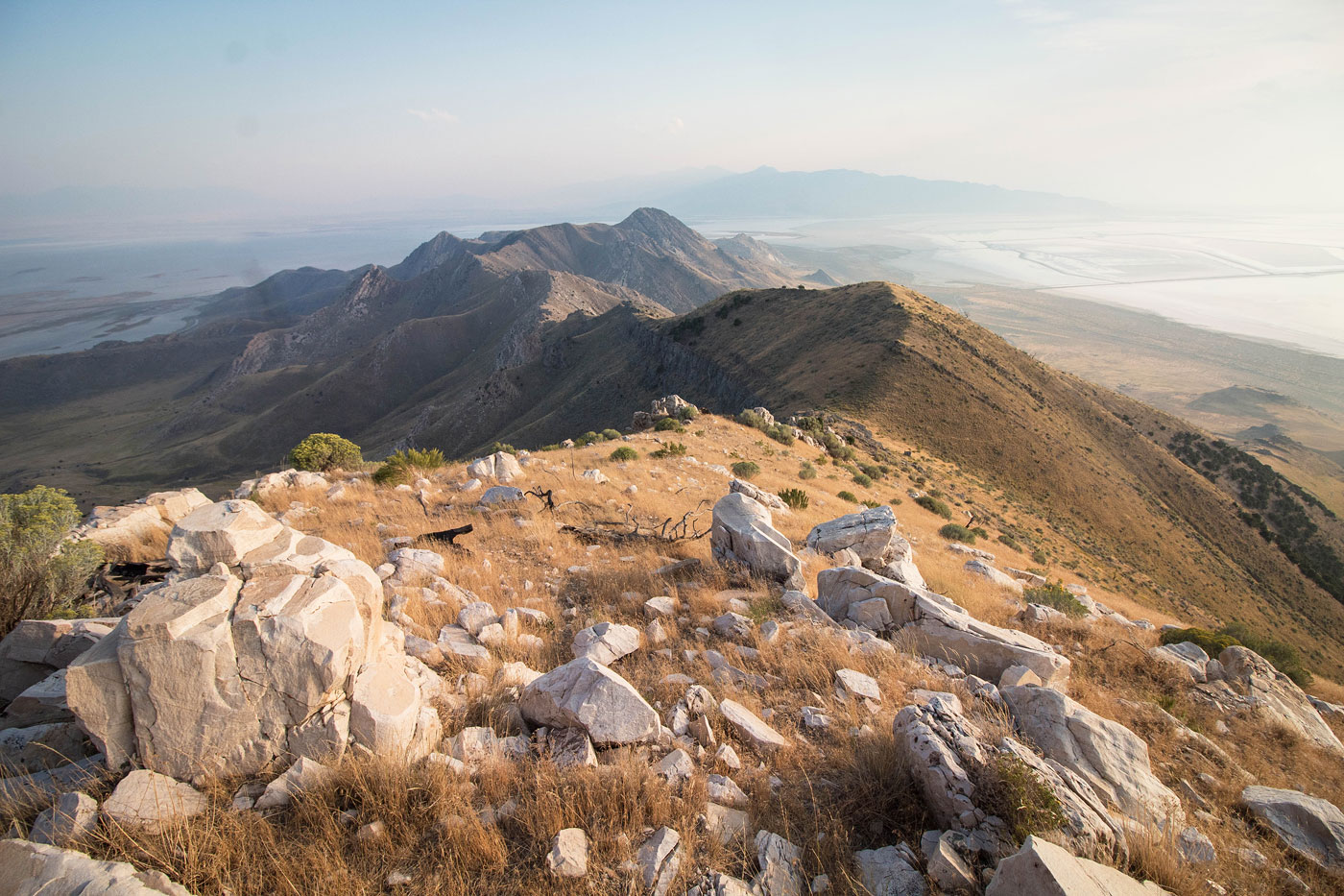
Sep 09, 2019 — Stansbury Island is beautiful island/peninsula on the Great Salt Lake, and it definitely rivals the beauty of the more popular Antelope Island. I actually preferred it because of the relative solitude. The route to the highest point of Stansbury Island is a little funky to get to because the region around the main road is riddled with private property and mining, so a round-about route is required to stay on public land. I won't claim that I went through private property on the way back, but the option is available and I've included this viable route in my map, but it's not recommended. Additionally, my route takes a somewhat more fun ridgeline ascent than what seems to be the standard, easier route (dotted blue line on the map).

Starting from a dirt road just off the main Stansbury Island road, I followed a fenceline to a rock outcropping, then trekked through the tall grasses along the western base of the foothills. After spending some time traversing north across the grasses, I located a ridge that I ascended east for a few minutes until getting to the remains of an old road system that weaves north along the foothill slopes. There's no "correct" route here, but overall I liked my choices as I wrapped around the base of the range and I would recommend it.

The old road started to curve east into a minor drainage, and it wraps even farther north before the standard route leads to the aforementioned saddle. Rather than continue on this old road, I decided to instead just head up the closest ridge to see what I would find. After a steep Class 2 shallow gully, I got to a random ridgeline with some fun Class 3 moves. It's short and sweet, and a nice addition to the day. If you want to keep the route a little easier, rather than heading up the shallow gully continue along the old road (follow the blue dotted line on my map). Both routes lead to the saddle to the south of Stansbury Island High Point.

Once on the ridgeline I continued north, encountering some Class 2 and then some really light Class 3 just before the summit of Castle Rock. The short traverse from Castle Rock to Stansbury Island High Point was a bit more spicy. A Class 4 headwall greeted me at the saddle of the two, but I opted to head to the left around this headwall in search of an easier and more likely route. The scrambling can get a little cryptic here, since the blocks are large and obscure the view of what's to come, and the route isn't totally obvious. A few bouldery Class 3 moves and some light route-finding around rock monoliths brought me to the grassy summit.

Like I mentioned, from the summit of Stansbury Island High Point, a light Class 2 route that's otherwise mostly just a grassy walk leads west to the dirt road used to enter Stansbury Island, but this is partially on private property and I dont recommend going this way, but that's the only reason I wouldn't recommend going that way.

PEAKS ON HIKE
Elevation (ft) / Prominence (ft)
Peaks on hike
Elevation
Prominence
1
Castle Rock
6600+ ft
20 rise
2
Stansbury Island High Point
6649 ft
2437 rise

Show me some love

Please consider helping me out if you find my site useful. I'm not sponsored, so all site fees are out-of-pocket and my time preparing these trip reports is unpaid. You can also hire me as a web developer. I really appreciate it!

Thank you

Next HikePrev Hike
photo protector A view toward Stansbury Island High Point, center, from the trailhead.
A view toward Stansbury Island High Point, center, from the trailhead.
photo protector I followed a fenceline as it led to the base of the range's grassy slopes.
I followed a fenceline as it led to the base of the range's grassy slopes.
photo protector Past the fenceline, I continued along the base of the slopes on overall pleasant, though grassy, terrain.
Past the fenceline, I continued along the base of the slopes on overall pleasant, though grassy, terrain.
photo protector I ascended the sloping spur ridge ahead.
I ascended the sloping spur ridge ahead.
photo protector View back through the grasses. My car is right of center at the base of the black hump.
View back through the grasses. My car is right of center at the base of the black hump.
photo protector After ascending the spur ridge, I made it to this old road.
After ascending the spur ridge, I made it to this old road.
photo protector View back along the road. My car is somewhere on the right.
View back along the road. My car is somewhere on the right.
photo protector Pretty view toward Stansbury Island High Point. The standard route (blue dotted line) heads along the base of the spur ridge in the center before ascending to the ridgeline.
Pretty view toward Stansbury Island High Point. The standard route (blue dotted line) heads along the base of the spur ridge in the center before ascending to the ridgeline.
photo protector Instead, I chose to ascend using this shallow gully in order to reach the ridgeline more quickly, visible center.
Instead, I chose to ascend using this shallow gully in order to reach the ridgeline more quickly, visible center.
photo protector Ascending the shallow gully.
Ascending the shallow gully.
photo protector View back as I ascend. You can see the old road I was just on in the center.
View back as I ascend. You can see the old road I was just on in the center.
photo protector Class 2 and then Class 3 along my chosen spur ridge.
Class 2 and then Class 3 along my chosen spur ridge.
photo protector View back.
View back.
photo protector Class 3 stuff, adding some fun.
Class 3 stuff, adding some fun.
photo protector Another shot back.
Another shot back.
photo protector I made it to the main ridgeline, Castle Rock top right.
I made it to the main ridgeline, Castle Rock top right.
photo protector View back along the ridgeline.
View back along the ridgeline.
photo protector I continued along the ridge.
I continued along the ridge.
photo protector No caption.
photo protector Some minor Class 2 as I ascended.
Some minor Class 2 as I ascended.
photo protector But most of the time it was grassy and straightforward.
But most of the time it was grassy and straightforward.
photo protector Another shot back at my progress.
Another shot back at my progress.
photo protector Rock outcrop obstacle along the ridge.
Rock outcrop obstacle along the ridge.
photo protector And more grassy ascending.
And more grassy ascending.
photo protector Castle Rock visible center.
Castle Rock visible center.
photo protector View back.
View back.
photo protector Castle Rock ahead.
Castle Rock ahead.
photo protector No caption.
photo protector Ascending the ridge to Castle Rock.
Ascending the ridge to Castle Rock.
photo protector I couldn't help myself with photos. The lighting was beautiful.
I couldn't help myself with photos. The lighting was beautiful.
photo protector Class 2 on the way up to Castle Rock.
Class 2 on the way up to Castle Rock.
photo protector View back at some Class 2.
View back at some Class 2.
photo protector Higher up along the ridge, looking back again. My car is somewhere right of center on the flat section of desert.
Higher up along the ridge, looking back again. My car is somewhere right of center on the flat section of desert.
photo protector Summit of Castle Rock, view toward Stansbury Island High Point.
Summit of Castle Rock, view toward Stansbury Island High Point.
photo protector Class 4 headwall. I avoided it by staying left.
Class 4 headwall. I avoided it by staying left.
photo protector Class 3 ascent option to get back onto the ridgeline, avoiding the Class 4 headwall. There are likely many options, but I liked this one.
Class 3 ascent option to get back onto the ridgeline, avoiding the Class 4 headwall. There are likely many options, but I liked this one.
photo protector Continuing along the ridgeline on interesting rock.
Continuing along the ridgeline on interesting rock.
photo protector View back.
View back.
photo protector Stansbury Island High Point ahead.
Stansbury Island High Point ahead.
photo protector Stansbury Island High Point, view back along the ridge.
Stansbury Island High Point, view back along the ridge.
photo protector Stansbury Island High Point, view north.
Stansbury Island High Point, view north.
photo protector Stansbury Island High Point, view west. If you choose to descent into private property (of course, not recommended), you'd head down the easy slope here.
Stansbury Island High Point, view west. If you choose to descent into private property (of course, not recommended), you'd head down the easy slope here.
photo protector The Great Salt Lake at sunset.
The Great Salt Lake at sunset.

Show Me Some Love

If you find my site helpful, please help me replace my many broken cameras, fund my website fees (hosting, APIs, security), or just support my countless hours of work. I pay for all expenses myself, and all trip reports I post are unpaid and unsponsored, so any support is really appreciated!

If using PayPal, please select their option for "Sending to a friend" so they don't take out fees, thank you.

PayPalVenmoCash App

About  Contact  Love

© 2023 Stavros Basis.

DISCLAIMER: All activities you find on this site are dangerous. I am not responsible for anything you do in the outdoors. Please practice good ethics, and don't take any risks that put yourself or others in danger.


Thanks for visiting!

My site is free to use, but consider sending me a few bucks to help keep it running. Thanks in advance!

Sure!Nope.