stav is lost logo
  • Find Hikes
    • Most recent
    • Trip Report Index
    • Hikes by Region
    • Search Hikes
  • Map
  • About
  • Love
Hike Stratton Mountain in Green Mountain and Finger Lakes National Forests, Vermont - Stav is Lost

Hike Stratton Mountain Green Mountain and Finger Lakes National Forests, VT

Class 1 7.8 miles 1700 gain 3-5 hrs Out and Back
Effort
Beauty
Personality
Solitude
DirectionsRoute MapDownload GPX

Stratton Mountain GPX Track

I will always provide a free route map, but you can also download a hike/drive GPX to assist you and to help support my site. Before sharing my GPX tracks with others, please remember my site is a free resource and I'm charging nominal fees to offset my substantial costs.

GPX track added to your cart.

Add to Cart ($2.50)
View Cart

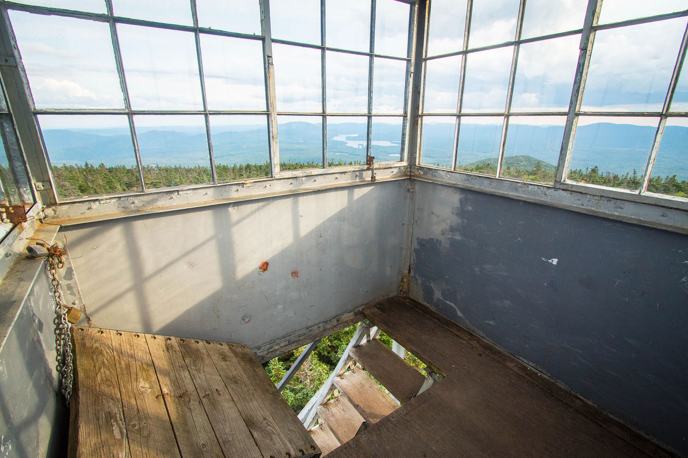
Jul 22, 2021 — The route I took to get to Stratton Mountain used the Appalachian Trail, coming in from the southwest. A bit popular for my taste, the hike leads through forest and slowly gains elevation, nothing particularly steep for the hike's entirety. The trail was even pretty well-manicured and had minimal rockiness, unlike much of the Appalachian Trail in this area. Even the last bit to the summit where the slope became more steep was made easy due to ample switchbacks. The summit has a fire tower, which offers the only views along the hike.

PEAKS ON HIKE
Elevation (ft) / Prominence (ft)
Peaks on hike
Elevation
Prominence
1
Stratton Mountain
3940 ft
2405 rise

Show me some love

Please consider helping me out if you find my site useful. I'm not sponsored, so all site fees are out-of-pocket and my time preparing these trip reports is unpaid. You can also hire me as a web developer. I really appreciate it!

Thank you

Next HikePrev Hike
  • Next Hike
  • More Near Here
  • Prev Hike
photo protector Starting up to Stratton Mountain from the trailhead.
Starting up to Stratton Mountain from the trailhead.
photo protector Well-manicured first mile or so.
Well-manicured first mile or so.
photo protector Passing a pond that I can't see from the trail.
Passing a pond that I can't see from the trail.
photo protector Not particularly interesting forested terrain.
Not particularly interesting forested terrain.
photo protector No caption.
photo protector Yeah, it's not exactly the most exciting hike. The trail isn't steep and it's a nice forested walk.
Yeah, it's not exactly the most exciting hike. The trail isn't steep and it's a nice forested walk.
photo protector No caption.
photo protector Easy switchbacks to the summit.
Easy switchbacks to the summit.
photo protector Higher up, the terrain gets more lush and pretty.
Higher up, the terrain gets more lush and pretty.
photo protector Nearing the summit.
Nearing the summit.
photo protector Stratton Mountain fire tower.
Stratton Mountain fire tower.
photo protector Fire tower views.
Fire tower views.
photo protector Stratton Mountain summit.
Stratton Mountain summit.
photo protector No caption.

Show Me Some Love

If you find my site helpful, please help me replace my many broken cameras, fund my website fees (hosting, APIs, security), or just support my countless hours of work. I pay for all expenses myself, and all trip reports I post are unpaid and unsponsored, so any support is really appreciated!

If using PayPal, please select their option for "Sending to a friend" so they don't take out fees, thank you.

PayPalVenmoCash App

About  Contact  Love

© 2023 Stavros Basis.

DISCLAIMER: All activities you find on this site are dangerous. I am not responsible for anything you do in the outdoors. Please practice good ethics, and don't take any risks that put yourself or others in danger.


Thanks for visiting!

My site is free to use, but consider sending me a few bucks to help keep it running. Thanks in advance!

Sure!Nope.