stav is lost logo
  • Find Hikes
    • Most recent
    • Trip Report Index
    • Hikes by Region
    • Search Hikes
  • Map
  • About
  • Love
Hike Baldy Peak via Bar Canyon in Organ Mountains-Desert Peaks National Monument, New Mexico - Stav is Lost

Hike Baldy Peak via Bar Canyon Organ Mountains-Desert Peaks National Monument, NM

Class 2 5.9 miles 2900 gain 4-6 hrs Out and Back
Effort
Beauty
Personality
Solitude
DirectionsRoute MapDownload GPX

Oct 05, 2018 — Although it's one of the taller peaks in the Organ Mountains, Baldy Peak isn't technical compared to what you'd expect to see from observing the Organ Mountains from below. It's separated from the jagged peaks of the northern Organs, but is super pretty and gives you some great views the whole way up.

Starting at the Soledad Canyon Day Use Trailhead, the junction of Soledad Canyon and Bar Canyon, and head up the flat and well-maintained trail past some ruins and into Bar Canyon, where you'll be stopped by Bar Canyon Waterfall (Google Maps has them labeled improperly as of 10/2018). Apparently there's a Class 2 route to get up and over the falls and into the canyon bed, but I didn't know this and instead did some Class 4 moves to get up the waterfall. Either way, you should end up back in the canyon where there is some minor bushwhacking, but nothing too annoying. The canyon opens up and enters a wide area. The beta I read recommended going up the canyon where you can scramble up a scree field. I love avoiding scree when I can, and opted to head up the ridge to the right of the canyon (south side). I came down the scree field on my way back down later (see map), and definitely recommend using the ridge rather than the "standard" route up: you get nicer views and avoid scree and bushwhacking.

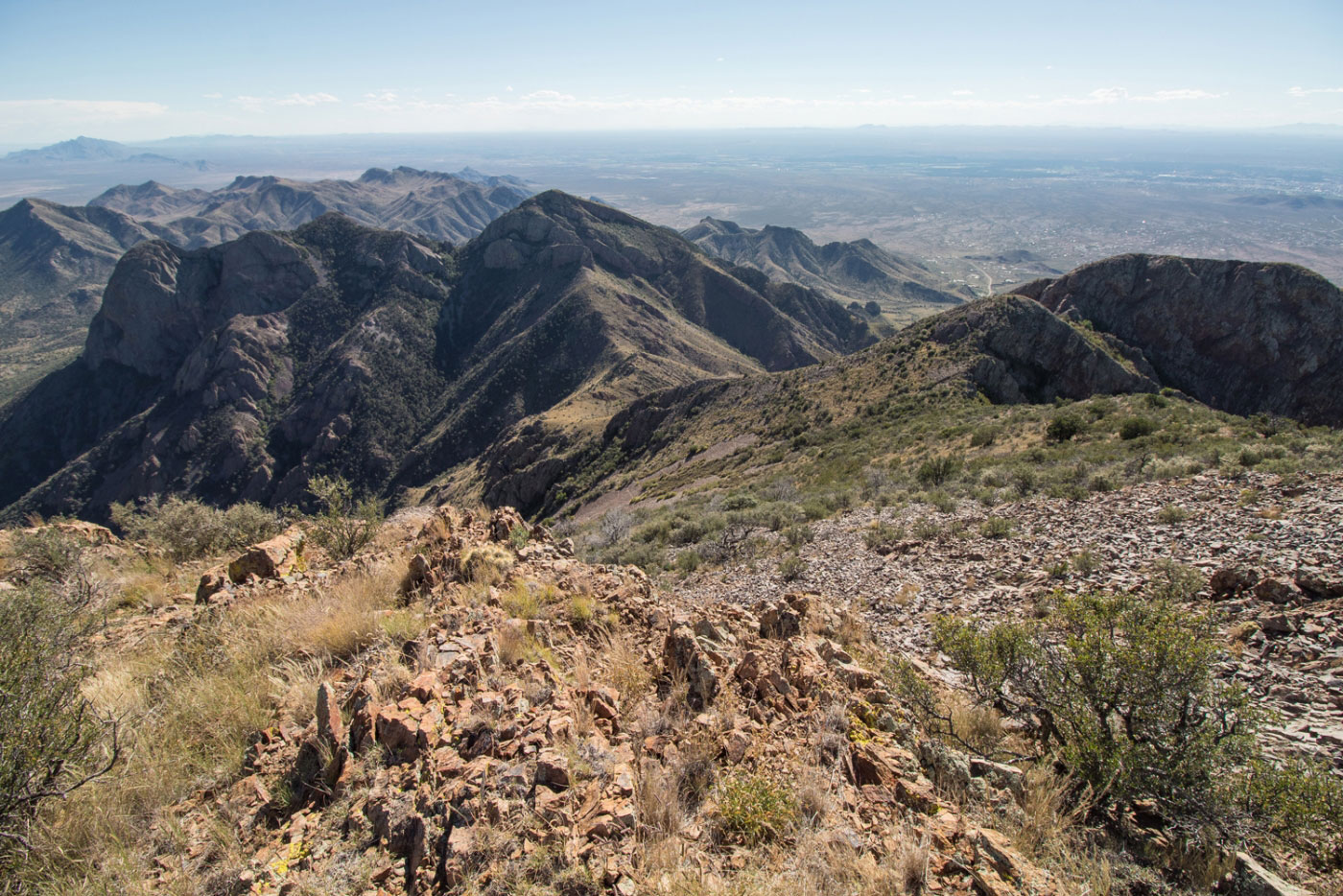
From the ridge at the top of the scree gully (the head of Bar Canyon), continue along a Class 2 ridgeline to get to the summit of Baldy Peak. You can see Organ Peak to the north, as well as the more jagged Organ Needle farther north. I was also pretty inspired to bag more of these peaks by looking south toward the southern Organ Mountains.

PEAKS ON HIKE
Elevation (ft) / Prominence (ft)
Peaks on hike
Elevation
Prominence
1
Baldy Peak
8445 ft
n/a rise

Show me some love

Please consider helping me out if you find my site useful. I'm not sponsored, so all site fees are out-of-pocket and my time preparing these trip reports is unpaid. You can also hire me as a web developer. I really appreciate it!

Thank you

Next HikePrev Hike
  • Next Hike
  • More Near Here
  • Prev Hike
photo protector Starting from the Soledad Canyon Day use Area, head up the well-traveled trail into Bar Canyon.
Starting from the Soledad Canyon Day use Area, head up the well-traveled trail into Bar Canyon.
photo protector No caption.
photo protector Ruins along the Bar Canyon Trail.
Ruins along the Bar Canyon Trail.
photo protector No caption.
photo protector Entering some narrows just before Bar Canyon Waterfall.
Entering some narrows just before Bar Canyon Waterfall.
photo protector No caption.
photo protector Waterfall. Fun Class 4 scrambling to get up via the waterfall, but apparently there is a Class 2 route to avoid the sketchy waterfall scramble.
Waterfall. Fun Class 4 scrambling to get up via the waterfall, but apparently there is a Class 2 route to avoid the sketchy waterfall scramble.
photo protector Looking down from the top of the first set of falls.
Looking down from the top of the first set of falls.
photo protector Narrow section above the first set of falls before starting the sketchiest stuff.
Narrow section above the first set of falls before starting the sketchiest stuff.
photo protector The top of the falls looking down into the narrows of Bar Canyon.
The top of the falls looking down into the narrows of Bar Canyon.
photo protector Continuing up the canyon.
Continuing up the canyon.
photo protector Bar Canyon opens up. You can see the screen field in the center (standard route, but it's dumb), and the more pleasant ridgeline on the right.
Bar Canyon opens up. You can see the screen field in the center (standard route, but it's dumb), and the more pleasant ridgeline on the right.
photo protector I opted to take the ridgeline on the way up.
I opted to take the ridgeline on the way up.
photo protector Looking back into Bar Canyon on the way up the ridgeline.
Looking back into Bar Canyon on the way up the ridgeline.
photo protector Still along the ridgeline, you can see the scree on the left.
Still along the ridgeline, you can see the scree on the left.
photo protector No caption.
photo protector At the top of the ridgeline, looking north toward Baldy Peak (white blip in the center).
At the top of the ridgeline, looking north toward Baldy Peak (white blip in the center).
photo protector Looking south toward another peak, Bar Canyon on the right.
Looking south toward another peak, Bar Canyon on the right.
photo protector Heading up the ridge to Baldy Peak.
Heading up the ridge to Baldy Peak.
photo protector On the way up to Baldy Peak looking back toward the ridgeline, Bar Canyon on the right out of frame.
On the way up to Baldy Peak looking back toward the ridgeline, Bar Canyon on the right out of frame.
photo protector Baldy peak on the right.
Baldy peak on the right.
photo protector Ridgeline I came up on on the right, southern Organ Mountains on the left.
Ridgeline I came up on on the right, southern Organ Mountains on the left.
photo protector Close-up into Bar Canyon.
Close-up into Bar Canyon.
photo protector Approaching Baldy Peak summit.
Approaching Baldy Peak summit.
photo protector No caption.
photo protector Baldy Peak summit, looking east toward Organ Peak.
Baldy Peak summit, looking east toward Organ Peak.
photo protector Baldy Peak summit looking north toward the northern organs (Organ Needle).
Baldy Peak summit looking north toward the northern organs (Organ Needle).
photo protector Baldy Peak summit looking south toward the ridgeline I came up.
Baldy Peak summit looking south toward the ridgeline I came up.

Show Me Some Love

If you find my site helpful, please help me replace my many broken cameras, fund my website fees (hosting, APIs, security), or just support my countless hours of work. I pay for all expenses myself, and all trip reports I post are unpaid and unsponsored, so any support is really appreciated!

If using PayPal, please select their option for "Sending to a friend" so they don't take out fees, thank you.

PayPalVenmoCash App

About  Contact  Love

© 2023 Stavros Basis.

DISCLAIMER: All activities you find on this site are dangerous. I am not responsible for anything you do in the outdoors. Please practice good ethics, and don't take any risks that put yourself or others in danger.


Thanks for visiting!

My site is free to use, but consider sending me a few bucks to help keep it running. Thanks in advance!

Sure!Nope.