I provide a free route map, but you can also download a hike/drive GPX to assist you and to help support my site. Before sharing my GPX tracks with others, please remember my site is a free resource and I'm charging nominal fees to offset my substantial costs.
GPX track added to your cart.
Aug 19, 2022 — This loop hits some of the most beautiful high points of the Bear River Mountains, creating a pretty fun and mostly off-trail adventure in an otherwise popular area. A few years ago I hiked Naomi Peak (which uses a well-maintained trail), but I wanted to return to include its neighbors. This was the result of a fair amount of planning to create a nice loop of Mount Magog, Naomi Peak, Bullen Hole Peak, Mount Gog, and White Pine Knob. I was also thrilled I could loop in White Pine Lake.
I started from Tony Grove Lake and headed along the Naomi Peak Trail, taking it to about 9000' at a baby pass where I headed north, leaving the trail. My first peak along the route would be Mount Magog. I ascended a mostly clear grassy slope with some light Class 2, keeping right of the rockier terrain along the crest of a spur ridge, and made my way to the peak's western ridge. Once here I headed toward the summit, where a social trail led to the right of the rocky crest before ascending some Class 2 fun to gain the summit, where I took in the lovely views of pretty much the entire route to come.
I headed along the west ridge of Mount Magog, quickly coming across a rock outcropping. Rather than drop left around it, I decided to stick to the crest (Class 2) and continued unencumbered for a while until the landscape became a bit fractured, a maze of weird landscape features. I had to drop in and out of a few gullies and avoid some rock outcrops, but somehow managed to keep the route pretty straightforward and found myself back on the Naomi Peak Trail. I followed the trail to a saddle and then took the short spur trail to reach Naomi Peak. More excellent views.
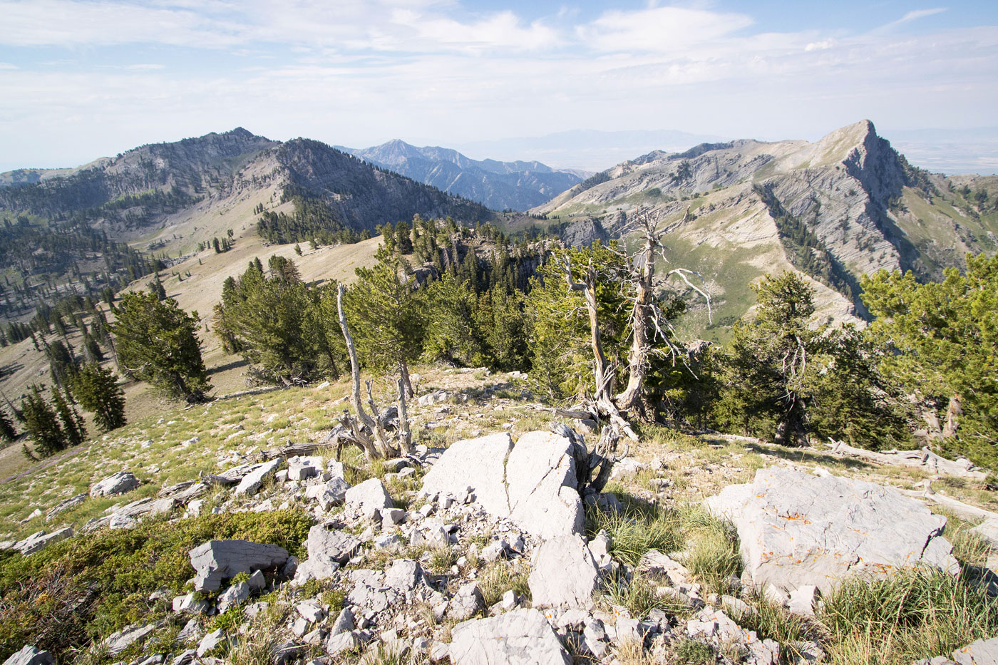
I started north along the ridgeline, where a social trail wrapped me around to the start of the ridge traverse to Bullen Peak Peak, but it faded away shortly after. I was in excellent spirits as the sweeping tundra around me was lit by morning light. Maybe I should start getting up earlier to enjoy more light like this. But like, probably not. Suddenly I came to a steep near-cliff, which surprised me since I sort of expected the ridgeline to be a no-brainer. Keeping mostly to the ridge crest, I descended loose Class 2, then side-hilled on more of the same. This section didn't last long, but it was totally out of character for the rest of the grassy traverse. After some more tundra walking, I made it to the summit of Bullen Hole Peak, which gave a really cool perspective toward Cherry Peak's sloped cliffs in the distance.
Dropping down the steep grassy east slope of Bullen Hole Peak, I noted Mount Gog ahead. It was more forested than I anticipated, but I had high hopes for it not being too annoying. Weird limestone slabs greeted me around the saddle separating the two peaks, more just cool to walk over rather than being any sort of obstacle. I started up Mount Gog, pretty much immediately locating an unexpected social trail. It took me almost the entire way to the summit, becoming more thin toward the top. A small Class 2+ cliff band served as the only real obstacle, but I'll also note that there are some large blocky features just before the summit that provide some Class 3 fun to navigate, but it can all be avoided on the right. I encountered a potential friend on the summit, but this ended up being the second time in a month an unfriendly hunter on a summit was quick to tell me how my arrival couldn't have been at a worse time. I guess, um, sorry for the inconvenience of my presence?
I backtracked from Mount Gog and was hoping to find a reasonable route down into the basin housing White Pine Lake. Almost immediately I found a social trail certainly well-beaten enough to be human-formed. Steep at times, I followed it all the way to the lake, where I picked up the White Pine Lake Trail. I was amazed at the gorgeous cliffs on the lake's west side and the towering faces of Mount Magog and Mount Gog on either side. In hindsight I wish I'd hung out a bit longer to enjoy the spot. Maybe I need to calm down a bit on these hikes... anywayyy! I took the White Pine Lake Trail as it ascended east, gaining about 500 vertical gain to reach a minor saddle above.
Just to the east was a minor summit called White Pine Knob. Despite being a bushwhack (not too bad), I felt obligated to go for this little peak since it was so close. There were actually some relatively decent views up there, but few would probably enjoy this add-on bump. I continued along the trail as it descended to Tony Grove Lake, completing the loop.
Please consider helping me out if you find my site useful. I'm not sponsored, so all site fees are out-of-pocket and my time preparing these trip reports is unpaid. You can also hire me as a web developer. I really appreciate it!


If you find my site helpful, please help me replace my many broken cameras, fund my website fees (hosting, APIs, security), or just support my countless hours of work. I pay for all expenses myself, and all trip reports I post are unpaid and unsponsored, so any support is really appreciated!
If using PayPal, please select their option for "Sending to a friend" so they don't take out fees, thank you.
My site is free to use, but consider sending me a few bucks to help keep it running. Thanks in advance!